Fruitport Charter Township, Michigan

Last updated
Fruitport Charter Township, Michigan
USA Michigan location map.svg
Red pog.svg
Fruitport Charter Township
Usa edcp location map.svg
Red pog.svg
Fruitport Charter Township
Coordinates: 43°8′52″N86°09′08″W / 43.14778°N 86.15222°W / 43.14778; -86.15222
Country United States
State Michigan
County Muskegon
Area
[1]
  Total30.4 sq mi (79 km2)
  Land30.0 sq mi (78 km2)
  Water0.4 sq mi (1 km2)
Elevation
630 ft (192 m)
Population
 (2020) [2]
  Total14,575
  Density486.3/sq mi (187.8/km2)
Time zone UTC-5 (Eastern (EST))
  Summer (DST) UTC-4 (EDT)
ZIP code
49415 (Fruitport)
49444 (Muskegon)
49456 (Spring Lake)
49448 (Nunica)
Area code 231
FIPS code 26-121-31020 [3]
GNIS feature ID1626325 [4]
Website www.fruitporttownship-mi.gov

Fruitport Charter Township is a charter township of Muskegon County in the U.S. state of Michigan. The population was 14,575 at the 2020 census. [2] The village of Fruitport is within the township.

Contents

Geography

The township is in southern Muskegon County, bordered to the south by Ottawa County. It is bordered to the west by the city of Norton Shores and partially to the north by the city of Muskegon, the county seat. The village of Fruitport is in the southern part of the township, along the county line.

Interstate 96 crosses the township, with access from Exit 4 (Airline Highway/3rd Avenue). The U.S. Route 31 freeway runs along or close to the western border of the township, with access from exits 107, 109, and 112. I-96 leads southeast 30 miles (48 km) to Grand Rapids and has its western terminus at US 31, which in turn leads north 61 miles (98 km) to Ludington and south 30 miles (48 km) to Holland.

According to the U.S. Census Bureau, the township has a total area of 30.4 square miles (79 km2), of which 30.0 square miles (78 km2) are land and 0.4 square miles (1.0 km2), or 1.29%, are water. [1] Norris Creek, a southwest-flowing tributary of Spring Lake and the Grand River, drains the southern part of the township, while Black Creek, a tributary of Mona Lake, drains the northern part.

Demographics

Historical population
CensusPop.Note
1880 880
1890 1,44664.3%
1900 927 [6] −35.9%
1910 9583.3%
1920 1,07312.0%
1930 1,45435.5%
1940 2,33060.2%
1950 4,46491.6%
1960 7,94978.1%
1970 10,21428.5%
1980 10,6464.2%
1990 11,4857.9%
2000 12,5339.1%
2010 13,5988.5%
2020 14,5757.2%
U.S. Decennial Census [7]

As of the census [3] of 2000, there were 12,533 people, 4,446 households, and 3,516 families residing in the township. The population density was 417.6 inhabitants per square mile (161.2/km2). There were 4,584 housing units at an average density of 152.7 per square mile (59.0/km2). The racial makeup of the township was 96.90% White, 0.65% African American, 0.70% Native American, 0.43% Asian, 0.45% from other races, and 0.86% from two or more races. Hispanic or Latino of any race were 1.68% of the population.

There were 4,446 households, out of which 37.9% had children under the age of 18 living with them, 67.2% were married couples living together, 8.1% had a female householder with no husband present, and 20.9% were non-families. 16.8% of all households were made up of individuals, and 7.2% had someone living alone who was 65 years of age or older. The average household size was 2.80 and the average family size was 3.15.

In the township the population was spread out, with 27.7% under the age of 18, 7.8% from 18 to 24, 29.7% from 25 to 44, 23.9% from 45 to 64, and 10.9% who were 65 years of age or older. The median age was 37 years. For every 100 females, there were 97.7 males. For every 100 females age 18 and over, there were 95.0 males.

The median income for a household in the township was $49,065, and the median income for a family was $54,634. Males had a median income of $40,165 versus $27,690 for females. The per capita income for the township was $20,582. About 5.4% of families and 6.6% of the population were below the poverty line, including 8.0% of those under age 18 and 4.8% of those age 65 or over.

Education

The township is served by the Fruitport Community Schools district. Fruitport High School, Fruitport Middle School, Shettler Elementary School, Beach Elementary School, and Edgewood Elementary School serve the township. Also located in the township is the private Calvary Christian School.

Related Research Articles

<span class="mw-page-title-main">Muskegon County, Michigan</span> County in Michigan, United States

Muskegon County is a county in the U.S. state of Michigan. As of 2020, the population was 175,824. The county seat is Muskegon.

Pennfield Charter Township is a charter township of Calhoun County in the U.S. state of Michigan. It is part of the Battle Creek, Michigan Metropolitan Statistical Area. The population was 9,001 at the 2010 census.

Colfax Township is a civil township of Mecosta County in the U.S. state of Michigan. The population was 1,962 at the 2020 census.

Green Charter Township is a charter township of Mecosta County in the U.S. state of Michigan. As of the 2020 census, the township population was 3,219. The township was organized in 1858, before Mecosta County was detached from Newaygo County.

Reynolds Township is a civil township of Montcalm County in the U.S. state of Michigan. The population was 5,431 at the 2020 census.

Egelston Township is a general law township of Muskegon County in the U.S. state of Michigan. As of the 2020 census, the township population was 11,128, up from 9,909 in 2010.

Fruitland Township is a civil township of Muskegon County in the U.S. state of Michigan. The population was 5,793 at the 2020 census.

<span class="mw-page-title-main">Fruitport, Michigan</span> Village in Michigan, United States

Fruitport is a village in Muskegon County in the U.S. state of Michigan. The population was 1,103 at the 2020 census. The community is located within Fruitport Charter Township.

Holton Township is a civil township of Muskegon County in the U.S. state of Michigan. As of the 2020 census, the township population was 2,586.

Laketon Township is a civil township of Muskegon County in the U.S. state of Michigan. The population was 7,626 at the 2020 census.

<span class="mw-page-title-main">Montague, Michigan</span> City in Michigan, United States

Montague is a city in Muskegon County in the U.S. state of Michigan. The population was 2,417 at the 2020 census. The city is politically independent from Montague Township, which borders it on three sides.

Muskegon Charter Township is a charter township of Muskegon County in the U.S. state of Michigan. The population was 17,596 at the 2020 census. The city of Muskegon borders the township to the southwest and is administratively autonomous.

<span class="mw-page-title-main">Norton Shores, Michigan</span> City in Michigan, United States

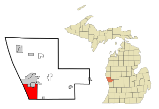
Norton Shores is a city in Muskegon County in the U.S. state of Michigan. The population was 25,030 at the 2020 census.

<span class="mw-page-title-main">Ravenna, Michigan</span> Village in Michigan, United States

Ravenna is a village in Muskegon County in the U.S. state of Michigan. The population was 1,308 at the 2020 census. The village is located in Ravenna Township.

Ravenna Township is a civil township of Muskegon County in the U.S. state of Michigan. As of the 2020 census, the population was 2,962, up from 2,905 in 2010. The village of Ravenna is located within the township.

Sullivan Township is a civil township of Muskegon County in the U.S. state of Michigan. As of the 2020 census, the township population was 2,541.

White River Township is a civil township of Muskegon County in the U.S. state of Michigan. The population was 1,383 at the 2020 census.

Whitehall Township is a civil township of Muskegon County in the U.S. state of Michigan. The population was 1,768 at the 2020 census.

<span class="mw-page-title-main">Allendale, Michigan</span> Census-designated place & unincorporated community in Michigan, United States

Allendale is a census-designated place (CDP) in Ottawa County in the U.S. state of Michigan. The population was 17,579 at the 2010 census. It is located within Allendale Charter Township, occupying approximately the northern two-thirds of the township, from the eastern boundary with the Grand River west along Pierce St., north along 75th Ave., then west along Lake Michigan Drive (M-45) to the western boundary of the township. It is a part of the Grand Rapids-Muskegon-Holland, Michigan combined statistical area, and is an exurb of Grand Rapids, due to its major commuter routes into the city.

Crockery Township is a civil township of Ottawa County in the U.S. state of Michigan. As of the 2010 census, the township population was 3,960.

References

  1. 1 2 "2023 U.S. Gazetteer Files: Michigan". United States Census Bureau. Retrieved December 12, 2023.
  2. 1 2 "P1. Race – Fruitport charter township, Michigan: 2020 DEC Redistricting Data (PL 94-171)". U.S. Census Bureau. Retrieved December 12, 2023.
  3. 1 2 "U.S. Census website". United States Census Bureau . Retrieved 2008-01-31.
  4. U.S. Geological Survey Geographic Names Information System: Fruitport Charter Township, Michigan
  5. "Twelfth Census of the United States — Minor Civil Divisions: Table 5. Populations of States and Territories by Minor Civil Divisions: 1890 and 1900—Continued" (PDF). U.S. Census Bureau. 1901. p. 211. Retrieved December 22, 2021.
  6. Sullivan Township separated prior to 1900. [5]
  7. "Decennial Census Official Publications". U.S. Census Bureau. Retrieved December 19, 2023.