Roosevelt Park, Michigan

Last updated
Roosevelt Park, Michigan
Roosevelt Park Clock.jpg
Roosevelt Park Clock
Muskegon County Michigan Incorporated and Unincorporated areas Roosevelt Park Highlighted.svg
Location in Muskegon County and the state of Michigan
Coordinates: 43°11′47″N86°16′20″W / 43.19639°N 86.27222°W / 43.19639; -86.27222
Country United States
State Michigan
County Muskegon
Area
[1]
  Total1.03 sq mi (2.66 km2)
  Land1.03 sq mi (2.66 km2)
  Water0.00 sq mi (0.00 km2)
Elevation
620 ft (189 m)
Population
 (2020) [2]
  Total4,172
  Density4,062.32/sq mi (1,567.75/km2)
Time zone UTC-5 (Eastern (EST))
  Summer (DST) UTC-4 (EDT)
ZIP code
49441 (Muskegon)
Area code 231
FIPS code 26-69520 [3]
GNIS feature ID1675441 [4]
Website rooseveltpark.org

Roosevelt Park is a city in Muskegon County in the U.S. state of Michigan. The population was 4,172 at the 2020 census, [2] up from 3,831 in 2010.

Contents

Geography

The city is in southwestern Muskegon County, bordered to the north by the city of Muskegon and to the south, east, and west by the city of Norton Shores. Downtown Muskegon is 3 miles (5 km) to the north, and Muskegon Heights is 1 mile (1.6 km) to the east.

According to the U.S. Census Bureau, the city of Roosevelt Park has a total area of 1.03 square miles (2.67 km2), all land. [1]

Demographics

Historical population
CensusPop.Note
1950 1,254
1960 2,578105.6%
1970 4,17662.0%
1980 4,015−3.9%
1990 3,885−3.2%
2000 3,8900.1%
2010 3,831−1.5%
2020 4,1728.9%
U.S. Decennial Census [5]

2010 census

As of the census [6] of 2010, there were 3,831 people, 1,731 households, and 979 families living in the city. The population density was 3,719.4 inhabitants per square mile (1,436.1/km2). There were 1,925 housing units at an average density of 1,868.9 per square mile (721.6/km2). The racial makeup of the city was 85.9% White, 8.4% African American, 0.6% Native American, 1.6% Asian, 1.1% from other races, and 2.4% from two or more races. Hispanic or Latino of any race were 3.9% of the population.

There were 1,731 households, of which 28.5% had children under the age of 18 living with them, 38.2% were married couples living together, 12.9% had a female householder with no husband present, 5.4% had a male householder with no wife present, and 43.4% were non-families. 37.5% of all households were made up of individuals, and 15.3% had someone living alone who was 65 years of age or older. The average household size was 2.19 and the average family size was 2.90.

The median age in the city was 38.3 years. 23.8% of residents were under the age of 18; 9.6% were between the ages of 18 and 24; 24.8% were from 25 to 44; 24.5% were from 45 to 64; and 17.2% were 65 years of age or older. The gender makeup of the city was 47.5% male and 52.5% female.

2000 census

As of the census [3] of 2000, there were 3,890 people, 1,773 households, and 1,056 families living in the city. The population density was 3,865.3 inhabitants per square mile (1,492.4/km2). There were 1,896 housing units at an average density of 1,884.0 per square mile (727.4/km2). The racial makeup of the city was 93.34% White, 3.14% African American, 0.46% Native American, 1.05% Asian, 0.05% Pacific Islander, 0.62% from other races, and 1.34% from two or more races. Hispanic or Latino of any race were 1.95% of the population.

There were 1,773 households, out of which 24.5% had children under the age of 18 living with them, 47.5% were married couples living together, 8.9% had a female householder with no husband present, and 40.4% were non-families. 36.6% of all households were made up of individuals, and 17.3% had someone living alone who was 65 years of age or older. The average household size was 2.16 and the average family size was 2.85.

In the city, the population was spread out, with 22.2% under the age of 18, 6.5% from 18 to 24, 26.3% from 25 to 44, 21.4% from 45 to 64, and 23.6% who were 65 years of age or older. The median age was 41 years. For every 100 females, there were 86.3 males. For every 100 females age 18 and over, there were 81.1 males.

The median income for a household in the city was $37,035, and the median income for a family was $47,043. Males had a median income of $36,917 versus $30,118 for females. The per capita income for the city was $19,825. About 2.6% of families and 4.8% of the population were below the poverty line, including 6.1% of those under age 18 and 3.5% of those age 65 or over.

Images

Related Research Articles

<span class="mw-page-title-main">Muskegon County, Michigan</span> County in Michigan, United States

Muskegon County is a county in the U.S. state of Michigan. As of 2020, the population was 175,824. The county seat is Muskegon.

<span class="mw-page-title-main">Decatur, Arkansas</span> City in Arkansas, United States

Decatur is a city, in Benton County, Arkansas, United States. The population was 1,773 at the 2020 census. It is part of the Northwest Arkansas region. This town is named after Commodore Stephen Decatur, Jr.

<span class="mw-page-title-main">Lake City, Iowa</span> City in Iowa, United States

Lake City is a city in Calhoun County, Iowa, United States, founded in 1856. The population was 1,731 at the time of the 2020 census. The sign coming into town proudly proclaims that Lake City has "Everything but a Lake."

<span class="mw-page-title-main">Winterfield Township, Michigan</span> Civil township in Michigan, United States

Winterfield Township is a civil township of Clare County in the U.S. state of Michigan. The population was 460 at the 2020 census.
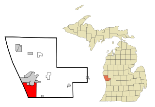
<span class="mw-page-title-main">Mecosta, Michigan</span> Village in Michigan, United States

Mecosta is a village in Mecosta County in the U.S. state of Michigan. The population was 386 at the 2020 census, down from 457 in 2010. The village is within Morton Township. Mecosta Township, which is also in Mecosta County, is located several miles to the west.

<span class="mw-page-title-main">Forest Township, Missaukee County, Michigan</span> Civil township in Michigan, United States

Forest Township is a civil township of Missaukee County in the U.S. state of Michigan. The population was 1,184 at the 2020 census.

<span class="mw-page-title-main">Lakewood Club, Michigan</span> Village in Michigan, United States

Lakewood Club is a village in Dalton Township of Muskegon County in the U.S. state of Michigan. The population was 1,291 at the 2010 census.

Muskegon Charter Township is a charter township of Muskegon County in the U.S. state of Michigan. The population was 17,737 at the 2000 census. The City of Muskegon is at the southwest corner of the township and is administratively autonomous. The township shares all five of the city's zip codes.

<span class="mw-page-title-main">Muskegon Heights, Michigan</span> City in Michigan, United States

Muskegon Heights is a city in Muskegon County in the U.S. state of Michigan. The population was 9,985 at the 2020 census.

<span class="mw-page-title-main">North Muskegon, Michigan</span> City in Michigan, United States

North Muskegon is a city in Muskegon County in the U.S. state of Michigan. The population was 4,093 at the 2020 census, up from 3,786 in 2010.

<span class="mw-page-title-main">Norton Shores, Michigan</span> City in Michigan, United States

Norton Shores is a city in Muskegon County in the U.S. state of Michigan. The population was 25,030 at the 2020 census.

<span class="mw-page-title-main">Wolf Lake, Michigan</span> Census-designated place & unincorporated community in Michigan, United States

Wolf Lake is an unincorporated community and census-designated place (CDP) in Muskegon County in the U.S. state of Michigan. At the 2020 census, the population of Wolf Lake was 5,034. As an unincorporated community, Wolf Lake is governed by Egelston Township. The community lies 4 miles (6.4 km) east of the city of Muskegon.

<span class="mw-page-title-main">Newaygo, Michigan</span> City in Michigan, United States

Newaygo is a rural city in Newaygo County in the U.S. state of Michigan. The population was 2,471 at the 2020 census.

<span class="mw-page-title-main">Leonard, Minnesota</span> City in Minnesota, United States

Leonard is a city in Clearwater County, Minnesota, United States. The population was 41 at the 2020 census.

<span class="mw-page-title-main">Woodson Terrace, Missouri</span> City in Missouri, United States

Woodson Terrace is a city in St. Louis County, Missouri, United States. The population was 4,063 at the 2010 census.

<span class="mw-page-title-main">Polkville, Mississippi</span> Town in Mississippi, United States

Polkville is a town in Smith County, Mississippi. The population is at 833 as of the 2010 census.

<span class="mw-page-title-main">Mayfield Heights, Ohio</span> City in Ohio, United States

Mayfield Heights is a city in Cuyahoga County, Ohio, United States. The population was 20,351 at the 2020 census. An eastern suburb of Cleveland, it is part of the Cleveland metropolitan area.

<span class="mw-page-title-main">Eleanor, West Virginia</span> Town in West Virginia, United States

Eleanor is a town in Putnam County, West Virginia, United States, along the Kanawha River. Its population was 1,548 at the 2020 census. It is part of the Huntington–Ashland metropolitan area. The town, named for Eleanor Roosevelt, was established as a New Deal project in the 1930s like other Franklin D. Roosevelt towns around the nation.

<span class="mw-page-title-main">Fair Oaks Ranch, Texas</span> City in Texas, United States

Fair Oaks Ranch is a city in Bexar, Comal, and Kendall counties in the U.S. state of Texas. The population was 5,986 at the 2010 census and an estimated 9,700 in 2018. It is part of the San Antonio-New Braunfels Metropolitan Statistical Area. The city was named after Ralph Fair Sr, an oilman who had a large cattle ranch on the now residential town. The Fair family decided to sell a portion of the ranch to build what is now Fair Oaks Ranch in 1975.

Newport is a census-designated place (CDP) consisting of the main area of settlement within the town of Newport in Penobscot County, Maine, United States. The population of the CDP was 1,776 at the 2010 census.

References

  1. 1 2 "2023 U.S. Gazetteer Files: Michigan". United States Census Bureau. Retrieved December 14, 2023.
  2. 1 2 "P1. Race – Roosevelt Park city, Michigan: 2020 DEC Redistricting Data (PL 94-171)". U.S. Census Bureau. Retrieved December 14, 2023.
  3. 1 2 "U.S. Census website". United States Census Bureau . Retrieved 2008-01-31.
  4. U.S. Geological Survey Geographic Names Information System: Roosevelt Park, Michigan
  5. "Census of Population and Housing". Census.gov. Retrieved June 4, 2016.
  6. "U.S. Census website". United States Census Bureau . Retrieved 2012-11-25.

43°11′47″N86°16′20″W / 43.19639°N 86.27222°W / 43.19639; -86.27222