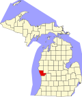
Wolf Lake, Michigan

Last updated

Wolf Lake, Michigan
Muskegon County Michigan Incorporated and Unincorporated areas Wolf Lake Highlighted.svg
Location in Muskegon County and the state of Michigan
Coordinates: 43°15′17″N86°6′35″W / 43.25472°N 86.10972°W / 43.25472; -86.10972
Country Flag of the United States.svg United States
State Flag of Michigan.svg  Michigan
County Muskegon
Township Egelston
Area
[1]
  Total3.92 sq mi (10.16 km2)
  Land3.54 sq mi (9.18 km2)
  Water0.38 sq mi (0.98 km2)
Elevation
673 ft (205 m)
Population
 (2020) [2]
  Total5,034
  Density1,420.43/sq mi (548.51/km2)
Time zone UTC-5 (Eastern (EST))
  Summer (DST) UTC-4 (EDT)
ZIP code
49442 (Muskegon)
FIPS code 26-88220 [3]
GNIS feature ID1622197 [4]

Wolf Lake is an unincorporated community and census-designated place (CDP) in Muskegon County in the U.S. state of Michigan. At the 2020 census, the population of Wolf Lake was 5,034, [2] up from 4,104 in 2010. [5] As an unincorporated community, Wolf Lake is governed by Egelston Township.

Contents

Geography

Wolf Lake is in central Muskegon County, in the western part of Egelston Township. It is 8 miles (13 km) east of downtown Muskegon. According to the U.S. Census Bureau, the community has a total area of 3.92 square miles (10.2 km2), of which 3.54 square miles (9.2 km2) are land and 0.38 square miles (0.98 km2), or 9.66%, are water. [1] Wolf Lake, the community's namesake, is a natural lake in the northern part of the CDP.

Major highways

Demographics

Historical population
CensusPop.Note
1950 1,591
1960 2,52558.7%
1970 2,258−10.6%
1980 3,87671.7%
1990 4,1106.0%
2000 4,4558.4%
2010 4,104−7.9%
2020 5,03422.7%
U.S. Decennial Census [7]

As of the census [3] of 2000, there were 4,455 people, 1,670 households, and 1,202 families residing in the community. The population density was 1,279.0 inhabitants per square mile (493.8/km2). There were 1,761 housing units at an average density of 505.6 per square mile (195.2/km2). The racial makeup of the community was 94.30% White, 1.03% African American, 1.23% Native American, 0.09% Asian, 1.41% from other races, and 1.93% from two or more races. Hispanic or Latino of any race were 4.22% of the population.

There were 1,670 households, out of which 36.3% had children under the age of 18 living with them, 53.9% were married couples living together, 12.8% had a female householder with no husband present, and 28.0% were non-families. 22.5% of all households were made up of individuals, and 10.1% had someone living alone who was 65 years of age or older. The average household size was 2.66 and the average family size was 3.10.

In the community, the population was spread out, with 27.9% under the age of 18, 9.5% from 18 to 24, 29.0% from 25 to 44, 22.3% from 45 to 64, and 11.2% who were 65 years of age or older. The median age was 34 years. For every 100 females, there were 96.6 males. For every 100 females age 18 and over, there were 94.0 males.

The median income for a household in the community was $34,799, and the median income for a family was $37,847. Males had a median income of $32,197 versus $25,272 for females. The per capita income for the community was $16,214. About 6.1% of families and 8.1% of the population were below the poverty line, including 12.5% of those under age 18 and 7.8% of those age 65 or over.

Related Research Articles

<span class="mw-page-title-main">Muskegon County, Michigan</span> County in Michigan, United States

Muskegon County is a county in the U.S. state of Michigan. As of 2020, the population was 175,824. The county seat is Muskegon.

<span class="mw-page-title-main">Tucson Estates, Arizona</span> CDP in Arizona, United States

Tucson Estates is a census-designated place (CDP) in Pima County, Arizona, United States. The population was 9,755 at the 2000 census.

Fox Lake Hills is an unincorporated community and census-designated place (CDP) in Lake Villa Township, Lake County, Illinois, United States. Per the 2020 census, the population was 2,684.

<span class="mw-page-title-main">Lake Michigan Beach, Michigan</span> Census-designated place & unincorporated community in Michigan, United States

Lake Michigan Beach is an unincorporated community in Berrien County in the U.S. state of Michigan. It is a census-designated place (CDP) for statistical purposes, without any legal status as a municipality. The population was 1,216 at the 2010 census.

<span class="mw-page-title-main">Michigan Center, Michigan</span> Census-designated place & unincorporated community in Michigan, United States

Michigan Center is an unincorporated community and census-designated place (CDP) in Jackson County in the U.S. state of Michigan. The population was 4,672 at the 2010 census. The CDP is located within Leoni Township on the eastern border of the city of Jackson.

<span class="mw-page-title-main">South Gull Lake, Michigan</span> Census-designated place & unincorporated community in Michigan, United States

South Gull Lake is a census-designated place (CDP) in Ross Township, Kalamazoo County, in the U.S. state of Michigan. It includes the unincorporated communities of Yorkville, Gull Lake, and Midland Park and does not have any legal status as an incorporated municipality. The population of the CDP was 1,182 at the 2010 census, down from 1,526 at the 2000 census.

<span class="mw-page-title-main">Harvey, Michigan</span> Census-designated place & unincorporated community in Michigan, United States

Harvey is a census-designated place (CDP) in Marquette County in the U.S. state of Michigan. The population was 3,244 as of the 2020 census, up from 1,393 in 2010, before the CDP was enlarged by the Census Bureau. The CDP is located within Chocolay and Sands townships.

<span class="mw-page-title-main">Trowbridge Park, Michigan</span> Census-designated place & unincorporated community in Michigan, United States

Trowbridge Park is an unincorporated community in Marquette Township, Marquette County, in the U.S. state of Michigan. It is also a census-designated place (CDP) for statistical purposes and has no legal status as an incorporated municipality. The CDP had a population of 2,287 at the 2020 census. The community is located within Marquette Township and borders the city of Marquette on the east and north.

<span class="mw-page-title-main">Canadian Lakes, Michigan</span> Census-designated place in Michigan, United States

Canadian Lakes is an unincorporated community and census-designated place (CDP) in Mecosta County in the U.S. state of Michigan. The area is mostly within the southwest portion of Morton Township, southwest of Mecosta and east of Stanwood. As of the 2020 census, the CDP population was 3,202, up from 2,756 in 2010. The area defined by the CDP includes small portions in eastern Austin Township.

Chippewa Township is a civil township of Mecosta County in the U.S. state of Michigan. As of the 2020 census, the township population was 1,227.

<span class="mw-page-title-main">Canada Creek Ranch, Michigan</span> Census-designated place in Michigan, United States

Canada Creek Ranch is an unincorporated community in Montmorency Township, Montmorency County, in the U.S. state of Michigan. It is a census-designated place (CDP) used for statistical purposes. The population was 258 at the 2020 census, down from 304 in 2010.

<span class="mw-page-title-main">Lewiston, Michigan</span> Census-designated place in Michigan, United States

Lewiston is an unincorporated community in Montmorency County, Michigan, United States. It is a census-designated place (CDP) for statistical purposes. The population was 996 at the 2020 census.

Egelston Township is a general law township of Muskegon County in the U.S. state of Michigan. As of the 2010 census, the township population was 9,909.

<span class="mw-page-title-main">Fruitport, Michigan</span> Village in Michigan, United States

Fruitport is a village in Muskegon County in the U.S. state of Michigan. The population was 1,103 at the 2020 census. The community is located within Fruitport Charter Township.

<span class="mw-page-title-main">North Muskegon, Michigan</span> City in Michigan, United States

North Muskegon is a city in Muskegon County in the U.S. state of Michigan. The population was 4,093 at the 2020 census, up from 3,786 in 2010.

<span class="mw-page-title-main">Twin Lake, Michigan</span> Census-designated place in Michigan, United States

Twin Lake is an unincorporated community in Muskegon County of the U.S. state of Michigan. It is a census-designated place (CDP) for statistical purposes. Local government services are provided by Dalton Township. As of the 2020 census, the population of the CDP was 2,056. The surrounding area is the home of Blue Lake Fine Arts Camp, the YMCA's Camp Pinewood, and the Boy Scouts' Gerber Scout Reservation and Owasippe Scout Reservation.

<span class="mw-page-title-main">Croton Township, Michigan</span> Civil township in Michigan, United States

Croton Township is a civil township of Newaygo County in the U.S. state of Michigan. The population was 3,368 at the 2020 census.

<span class="mw-page-title-main">Prudenville, Michigan</span> Census-designated place & unincorporated community in Michigan, United States

Prudenville is an unincorporated community and census-designated place (CDP) in Roscommon County in the U.S. state of Michigan. The population was 1,643 at the 2020 census. Prudenville is located within Denton Township.

<span class="mw-page-title-main">Legend Lake, Wisconsin</span> CDP in Wisconsin, United States

Legend Lake is a census-designated place (CDP) in Menominee County, Wisconsin, Wisconsin, United States, on the Menominee Indian Reservation. The population was 1,670 at the 2020 census.

Austin Township is a civil township of Mecosta County in the U.S. state of Michigan. As of the 2020 census, the township population was 1,715.

References

  1. 1 2 "2023 U.S. Gazetteer Files: Michigan". United States Census Bureau. Retrieved December 18, 2023.
  2. 1 2 "P1. Race – Wolf Lake CDP, Michigan: 2020 DEC Redistricting Data (PL 94-171)". U.S. Census Bureau. Retrieved December 18, 2023.
  3. 1 2 "U.S. Census website". United States Census Bureau . Retrieved January 31, 2008.
  4. U.S. Geological Survey Geographic Names Information System: Wolf Lake, Michigan
  5. "P1. Race – Wolf Lake CDP, Michigan: 2020 DEC Redistricting Data (PL 94-171)". U.S. Census Bureau. Retrieved December 18, 2023.
  6. Wolf Lake CDP, Michigan - Reference Map - American FactFinder Archived 2020-02-10 at archive.today , U.S Census Bureau, 2000 census
  7. "Decennial Census Official Publications". Census.gov. Retrieved December 18, 2023.

43°15′17″N86°06′35″W / 43.25472°N 86.10972°W / 43.25472; -86.10972