Montague Township, Michigan

Last updated

Montague Township, Michigan
USA Michigan location map.svg
Red pog.svg
Montague Township
Usa edcp location map.svg
Red pog.svg
Montague Township
Coordinates: 43°26′10″N86°21′03″W / 43.43611°N 86.35083°W / 43.43611; -86.35083
Country United States
State Michigan
County Muskegon
Area
[1]
  Total20.0 sq mi (52 km2)
  Land19.1 sq mi (49 km2)
  Water0.9 sq mi (2 km2)
Elevation
679 ft (310 m)
Population
 (2020) [2]
  Total1,555
  Density81.3/sq mi (31.4/km2)
Time zone UTC-5 (EST)
  Summer (DST) UTC-4 (EDT)
ZIP code
49437 (Montague)
Area code 231
FIPS code 26-121-55120 [3]
GNIS feature ID1626758 [4]
Website www.montaguetownship.com

Montague Township is a civil township of Muskegon County in the U.S. state of Michigan. The population was 1,555 at the 2020 census. [2] It is adjacent to the city of Montague.

Contents

Geography

The township is in northwestern Muskegon County, bordered to the north by Oceana County. The city of Montague borders the southwest portion of the township, and a portion of the city of Whitehall borders the township to the south, across the White River. U.S. Route 31, a four-lane freeway, crosses the township, leading south to Muskegon, the county seat, and north to the Ludington area.

According to the U.S. Census Bureau, Montague Township has a total area of 20.0 square miles (52 km2), of which 19.1 square miles (49 km2) are land and 0.9 square miles (2.3 km2), or 4.49%, are water. [1] Most of the township drains south toward the White River and White Lake, an arm of Lake Michigan, while the northern part is drained by Flower Creek, which flows west directly to Lake Michigan.

Clear Springs Nature Preserve is located in the township. [5]

Demographics

Historical population
CensusPop.Note
1880 1,950
1890 1,9670.9%
1900 1,384−29.6%
1910 1,315−5.0%
1920 1,160−11.8%
1930 1,1610.1%
1940 392 [7] −66.2%
1950 57446.4%
1960 89956.6%
1970 1,14727.6%
1980 1,35918.5%
1990 1,4295.2%
2000 1,63714.6%
2010 1,600−2.3%
2020 1,555−2.8%
U.S. Decennial Census [8]

As of the census [3] of 2000, there were 1,637 people, 601 households, and 456 families residing in the township. The population density was 86.6 inhabitants per square mile (33.4/km2). There were 651 housing units at an average density of 34.4 per square mile (13.3/km2). The racial makeup of the township was 95.97% White, 1.41% African American, 1.22% Native American, 0.18% Asian, 0.61% from other races, and 0.61% from two or more races. Hispanic or Latino of any race were 2.02% of the population.

There were 601 households, out of which 34.3% had children under the age of 18 living with them, 63.7% were married couples living together, 8.5% had a female householder with no husband present, and 24.1% were non-families. 19.0% of all households were made up of individuals, and 9.0% had someone living alone who was 65 years of age or older. The average household size was 2.67 and the average family size was 3.05.

In the township the population was spread out, with 25.7% under the age of 18, 9.1% from 18 to 24, 27.6% from 25 to 44, 25.6% from 45 to 64, and 12.0% who were 65 years of age or older. The median age was 37 years. For every 100 females, there were 102.9 males. For every 100 females age 18 and over, there were 100.2 males.

The median income for a household in the township was $41,534, and the median income for a family was $46,471. Males had a median income of $35,650 versus $23,958 for females. The per capita income for the township was $17,695. About 4.1% of families and 7.1% of the population were below the poverty line, including 7.6% of those under age 18 and 2.7% of those age 65 or over.

Notable people

President Abraham Lincoln's first cousin, Hannah Lincoln Sammis, is buried in the township. [9]

Related Research Articles

<span class="mw-page-title-main">Muskegon County, Michigan</span> County in Michigan, United States

Muskegon County is a county in the U.S. state of Michigan. As of 2020, the population was 175,824. The county seat is Muskegon.

<span class="mw-page-title-main">Forest Township, Missaukee County, Michigan</span> Civil township in Michigan, United States

Forest Township is a civil township of Missaukee County in the U.S. state of Michigan. The population was 1,184 at the 2020 census.

<span class="mw-page-title-main">Lake Township, Missaukee County, Michigan</span> Civil township in Michigan, United States

Lake Township is a civil township of Missaukee County in the U.S. state of Michigan. The population was 2,827 at the 2020 census, which makes it the county's most-populated municipality.

Reynolds Township is a civil township of Montcalm County in the U.S. state of Michigan. The population was 5,431 at the 2020 census.

Dalton Township is a civil township of Muskegon County in the U.S. state of Michigan. As of the 2020 census, the township population was 9,427.

Egelston Township is a general law township of Muskegon County in the U.S. state of Michigan. As of the 2020 census, the township population was 11,128, up from 9,909 in 2010.

Fruitland Township is a civil township of Muskegon County in the U.S. state of Michigan. The population was 5,793 at the 2020 census.

Fruitport Charter Township is a charter township of Muskegon County in the U.S. state of Michigan. The population was 14,575 at the 2020 census. The village of Fruitport is within the township.

Laketon Township is a civil township of Muskegon County in the U.S. state of Michigan. The population was 7,626 at the 2020 census.

<span class="mw-page-title-main">Montague, Michigan</span> City in Michigan, United States

Montague is a city in Muskegon County in the U.S. state of Michigan. The population was 2,417 at the 2020 census. The city is politically independent from Montague Township, which borders it on three sides.

Moorland Township is a civil township of Muskegon County in the U.S. state of Michigan. The population was 1,627 at the 2020 census.

Muskegon Charter Township is a charter township of Muskegon County in the U.S. state of Michigan. The population was 17,596 at the 2020 census. The city of Muskegon borders the township to the southwest and is administratively autonomous.

<span class="mw-page-title-main">North Muskegon, Michigan</span> City in Michigan, United States

North Muskegon is a city in Muskegon County in the U.S. state of Michigan. The population was 4,093 at the 2020 census, up from 3,786 in 2010.

<span class="mw-page-title-main">Norton Shores, Michigan</span> City in Michigan, United States

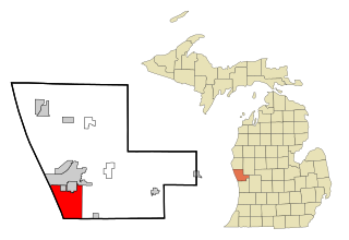
Norton Shores is a city in Muskegon County in the U.S. state of Michigan. The population was 25,030 at the 2020 census.

<span class="mw-page-title-main">Twin Lake, Michigan</span> Census-designated place in Michigan, United States

Twin Lake is an unincorporated community in Muskegon County of the U.S. state of Michigan. It is a census-designated place (CDP) for statistical purposes. Local government services are provided by Dalton Township. As of the 2020 census, the population of the CDP was 2,056. The surrounding area is the home of Blue Lake Fine Arts Camp, the YMCA's Camp Pinewood, and the Boy Scouts' Gerber Scout Reservation and Owasippe Scout Reservation.

<span class="mw-page-title-main">Whitehall, Michigan</span> City in Michigan, United States

Whitehall is a city in Muskegon County in the U.S. state of Michigan. The population was 2,909 at the 2020 census. The city is located to the west of Whitehall Township. Montague is its neighbor.

<span class="mw-page-title-main">Wolf Lake, Michigan</span> Census-designated place in Michigan, United States

Wolf Lake is an unincorporated community and census-designated place (CDP) in Muskegon County in the U.S. state of Michigan. At the 2020 census, the population of Wolf Lake was 5,034, up from 4,104 in 2010. As an unincorporated community, Wolf Lake is governed by Egelston Township.

Austin Township is a civil township of Mecosta County in the U.S. state of Michigan. As of the 2020 census, the township population was 1,715.

Blue Lake Township is a civil township of Muskegon County in the U.S. state of Michigan. As of the 2020 census, the township population was 2,416. One of the largest landowners in the township is the Pathway to Adventure Council of the Boy Scouts of America, which owns Owasippe Scout Reservation. The township is also home to the Blue Lake Fine Arts Camp.

Cedar Creek Township is a civil township of Muskegon County in the U.S. state of Michigan. The population was 3,192 at the 2020 census.

References

  1. 1 2 "2023 U.S. Gazetteer Files: Michigan". United States Census Bureau. Retrieved December 21, 2023.
  2. 1 2 "P1. Race – Montague township, Michigan: 2020 DEC Redistricting Data (PL 94-171)". U.S. Census Bureau. Retrieved December 21, 2023.
  3. 1 2 "U.S. Census website". United States Census Bureau . Retrieved January 31, 2008.
  4. U.S. Geological Survey Geographic Names Information System: Montague Township, Michigan
  5. "Clear Springs Nature Preserve". www.visitmuskegon.org. March 11, 2022. Archived from the original on March 12, 2023. Retrieved March 12, 2023.
  6. "A Brief History of Montague". City of Montague. Retrieved December 21, 2021.
  7. Montague village separated from the township and was incorporated as a city in 1935. [6]
  8. "Decennial Census Official Publications". U.S. Census Bureau. Retrieved December 21, 2023.
  9. "Montague - Facts and Figures". mylocalgov.com. Archived from the original on September 27, 2007.