Ravenna, Michigan

Last updated

Ravenna, Michigan
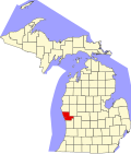
Muskegon County Michigan Incorporated and Unincorporated areas Ravenna Highlighted.svg
Location in Muskegon County and the state of Michigan
Coordinates: 43°11′22″N85°56′13″W / 43.18944°N 85.93694°W / 43.18944; -85.93694
Country United States
State Michigan
County Muskegon
Township Ravenna
Area
[1]
  Total1.19 sq mi (3.09 km2)
  Land1.19 sq mi (3.08 km2)
  Water0.00 sq mi (0.00 km2)
Elevation
673 ft (205 m)
Population
 (2020) [2]
  Total1,308
  Density1,098.24/sq mi (424.07/km2)
Time zone UTC-5 (Eastern (EST))
  Summer (DST) UTC-4 (EDT)
ZIP code
49451
Area code 231
FIPS code 26-67280 [3]
GNIS feature ID1618856 [4]
Website www.ravennami.com

Ravenna is a village in Muskegon County in the U.S. state of Michigan. The population was 1,308 at the 2020 census. [2] The village is located in Ravenna Township.

Contents

Geography

Ravenna in southeastern Muskegon County, in the northeast part of Ravenna Township. It is 17 miles (27 km) east of Muskegon, the county seat, 9 miles (14 km) north of Coopersville, and 23 miles (37 km) northwest of Grand Rapids.

According to the U.S. Census Bureau, Ravenna has a total area of 1.19 square miles (3.08 km2), all of it recorded as land. [1] Crockery Creek passes through the east side of the village, flowing southwest to join the Grand River east of Grand Haven.

Education

Public elementary and secondary education is provided by the Ravenna Public Schools. It is a small rural district with Beechnau Elementary School for students in preschool through grade four, Ravenna Middle School for grades five through eight, and Ravenna High School for grades nine through twelve. Beechnau is located in the village along with the school district offices, while both the middle and high schools are located on a campus just north of the village limits that includes a football stadium, track, athletic fields, and the district bus garage. Ravenna is also the district of record for the North East Education Center, which is located in Muskegon and serves emotionally impaired students from most of the schools in Muskegon County. The schools offer many extracurricular activities both in sports and academics. [5] Ravenna also has one private elementary school, Divine Providence Academy, which has a campus at St. Catherine parish. The school is part of the Roman Catholic Diocese of Grand Rapids and has students from preschool through eighth grade. [6]

Demographics

Historical population
CensusPop.Note
1930 343
1940 45131.5%
1950 55122.2%
1960 80145.4%
1970 1,04830.8%
1980 951−9.3%
1990 919−3.4%
2000 1,20631.2%
2010 1,2191.1%
2020 1,3087.3%
U.S. Decennial Census [7]

2010 census

As of the census [8] of 2010, there were 1,219 people, 454 households, and 325 families living in the village. The population density was 1,007.4 inhabitants per square mile (389.0/km2). There were 476 housing units at an average density of 393.4 per square mile (151.9/km2). The racial makeup of the village was 94.0% White, 0.2% African American, 0.7% Native American, 3.4% from other races, and 1.7% from two or more races. Hispanic or Latino of any race were 6.4% of the population.

There were 454 households, of which 40.7% had children under the age of 18 living with them, 55.7% were married couples living together, 11.5% had a female householder with no husband present, 4.4% had a male householder with no wife present, and 28.4% were non-families. 24.7% of all households were made up of individuals, and 12.1% had someone living alone who was 65 years of age or older. The average household size was 2.67 and the average family size was 3.18.

The median age in the village was 35.2 years. 29% of residents were under the age of 18; 7.7% were between the ages of 18 and 24; 27.2% were from 25 to 44; 22.5% were from 45 to 64; and 13.5% were 65 years of age or older. The gender makeup of the village was 49.0% male and 51.0% female.

2000 census

As of the census [3] of 2000, there were 1,206 people, 437 households, and 340 families living in the village. The population density was 958.1 inhabitants per square mile (369.9/km2). There were 455 housing units at an average density of 361.5 per square mile (139.6/km2). The racial makeup of the village was 97.26% White, 0.41% Native American, 0.08% Asian, 1.24% from other races, and 1.00% from two or more races. Hispanic or Latino of any race were 1.74% of the population.

There were 437 households, out of which 40.3% had children under the age of 18 living with them, 65.2% were married couples living together, 8.7% had a female householder with no husband present, and 22.0% were non-families. 19.0% of all households were made up of individuals, and 10.1% had someone living alone who was 65 years of age or older. The average household size was 2.76 and the average family size was 3.16.

In the village, the population was spread out, with 30.1% under the age of 18, 7.4% from 18 to 24, 32.0% from 25 to 44, 18.7% from 45 to 64, and 11.9% who were 65 years of age or older. The median age was 33 years. For every 100 females, there were 90.8 males. For every 100 females age 18 and over, there were 89.9 males.

The median income for a household in the village was $47,167, and the median income for a family was $51,458. Males had a median income of $40,426 versus $28,646 for females. The per capita income for the village was $19,197. About 1.7% of families and 3.7% of the population were below the poverty line, including 3.4% of those under age 18 and 2.2% of those age 65 or over.

Notable people

Related Research Articles

<span class="mw-page-title-main">Muskegon County, Michigan</span> County in Michigan, United States

Muskegon County is a county in the U.S. state of Michigan. As of 2020, the population was 175,824. The county seat is Muskegon.

<span class="mw-page-title-main">Homedale, Idaho</span> City in Idaho, United States

Homedale is a city in Owyhee County Idaho. The population was 2,633 at the time of the 2010 census. The town name was chosen by drawing names from a hat during a community picnic. Homedale is part of the Boise metropolitan area. It was, at one time, the terminus of a branch of the Oregon Short Line Railroad.

<span class="mw-page-title-main">Cantrall, Illinois</span> Village in Illinois, United States

Cantrall is a village in Sangamon County, Illinois, United States. The population was 144 at the 2020 census, up from 139 in 2010. It is part of the Springfield, Illinois Metropolitan Statistical Area.

<span class="mw-page-title-main">Morley, Michigan</span> Village in Michigan, United States

Morley is a village in Mecosta County in the U.S. state of Michigan. The population was 517 at the 2020 census.

<span class="mw-page-title-main">Lakeview, Michigan</span> Village in Michigan, United States

Lakeview is a village in Cato Township in Montcalm County of the U.S. state of Michigan. The population was 1,024 at the 2020 census.

Reynolds Township is a civil township of Montcalm County in the U.S. state of Michigan. The population was 5,431 at the 2020 census.

<span class="mw-page-title-main">Fruitport, Michigan</span> Village in Michigan, United States

Fruitport is a village in Muskegon County in the U.S. state of Michigan. The population was 1,103 at the 2020 census. The community is located within Fruitport Charter Township.

Fruitport Charter Township is a charter township of Muskegon County in the U.S. state of Michigan. The population was 14,575 at the 2020 census. The village of Fruitport is within the township.

Laketon Township is a civil township of Muskegon County in the U.S. state of Michigan. The population was 7,626 at the 2020 census.

<span class="mw-page-title-main">Lakewood Club, Michigan</span> Village in Michigan, United States

Lakewood Club is a village in Dalton Township of Muskegon County in the U.S. state of Michigan. The population was 1,340 at the 2020 census.

<span class="mw-page-title-main">Montague, Michigan</span> City in Michigan, United States

Montague is a city in Muskegon County, Michigan, United States. The population was 2,417 at the 2020 census. The city is politically independent from Montague Township, which borders it on three sides.

Montague Township is a civil township of Muskegon County in the U.S. state of Michigan. The population was 1,555 at the 2020 census. It is adjacent to the city of Montague.

<span class="mw-page-title-main">Muskegon Heights, Michigan</span> City in Michigan, United States

Muskegon Heights is a city in Muskegon County in the U.S. state of Michigan. The population was 9,985 at the 2020 census.

<span class="mw-page-title-main">North Muskegon, Michigan</span> City in Michigan, United States

North Muskegon is a city in Muskegon County in the U.S. state of Michigan. The population was 4,093 at the 2020 census, up from 3,786 in 2010.

<span class="mw-page-title-main">Norton Shores, Michigan</span> City in Michigan, United States

Norton Shores is a city in Muskegon County in the U.S. state of Michigan. The population was 25,030 at the 2020 census.

Ravenna Township is a civil township of Muskegon County in the U.S. state of Michigan. As of the 2020 census, the population was 2,962, up from 2,905 in 2010. The village of Ravenna is located within the township.

Sullivan Township is a civil township of Muskegon County in the U.S. state of Michigan. As of the 2020 census, the township population was 2,541.

<span class="mw-page-title-main">Hersey, Michigan</span> Village in Michigan, United States

Hersey is a village in Osceola County in the U.S. state of Michigan. The population was 350 at the 2010 census. The village is located within Hersey Township.

Chester Township is a civil township of Ottawa County in the U.S. state of Michigan. As of the 2020 United States Census, the township population was 2,096.

<span class="mw-page-title-main">Casnovia, Michigan</span> Village in Michigan, United States

Casnovia is a village in the U.S. state of Michigan. It is situated on the boundary between Muskegon and Kent counties and lies partially within each. The population was 316 at the 2020 census.

References

  1. 1 2 "2023 U.S. Gazetteer Files: Michigan". United States Census Bureau. Retrieved December 18, 2023.
  2. 1 2 "P1. Race – Ravenna village, Michigan: 2020 DEC Redistricting Data (PL 94-171)". U.S. Census Bureau. Retrieved December 18, 2023.
  3. 1 2 "U.S. Census website". United States Census Bureau . Retrieved January 31, 2008.
  4. U.S. Geological Survey Geographic Names Information System: Ravenna, Michigan
  5. "Our Schools". Ravenna Public Schools. 2017. Retrieved May 9, 2017.
  6. "Home". Divine Providence Academy. 2017. Retrieved May 9, 2017.
  7. "Census of Population and Housing". Census.gov. Retrieved June 4, 2015.
  8. "U.S. Census website". United States Census Bureau . Retrieved November 25, 2012.

43°11′22″N85°56′13″W / 43.18944°N 85.93694°W / 43.18944; -85.93694