Jenison, Michigan

Last updated

Jenison, Michigan
Jenison.jpg
Ottawa County Michigan Incorporated and Unincorporated areas Jenison Highlighted.svg
Location within Ottawa County
USA Michigan location map.svg
Red pog.svg
Jenison
Location within the state of Michigan
Usa edcp location map.svg
Red pog.svg
Jenison
Location within the United States
Coordinates: 42°54′20″N85°47′31″W / 42.90556°N 85.79194°W / 42.90556; -85.79194
CountryUnited States
State Michigan
County Ottawa
Settled1836
Area
[1]
  Total5.93 sq mi (15.36 km2)
  Land5.86 sq mi (15.16 km2)
  Water0.08 sq mi (0.20 km2)
Elevation
604 ft (184 m)
Population
 (2020)
  Total16,640
  Density2,842.02/sq mi (1,097.35/km2)
Time zone UTC-5 (EST)
  Summer (DST) UTC-4 (EDT)
ZIP code(s)
49428, 49429
Area code 616
FIPS code 26-41680 [2]
GNIS feature ID0629253 [3]

Jenison is a census-designated place (CDP) in Ottawa County in the U.S. state of Michigan. The community is located within Georgetown Charter Township. The population of the CDP was 17,211 as of the 2000 census. The current estimated population for the entire Jenison ZIP code, 49428, is 25,770. The geographical boundaries of the ZIP code are larger than that of the CDP.

Contents

It is a bedroom community in proximity to Grand Rapids. [4]

History

The area that Jenison occupies was first inhabited by Peoria and Odawa indigenous peoples, and later populated by white settlers in 1836 as a lumber site along the Grand River. [5] Jenison gained its name from the Jenison family's sawmill, which opened in 1864. [6] A post office called Jenisonville was established in 1872, and the name was changed to Jenison in 1887. [7]

Geography

According to the United States Census Bureau, the community has a total area of 5.9 square miles (15 km2), of which 5.8 square miles (15 km2) is land and 0.1 square miles (0.26 km2) (0.85%) is water.

Demographics

Historical population
CensusPop.Note
2020 16,640
U.S. Decennial Census [8]
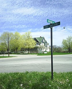
The Husband-Hanchett house at Port Sheldon and Main, a State of Michigan historical site and home of the Jenison Museum. Tiffany Intersection(crop).jpg
The Husband-Hanchett house at Port Sheldon and Main, a State of Michigan historical site and home of the Jenison Museum.

As of the census [2] of 2000, there were 17,211 people, 5,975 households, and 4,863 families residing in the community. The population density was 2,940.8 inhabitants per square mile (1,135.4/km2). There were 6,065 housing units at an average density of 1,036.3 per square mile (400.1/km2). The racial makeup of the community was 98.84% White, 0.49% African American, 0.21% Native American, 0.85% Asian, 0.01% Pacific Islander, 0.53% from other races, and 0.87% from two or more races. Hispanic or Latino of any race were 1.77% of the population.

There were 5,975 households, out of which 39.8% had children under the age of 18 living with them, 73.5% were married couples living together, 5.8% had a female householder with no husband present, and 18.6% were non-families. 16.9% of all households were made up of individuals, and 10.1% had someone living alone who was 65 years of age or older. The average household size was 2.86 and the average family size was 3.24.

In the community, the population was spread out, with 28.9% under the age of 18, 7.8% from 18 to 24, 26.8% from 25 to 44, 24.0% from 45 to 64, and 12.5% who were 65 years of age or older. The median age was 36 years. For every 100 females, there were 93.5 males. For every 100 females age 18 and over, there were 90.5 males.

The median income for a household in the community was $56,426, and the median income for a family was $61,957. Males had a median income of $46,738 versus $28,204 for females. The per capita income for the community was $21,021. About 1.8% of families and 2.5% of the population were below the poverty line, including 3.1% of those under age 18 and 4.3% of those age 65 or over.

Major highways

Major roads

Schools

The majority of the community is in Jenison Public Schools. A small portion is in the Hudsonville Public School District. [9]

Jenison Public Schools facilities include:

Private:

Notable people

Related Research Articles

<span class="mw-page-title-main">Pinson, Alabama</span> City in Alabama, United States

Pinson is a city in Jefferson County near Birmingham, Alabama, United States, northwest of Center Point. As of the 2010 census, the population was 7,163.

<span class="mw-page-title-main">Theodore, Alabama</span> Census-designated place in Alabama, United States

Theodore is an unincorporated area and census-designated place (CDP) in Mobile County, Alabama, United States. The population was 6,270 at the 2020 census. It is a part of the Mobile metropolitan area. Prior to 1900 this area was known as "Clements", but it is now named for William Theodore Hieronymous, a sawmill operator and postmaster.

<span class="mw-page-title-main">Terryville, Connecticut</span> Census-designated place in Plymouth, Connecticut, US

Terryville is a census-designated place (CDP) in Litchfield County, Connecticut, United States, and is the largest village within the town of Plymouth. In the 2010 census, Terryville had a population of 5,387, out of 12,243 in the entire town of Plymouth. The village is named for Eli Terry Jr., the son of the well-known clockmaker Eli Terry Sr. Terryville is also home to the Lock Museum of America. There is a water wheel located in downtown Terryville that is dedicated to the son of Eli Terry Sr.

<span class="mw-page-title-main">Myrtle Grove, Florida</span> Census-designated place in Florida, United States

Myrtle Grove is a census-designated place (CDP) in Escambia County, Florida, United States. The population was 15,870 at the 2010 census. It is part of the Pensacola–Ferry Pass–Brent Metropolitan Statistical Area.

<span class="mw-page-title-main">Kaneohe, Hawaii</span> Census-designated place in Honolulu County, Hawaii, United States

Kaneohe or Kāneʻohe is a census-designated place (CDP) included in the City and County of Honolulu and in Hawaiʻi state District of Koʻolaupoko on the island of Oʻahu. In the Hawaiian language, kāne ʻohe means "bamboo man". According to an ancient Hawaiian story, a local woman compared her husband's cruelty to the sharp edge of cutting bamboo; thus the place was named Kāneʻohe or "bamboo man".

<span class="mw-page-title-main">Lusby, Maryland</span> Census-designated place in Maryland, United States

Lusby is an unincorporated community and census-designated place (CDP) in Calvert County, Maryland, United States. The population of the CDP was 1,835 at the 2010 census. Residents of the Chesapeake Ranch Estates and Drum Point communities also use the Lusby ZIP code designation.

Au Sable is an unincorporated community and census-designated place (CDP) in the U.S. state of Michigan. The population of the CDP was 1,453 at the 2020 census. The community is located within Au Sable Township at the mouth of the Au Sable River along Lake Huron.

<span class="mw-page-title-main">Napoleon, Michigan</span> Census-designated place & unincorporated community in Michigan, United States

Napoleon is an unincorporated community and census-designated place (CDP) in Jackson County in the U.S. state of Michigan. The population of the CDP was 1,258 at the 2010 census. It is located within Napoleon Township.

<span class="mw-page-title-main">Vandercook Lake, Michigan</span> Census-designated place & unincorporated community in Michigan, United States

Vandercook Lake is an unincorporated community and census-designated place (CDP) in Jackson County in the U.S. state of Michigan. The population of the CDP was 4,721 at the 2010 census. It is located within Summit Township.

<span class="mw-page-title-main">Cutlerville, Michigan</span> Census-designated place & unincorporated community in Michigan, United States

Cutlerville is an unincorporated community and census-designated place (CDP) in Kent County in the U.S. state of Michigan. The population was 17,849 as of the 2020 census. The community is located mostly within Byron Township to the west with a smaller portion within Gaines Township to the east.

<span class="mw-page-title-main">Lambertville, Michigan</span> Census-designated place & unincorporated community in Michigan, United States

Lambertville is an unincorporated community and census-designated place (CDP) in Monroe County in the U.S. state of Michigan. The population was 10,433 at the 2020 census. The CDP is located within Bedford Township.

<span class="mw-page-title-main">Allendale, Michigan</span> Census-designated place & unincorporated community in Michigan, United States

Allendale is a census-designated place (CDP) in Ottawa County in the U.S. state of Michigan. The population was 17,579 at the 2010 census. It is located within Allendale Charter Township, occupying approximately the northern two-thirds of the township, from the eastern boundary with the Grand River west along Pierce St., north along 75th Ave., then west along Lake Michigan Drive (M-45) to the western boundary of the township. It is a part of the Grand Rapids-Muskegon-Holland, Michigan combined statistical area, and is an exurb of Grand Rapids, due to its major commuter routes into the city.

<span class="mw-page-title-main">Beechwood, Michigan</span> Census-designated place & Unincorporated community in Michigan, United States

Beechwood is an unincorporated community in Ottawa County in the U.S. state of Michigan. It is a census-designated place (CDP) for statistical purposes, but is not an incorporated municipality. The population was 3,121 at the 2020 census.

<span class="mw-page-title-main">Georgetown Township, Michigan</span> Charter township in Michigan, United States

Georgetown Charter Township is a charter township of Ottawa County in the U.S. state of Michigan. The population was 46,985 at the time of the 2010 census. The city of Hudsonville is adjacent to the township and the unincorporated community of Jenison is within the township, which includes about half the township's population.

<span class="mw-page-title-main">San Felipe Pueblo, New Mexico</span> CDP in New Mexico, United States

San Felipe Pueblo is a census-designated place (CDP) in Sandoval County, New Mexico, United States, and is located 10 miles (16 km) north of Bernalillo. As of the 2000 census, the CDP population was 2,080. It is part of the Albuquerque Metropolitan Statistical Area.

<span class="mw-page-title-main">Nanuet, New York</span> Census-designated place in New York, United States

Nanuet is a hamlet and census-designated place in the town of Clarkstown, Rockland County, New York, United States. The third largest hamlet in Clarkstown, it is located north of Pearl River, south of New City, east of Spring Valley, and west of West Nyack. It is located midway between Manhattan and Bear Mountain, 19 miles (31 km) north and south of each respectively; and 2 miles (3 km) north of the New Jersey border. It has one of three Rockland County stations on New Jersey Transit's Pascack Valley Line. The population of Nanuet was 17,882 at the 2010 census.

<span class="mw-page-title-main">Welcome, North Carolina</span> Census-designated place in North Carolina, United States

Welcome is a census-designated place (CDP) in Davidson County, North Carolina, United States. The population was 4,162 at the 2010 census. It is nationally known as the home of Richard Childress Racing. In addition, Walker and Associates, Inc., a nationwide communication value-add distribution is headquartered here. The town motto is "Welcome to Welcome, A Friendly Place," as posted on the welcoming sign. Neighboring communities and municipalities include Midway, Arcadia, and Lexington.

<span class="mw-page-title-main">Chesterland, Ohio</span> Census-designated place in Ohio, United States

Chesterland is a census-designated place (CDP) in Geauga County, Ohio, United States. As of the 2020 census, the CDP had a population of 7,074.

<span class="mw-page-title-main">Austintown, Ohio</span> Census-designated place in Ohio, United States

Austintown is an unincorporated community and census-designated place within Austintown Township, Mahoning County, Ohio, United States. The population was 29,594 at the 2020 census. Located directly west of Youngstown, it is a suburb of the Youngstown–Warren metropolitan area.

<span class="mw-page-title-main">Ooltewah, Tennessee</span> Census-designated place in Tennessee, United States

Ooltewah is a census-designated place (CDP) in Hamilton County, Tennessee, United States. It is a community near Chattanooga. The population was 684 at the 2020 census. Ooltewah is an enclave in the city of Collegedale.

References

  1. "2020 U.S. Gazetteer Files". United States Census Bureau. Retrieved May 21, 2022.
  2. 1 2 "U.S. Census website". United States Census Bureau . Retrieved January 31, 2008.
  3. U.S. Geological Survey Geographic Names Information System: Jenison, Michigan
  4. 1 2 Wise, David. "Mole-in-Training: How China Tried to Infiltrate the CIA." Washingtonian . July 7, 2012. Retrieved on April 24, 2016.
  5. "ABOUT THE JENISON HISTORICAL ASSOCIATION". jenisonhistory.org. Retrieved January 15, 2019.
  6. History of Ottawa County. 1882. p. 98.
  7. "Ottawa County". Jim Forte Postal History. Retrieved March 29, 2016.
  8. "Census of Population and Housing". Census.gov. Retrieved June 4, 2016.
  9. "2020 CENSUS - SCHOOL DISTRICT REFERENCE MAP: Ottawa County, MI" (PDF). U.S. Census Bureau. p. 1 (PDF p. 2/2). Retrieved October 6, 2022.
  10. "USA Football: It's more than a game". Archived from the original on March 13, 2008. Retrieved March 15, 2008.
  11. Mark Dewey Statistics - The Baseball Cube
  12. Grasmanis Past Stats, Statistics, History, and Awards - databaseFootball.com
  13. "Benny McCoy Statistics and History". Baseball-Reference.com. Retrieved September 25, 2013.
  14. Welcome to Andy Ponstein - Home Archived July 7, 2011, at the Wayback Machine