Related Research Articles
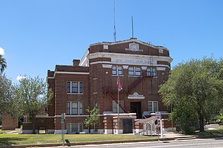
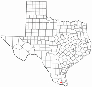
Duval County is a county located in the U.S. state of Texas. As of the 2020 census, its population was 9,831. The county seat is San Diego. The county was founded in 1858 and later organized in 1876. It is named for Burr H. Duval, a soldier in the Texas Revolution who died in the Goliad Massacre.

East China Township is a charter township of St. Clair County in the U.S. state of Michigan. The population was 3,704 at the 2020 Census.
Hume is a town in Allegany County, New York, United States. The population was 2,094 at the 2020 census. The town is on the northern border of Allegany County.
La Blanca is a census-designated place (CDP) in Hidalgo County, Texas, United States. The population was 2,078 at the 2020 United States Census. It is part of the McAllen–Edinburg–Mission Metropolitan Statistical Area.

Sierra Blanca is an unincorporated area in Hudspeth County, Texas, United States. It is also the county seat of the county and the namesake of a census-designated place (CDP) in which it is located. The town is part of the Trans-Pecos region of far West Texas, is located northeast of the Mexican border and is within the Mountain Time Zone. As of the 2020 census, its population was 315.

Delta is a town in Bayfield County, Wisconsin, United States. The population was 273 at the 2010 census. The unincorporated communities of Delta and Pike River are located in the town. The unincorporated community of Sutherland is located partially in the town.

Gurney is a town in Iron County, Wisconsin, United States. The population was 158 at the 2000 census. The unincorporated community of Cedar is located in the town.
Black River is a 15.5-mile-long (24.9 km) river in Alcona County in the U.S. state of Michigan. The main branch rises in northern Harrisville Township at 44°40′46″N83°22′15″W and flows north through Haynes Township and Alcona Township and empties into Lake Huron at 44°48′58″N83°17′57″W at the unincorporated community of Black River.
Eugene is an unincorporated community in Eugene Township, Vermillion County, in the U.S. state of Indiana.
Los Ojuelos is a ghost town near Mirando City in the southeastern part of Webb County, Texas, United States. Before its establishment, Indians camped near the only dependable water source in the semiarid area. The local springs attracted Eugenio Gutiérrez in 1810 and attempted to settle in the area. Frequent Indian attacks forced Gutiérrez to abandon the site. in 1835, Eugenio's son returned to the site and tried to resettle the area but Indian attacks drove him back. In 1850, a company of Texas Rangers were stationed on the site to protect the trade route Laredo - Corpus Christi. In 1857, José María Guerra, grandson of Eugenio Gutiérrez and an ancestor of Laredo businessman Joe A. Guerra, built an irrigation system and a wall around Los Ojuelos to protect from Indian attacks.
Chacon Creek is a small stream of water located in Webb County, Texas, US, which runs through Laredo. The creek is formed 6 miles from Webb and runs southwest for 20 miles until it connects to the Rio Grande. Chacon was dammed in 1951 in east Laredo to form Lake Casa Blanca, a 1,680 acres (6.8 km2) lake. The terrain surrounding the creek is mostly clay. The vegetation surrounding the creek is mostly made up of mesquite, cacti and grasses. Chacon Creek is cross by several highways in Laredo, including United States Route 59, Texas State Highway Loop 20, Texas State Highway Spur 400, Texas State Highway 359 and United States Route 83.
San Ygnacio Creek is a small stream of water located in Webb County, Texas which runs through Laredo, Texas. The creek is formed 11 miles northwest of Laredo, Texas and runs southwest for 12 mi (19 km) until the creek connects to the Lake Casa Blanca. The terrain surrounding the creek is mostly clay. The vegetation surrounding the creek is mostly made up of mesquite, cacti, and grasses. San Ygnacio Creek does not cross any major highway.
The United States Border Patrol operates 71 traffic checkpoints, including 33 permanent traffic checkpoints, near the Mexico–United States border. The stated primary purpose of these inspection stations is to deter illegal immigration and smuggling activities. After the September 11 attacks in 2001, they took on the additional role of terrorism deterrence. These checkpoints are located between 25 and 75 miles of the Mexico–United States border along major U.S. highways; near the southern border of the contiguous United States. Their situation at interior locations allow them to deter illegal activities that may have bypassed official border crossings along the frontier. The checkpoints are divided among nine Border Patrol sectors. There are a number of these checkpoints near the northern border of the contiguous U.S. as well, within 100 miles (160 km) of the Canada–U.S. border.
Hampton was a town in Palo Pinto County, Texas, United States. The town was moved south one mile to a nearby railroad and renamed Gordon in 1881.
Finlay, Texas is a ghost town in Hudspeth County, Texas, United States, 17 miles (27 km) west of Sierra Blanca. The community was named after J.R. Finlay. It had two post offices. One was built in 1890, but never opened. The other was established in 1903. Finlay slowly grew in the early 20th century, but the last population figure was one hundred inhabitants in the 1940s.
Duffau is a ghost town in Erath County, Texas, United States.
Astor is a ghost town in Greeley County, Kansas, United States. It was located at 38.4727937°N 101.9029544°W.
Texas Creek is a medium-sized right tributary of the Fraser River in the Fraser Canyon region of that river's course, located approximately 16 miles down the river from the town of Lillooet. Texas Creek is also the name of the rural neighbourhood in the area of the creek, and also that of the Texas Creek Ranch which is one of the larger holdings.
Casa Blanca is a census-designated place (CDP) in Starr County, Texas, United States. This was a new CDP for the 2010 census, with a population of 54.
Las Pilas is a census-designated place (CDP) in Webb County, Texas, United States. This was a new CDP formed from parts of the Ranchitos Las Lomas CDP prior to the 2010 census, with a population of 28.
References
Municipalities and communities of Duval County, Texas, United States | ||
|---|---|---|
| Cities |  | |
| CDPs | ||
| Other communities | ||
| Ghost towns | ||
| Footnotes | ‡This populated place also has portions in an adjacent county or counties | |
27°48′23″N98°28′22″W / 27.80639°N 98.47278°W
| | This article about a location in Duval County, Texas is a stub. You can help Wikipedia by expanding it. |