Freer, Texas

Last updated

Freer, Texas
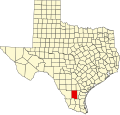
TXMap-doton-Freer.PNG
Location of Freer, Texas
Duval County Freer.svg
Coordinates: 27°52′45″N98°36′58″W / 27.87917°N 98.61611°W / 27.87917; -98.61611
Country United States
State Texas
County Duval
Area
[1]
  Total4.13 sq mi (10.71 km2)
  Land4.12 sq mi (10.68 km2)
  Water0.01 sq mi (0.03 km2)
Elevation
[2]
518 ft (158 m)
Population
 (2020)
  Total2,461
  Density600/sq mi (230/km2)
Time zone UTC-6 (Central (CST))
  Summer (DST) UTC-5 (CDT)
ZIP code
78357
Area code 361
FIPS code 48-27432 [3]
GNIS feature ID2410544 [2]
Website www.freertx.org

Freer is a city in Duval County, Texas, United States. Its population was 2,461 at the 2020 census. [4]

Contents

Oil well pump exhibit in Freer Oil well exhibit in Freer IMG 0966.JPG
Oil well pump exhibit in Freer
Modern oil derrick east of Freer off U.S. Route 59 (Future Interstate 69W) Oil derrick east of Freer, TX IMG 0969.JPG
Modern oil derrick east of Freer off U.S. Route 59 (Future Interstate 69W)

Geography

Brush Country Bank in Freer Brush Country Bank .MVI 2747.jpg
Brush Country Bank in Freer

Freer is located in northwestern Duval County at 27°52′45″N98°36′58″W / 27.87917°N 98.61611°W / 27.87917; -98.61611 (27.879156, –98.616237). [5] U.S. Route 59 passes east–west through the city as Riley Street. Once outside the city limits, US 59 leads northeast 68 miles (109 km) to Beeville and southwest 59 miles (95 km) to Laredo. Texas State Highway 16 (Norton Avenue) crosses US 59 in the center of town and leads north 111 miles (179 km) to San Antonio and southwest 92 miles (148 km) to Zapata on the Rio Grande. Texas State Highway 44 passes through the center of Freer on Riley Street with US 59, but leads east 25 miles (40 km) to San Diego, the Duval County seat, and 35 miles (56 km) to Alice, and west 47 miles (76 km) to Interstate 35 at Encinal.

According to the United States Census Bureau, Freer has a total area of 4.1 square miles (10.5 km2), of which 0.012 square miles (0.03 km2), or 0.30%, is covered by water. [6]

Demographics

Historical population
CensusPop.Note
1940 2,346
1950 2,280−2.8%
1960 2,73419.9%
1970 2,8042.6%
1980 3,21314.6%
1990 3,2711.8%
2000 3,241−0.9%
2010 2,818−13.1%
2020 2,461−12.7%
U.S. Decennial Census [7]

2020 census

Freer racial composition [4]
(NH = Non-Hispanic) [lower-alpha 1]
RaceNumberPercentage
White (NH)31712.88%
Black or African American (NH)40.16%
Native American or Alaska Native (NH)50.2%
Asian (NH)240.98%
Some other race (NH)10.04%
Mixed/multiracial (NH)923.74%
Hispanic or Latino 2,01882.0%
Total2,461

As of the 2020 United States census, 2,461 people, 809 households, and 663 families were residing in the city.

2000 census

As of the census [3] of 2000, 3,241 people, 1,111 households, and 845 families resided in the city. The population density was 804.3 inhabitants per square mile (310.5/km2). The 1,334 housing units had an average density of 331.1 per square mile (127.8/km2). The racial makeup of the city was 80.59% White, 0.46% African American, 0.68% Native American, 0.25% Asian, 14.87% from other races, and 3.15% from two or more races. Hispanics or Latinos of any race were 77.38% of the population.

Of the 1,111 households, 42.0% had children under 18 living with them, 56.3% were married couples living together, 14.3% had a female householder with no husband present, and 23.9% were not families. About 21.5% of all households were made up of individuals, and 9.2% had someone living alone who was 65 or older. The average household size was 2.92, and the average family size was 3.40.

In the city, the age distribution was 33.1% under 18, 9.8% from 18 to 24, 26.3% from 25 to 44, 19.9% from 45 to 64, and 10.9% who were 65 or older. The median age was 30 years. For every 100 females, there were 95.9 males. For every 100 females age 18 and over, there were 96.2 males.

The median income for a household in the city was $25,078, and for a family was $26,475. Males had a median income of $26,789 versus $17,159 for females. The per capita income for the city was $11,457. About 18.4% of families and 21.6% of the population were below the poverty line, including 26.5% of those under age 18 and 25.4% of those age 65 or over.

Education

The city is served by the Freer Independent School District.

Notable people

Media

KBRA-FM radio at 95.9 MHz.

Climate

The climate in this area is characterized by hot, humid summers and generally mild to cool winters. According to the Köppen climate classification, Freer has a humid subtropical climate, Cfa on climate maps. [10]

Climate data for Freer, Texas (1991–2020 normals, extremes 1962–2008, 2011–present)
MonthJanFebMarAprMayJunJulAugSepOctNovDecYear
Record high °F (°C)95
(35)
101
(38)
103
(39)
107
(42)
111
(44)
116
(47)
110
(43)
111
(44)
112
(44)
102
(39)
97
(36)
95
(35)
116
(47)
Mean daily maximum °F (°C)66.2
(19.0)
71.2
(21.8)
77.7
(25.4)
84.4
(29.1)
90.7
(32.6)
94.8
(34.9)
97.3
(36.3)
98.4
(36.9)
92.0
(33.3)
85.3
(29.6)
75.1
(23.9)
67.8
(19.9)
83.4
(28.6)
Daily mean °F (°C)54.7
(12.6)
59.6
(15.3)
66.1
(18.9)
72.2
(22.3)
79.1
(26.2)
83.6
(28.7)
85.5
(29.7)
85.9
(29.9)
80.5
(26.9)
73.6
(23.1)
63.8
(17.7)
56.5
(13.6)
71.8
(22.1)
Mean daily minimum °F (°C)43.3
(6.3)
48.0
(8.9)
54.6
(12.6)
60.0
(15.6)
67.4
(19.7)
72.3
(22.4)
73.7
(23.2)
73.3
(22.9)
68.9
(20.5)
61.9
(16.6)
52.5
(11.4)
45.3
(7.4)
60.1
(15.6)
Record low °F (°C)12
(−11)
14
(−10)
20
(−7)
35
(2)
41
(5)
54
(12)
60
(16)
58
(14)
43
(6)
36
(2)
20
(−7)
16
(−9)
12
(−11)
Average precipitation inches (mm)1.25
(32)
1.31
(33)
1.92
(49)
2.08
(53)
2.80
(71)
3.07
(78)
2.44
(62)
2.45
(62)
3.35
(85)
1.82
(46)
1.42
(36)
1.24
(31)
25.15
(639)
Average snowfall inches (cm)0.0
(0.0)
0.0
(0.0)
0.0
(0.0)
0.0
(0.0)
0.0
(0.0)
0.0
(0.0)
0.0
(0.0)
0.0
(0.0)
0.0
(0.0)
0.0
(0.0)
0.0
(0.0)
0.0
(0.0)
0.0
(0.0)
Average precipitation days (≥ 0.01 in)3.34.24.03.63.94.42.83.05.73.42.93.945.1
Average snowy days (≥ 0.1 in)0.00.00.00.00.00.00.00.00.00.00.00.00.0
Source: NOAA [11] [12]

Notes

  1. Note: the US Census treats Hispanic/Latino as an ethnic category. This table excludes Latinos from the racial categories and assigns them to a separate category. Hispanics/Latinos can be of any race. [8] [9]

Related Research Articles

<span class="mw-page-title-main">McMullen County, Texas</span> County in Texas, United States

McMullen County is a county located in the U.S. state of Texas. As of the 2020 census, its population was 600, making it the fourth-least populous county in Texas. Its county seat is Tilden. The county was established from parts of Bexar County, Atascosa County, and Live Oak County in 1858 and later organized in 1877. It is named for John McMullen, founder of a colony in Texas. The McMullen County Courthouse was designed by the architect W.C. Stephenson, originally from Buffalo, New York. Stephenson also designed some 50 buildings in Beeville, including the Bee County Courthouse.

<span class="mw-page-title-main">Live Oak County, Texas</span> County in Texas, United States

Live Oak County is a county in the U.S. state of Texas. It was named for its native groves of live oak. George West is its county seat. Its population was 11,335 in the 2020 census.

<span class="mw-page-title-main">Jim Hogg County, Texas</span> County in Texas, United States

Jim Hogg County is a county located in the U.S. state of Texas. As of the 2020 census, the population was 4,838. Its county seat is Hebbronville. The county is named for James Stephen Hogg, the governor of Texas from 1891 to 1895.

<span class="mw-page-title-main">Duval County, Texas</span> County in Texas, United States

Duval County is a county located in the U.S. state of Texas. As of the 2020 census, its population was 9,831. The county seat is San Diego. The county was founded in 1858 and later organized in 1876. It is named for Burr H. Duval, a soldier in the Texas Revolution who died in the Goliad Massacre.

<span class="mw-page-title-main">Diboll, Texas</span> City in Texas, United States

Diboll is a city in Angelina County, Texas, United States. The population was 4,457 at the 2020 census. Diboll is named for J. C. Diboll, a local timber salesman.

<span class="mw-page-title-main">Jourdanton, Texas</span> City in Texas, United States

Jourdanton is a city in and the county seat of Atascosa County, Texas, United States. The population is 4,094. It is part of the San Antonio metropolitan statistical area. The mayor is Robert "Doc" Williams. The city manager is Bobby J. Martinez. The police chief is Eric Kaiser. The fire chief is Jay Fojtik.

<span class="mw-page-title-main">Round Mountain, Texas</span> Town in Blanco County, Texas, United States

Round Mountain is a town in Blanco County, Texas, United States. The population was 101 at the 2020 census.

<span class="mw-page-title-main">Dickens, Texas</span> City in Texas, United States

Dickens is a city in and the county seat of Dickens County, Texas, United States. The population was 286 at the 2010 census, down from 332 at the 2000 census.

Benavides is a city in Duval County, Texas, United States. The population was 1,183 at the 2020 census.

<span class="mw-page-title-main">Eastland, Texas</span> City in Texas, United States

Eastland is a city in Eastland County, Texas, United States. The population was 3,609 at the 2020 census. It is the county seat of Eastland County.

<span class="mw-page-title-main">Hamilton, Texas</span> City in Texas, United States

Hamilton is a city in and the county seat of Hamilton County, Texas, United States, located in the state's central region. Its population was 2,895 at the 2020 census.

<span class="mw-page-title-main">Kountze, Texas</span> City in Texas, United States

Kountze is a city in and the county seat of Hardin County, Texas, United States. The population was 1,981 at the 2020 census. The city is part of the Beaumont–Port Arthur Metropolitan Statistical Area.

<span class="mw-page-title-main">Malakoff, Texas</span> City in Texas, United States

Malakoff is a city in Henderson County, Texas, United States. The population was 2,179 at the 2020 census. The city is named after a Russian fort of Malakoff, which played a pivotal role during the siege of Sevastopol during the Crimean War.

<span class="mw-page-title-main">Falls City, Texas</span> City in Texas, United States

Falls City is a city in Karnes County, Texas, United States. The population was 514 at the 2020 census. Falls City is near the location of a uranium tailings disposal cell, completed in 1994 under the terms of the 1978 Uranium Mill Tailings Radiation Control Act. The early settlers, predominantly Polish Catholics, founded the Holy Trinity Catholic Church in 1902.

<span class="mw-page-title-main">George West, Texas</span> City in Texas, United States

George West is a city in Live Oak County, Texas, United States, and named for cattle rancher George Washington West. The population was 2,171 at the 2020 census. It is the county seat of Live Oak County. George West was named the "storytelling capital of Texas" in 2005 by the Texas Senate; and it hosts the George West Storyfest, a festival that features storytelling, cowboy poetry, and music. Numerous ranches surround George West.

<span class="mw-page-title-main">Natalia, Texas</span> City in Texas, United States

Natalia is a city in Medina County, Texas, United States. The population was 1,202 at the 2020 census. It was founded in 1912 and was named after Natalie Pearson Nicholson, daughter of Frederick Stark Pearson, engineer, designer and builder of the Medina Dam.

<span class="mw-page-title-main">San Saba, Texas</span> City in Texas, United States

San Saba is a city located in, and the county seat of, San Saba County, Texas, United States. It was settled in 1854 and named for its location on the San Saba River. Its population was 3,099 at the 2010 census.

<span class="mw-page-title-main">Horseshoe Bay, Texas</span> City in Texas, United States

Horseshoe Bay is a city in Llano and Burnet counties in the U.S. state of Texas.

<span class="mw-page-title-main">San Diego, Texas</span> City in Texas, United States

San Diego is a city in Duval and Jim Wells counties, Texas, United States. The population was 3,748 at the 2020 census and 4,488 at the 2010 census. It is located primarily in Duval County, of which it is the county seat.

<span class="mw-page-title-main">Gorman, Texas</span> City in Texas, United States

Gorman is a city in Eastland County, Texas, United States. Its population was 976 at the 2020 census, down from 1,083 at the 2010 census.

References

  1. "2019 U.S. Gazetteer Files". United States Census Bureau. Retrieved August 7, 2020.
  2. 1 2 U.S. Geological Survey Geographic Names Information System: Freer, Texas
  3. 1 2 "U.S. Census website". United States Census Bureau . Retrieved January 31, 2008.
  4. 1 2 "Explore Census Data". data.census.gov. Retrieved May 19, 2022.
  5. "US Gazetteer files: 2010, 2000, and 1990". United States Census Bureau. February 12, 2011. Retrieved April 23, 2011.
  6. "Geographic Identifiers: 2010 Demographic Profile Data (G001): Freer city, Texas". American Factfinder. U.S. Census Bureau. Archived from the original on February 13, 2020. Retrieved January 8, 2016.
  7. "Census of Population and Housing". Census.gov. Retrieved June 4, 2015.
  8. https://www.census.gov/ [ not specific enough to verify ]
  9. "About the Hispanic Population and its Origin". www.census.gov. Retrieved May 18, 2022.
  10. Climate Summary for Freer, Texas
  11. "NOWData - NOAA Online Weather Data". National Oceanic and Atmospheric Administration. Retrieved March 1, 2024.
  12. "Summary of Monthly Normals 1991-2020". National Oceanic and Atmospheric Administration. Retrieved March 1, 2024.