
Pembrokeshire is a county in the south-west of Wales. It is bordered by Carmarthenshire to the east, Ceredigion to the northeast, and the rest by sea. The county is home to Pembrokeshire Coast National Park. The Park occupies more than a third of the area of the county and includes the Preseli Hills in the north as well as the 190-mile (310 km) Pembrokeshire Coast Path.

Pembroke Castle is a medieval castle in the centre of Pembroke, Pembrokeshire in Wales. The castle was the original family seat of the Earldom of Pembroke. A Grade I listed building since 1951, it underwent major restoration during the early 20th century.

Milford Haven is a town and community in Pembrokeshire, Wales. It is situated on the north side of the Milford Haven Waterway, an estuary forming a natural harbour that has been used as a port since the Middle Ages. Founded in 1790 by Sir William Hamilton, designed to a grid pattern, it was originally intended to be a whaling centre, though by 1800 it was developing as a Royal Navy dockyard which it remained until the dockyard was transferred to Pembroke in 1814. It then became a commercial dock, with the focus moving in the 1960s, after the construction of an oil refinery built by Esso, to logistics for fuel oil and liquid gas. By 2010, the town's port had become the fourth largest in the United Kingdom in terms of tonnage, and continues its important role in the United Kingdom's energy sector with several oil refineries and one of the biggest LNG terminals in the world.

Pembroke Dock is a town and a community in Pembrokeshire, South West Wales, 3 miles (4.8 km) northwest of Pembroke on the banks of the River Cleddau. Originally Paterchurch, a small fishing village, Pembroke Dock town expanded rapidly following the construction of the Royal Navy Dockyard in 1814. The Cleddau Bridge links Pembroke Dock with Neyland.

Carew Castle is a castle in the civil parish of Carew in Pembrokeshire, Wales. The famous Carew family, who take their name from this site, still own the castle and lease it to the Pembrokeshire Coast National Park for administration.
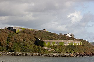
Fort Hubberstone, on the west side of Milford Haven, Pembrokeshire, is a Grade II* Listed Building which belongs to a series of forts built as part of the inner line of defence of the Haven following the Royal Commission on the Defence of the United Kingdom. Together with Popton Fort on the opposite shore, it provided an interlocking field of fire, and represented the last layer of defence before reaching the Royal Naval dockyard at Pembroke Dock. Construction began in 1860 and was completed in 1863 at a cost of £55,000. It is a large battery, with eleven guns in casemates, eight in an open battery above, with another nine in an open flank battery, and a large barracks to the rear. It is a D-shaped structure, with a bomb-proof roof which protected the barracks and other buildings from mortar projectiles. On its landward side, it was protected by a deep ditch, and on the seaward side by a counter-scarp gallery. The associated casemate battery is located further down the headland and separated from the fort.

The 1648 Second English Civil War is one in a series of connected conflicts in the kingdoms of England, incorporating Wales, Scotland, and Ireland. Known collectively as the 1638 to 1651 Wars of the Three Kingdoms, others include the Irish Confederate Wars, the 1638 to 1640 Bishops' Wars, and the Cromwellian conquest of Ireland.

Stack Rock Fort is a fort built on a small island in the Milford Haven Waterway, Pembrokeshire. A 3-gun fort was built between 1850 and 1852, and then upgraded in 1859 with a new building that completely encased the original gun tower. It is now a Grade II* listed building and a Scheduled Monument.

Milford Haven Waterway is a natural harbour in Pembrokeshire, Wales. It is a ria or drowned valley which was flooded at the end of the last ice age. The Daugleddau estuary winds west to the sea. As one of the deepest natural harbours in the world, it is a busy shipping channel, trafficked by ferries from Pembroke Dock to Ireland, oil tankers and pleasure craft. Admiral Horatio Nelson, visiting the haven with the Hamiltons, described it as the next best natural harbour to Trincomalee in Ceylon and "the finest port in Christendom". Much of the coastline of the Waterway is designated as a Site of Special Scientific Interest, listed as Milford Haven Waterway SSSI.
The River Cleddau consists of the Eastern and Western Cleddau rivers in Pembrokeshire, west Wales. They unite to form the Daugleddau estuary and the important harbour of Milford Haven.

Limerick, in western Ireland was the scene of two sieges during the Irish Confederate Wars. The second and largest of these took place during the Cromwellian conquest of Ireland in 1650–51. Limerick was one of the last fortified cities held by an alliance of Irish Irish Confederates and Royalists against the forces of the English Parliament. Its garrison, led by Hugh Dubh O'Neill, surrendered to Henry Ireton after a protracted and bitter siege. Over 2,000 soldiers of Cromwell's New Model Army were killed at Limerick, and Henry Ireton, Cromwell's son-in-law, died of plague.

Major General Rowland Laugharne was a member of the Welsh gentry, and a prominent soldier during the Wars of the Three Kingdoms, in which he fought on both sides.

Steynton or Stainton is a parish in the county of Pembrokeshire, Wales, formerly in the hundred of Rhôs and now an area of Milford Haven and in the Community of. The parish includes the hamlet of Dreenhill, near Haverfordwest. The parish population is about 3,000.

Roch Castle is a 12th-century castle, located at Roch near Haverfordwest, Wales.
The town of Milford Haven was founded in 1793 by Sir William Hamilton, who initially invited Quaker whalers from Nantucket to live in his town, and then, in 1797, the Navy Board to create a dockyard for building warships.
Tenby Castle was a fortification standing on a headland separated by an isthmus from the town of Tenby, Pembrokeshire, Wales. The remaining stone structure dates from the 13th century but there are mentions of the castle from as early as 1153. It is a Grade II* listed building.
Sir Hugh Owen, 1st Baronet was a Welsh politician who sat in the House of Commons variously between 1626 and 1660. He sided originally with the Parliamentarian side in the English Civil War, but the strength of his allegiance was in doubt.

During the English Civil War (1642–1651), Bristol was a key port on the west coast of England and considered strategically important by both Royalists and Parliamentarians. Initially, the leadership of Bristol wanted to keep the city neutral in the conflict. In 1642, city officials implored Thomas Essex not to occupy the city with his Parliamentarian forces. The city was weakly defended, and Essex entered without much resistance. During the conflict, Bristol was used as a receiving point for the Royalists to accept reinforcements from Ireland. The town was well fortified by the Frome and Avon rivers, as well as a medieval castle, which had been bought by the corporation when the First English Civil War broke out in 1642, and during the Parliamentary defense, earthen artillery forts.

Scoveston Fort, on the northern shore of Milford Haven, Pembrokeshire, Wales, U.K., is a Grade II Listed Building which belongs to a series of forts built as part of the inner line of defence of the Haven following the Royal Commission on the Defence of the United Kingdom. Built on high ground to the north east of the town of Milford Haven, it commands excellent views of the surrounding countryside, and was the only fort around the Haven to be built inland.
RNMD Milford Haven is a decommissioned Royal Naval Armaments Depot located on the north shore of Milford Haven between Milford Haven and Llanstadwel in the County of Pembrokeshire, Wales. The area is known as Newton Noyes.

