
Austria is a predominantly mountainous country in Central Europe, approximately between Germany, Italy and Hungary. It has a total area of 83,871 square kilometres (32,383 sq mi).
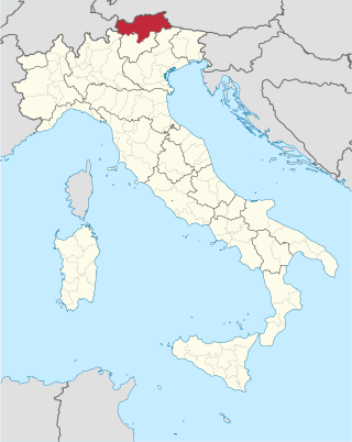
Tyrol is an Austrian federal state. It comprises the Austrian part of the historical Princely County of Tyrol. It is a constituent part of the present-day Euroregion Tyrol–South Tyrol–Trentino. The capital of Tyrol is Innsbruck.
South Tyrol is an autonomous province in northern Italy. An English translation of the official German and Italian names could be the Autonomous Province of Bolzano – South Tyrol, reflecting the multilingualism and different naming conventions in the area. Together with the autonomous province of Trento, South Tyrol forms the autonomous region of Trentino-Alto Adige/Südtirol. The province is the northernmost of Italy, the second largest with an area of 7,400 square kilometres (2,857 sq mi), and has a total population of about 534,000 inhabitants as of 2021. Its capital and largest city is Bolzano.

The Silvretta Alps are a mountain range of the Central Eastern Alps shared by Tirol, Vorarlberg and Graubünden (Switzerland). The Austrian states of Tirol and Vorarlberg are connected by a pass road. The majority of the peaks are elevated above three thousand metres and are surrounded by glaciers. Thus, the area is also known as the "Blue Silvretta".

Hochfilzen is a town and municipality in the Kitzbühel district of the Austrian state of Tyrol. It is located in the Pillersee valley 5 km east of Fieberbrunn. Population was 1,147 in 2016.

Kitzbühel is a medieval town situated in the Kitzbühel Alps along the river Kitzbüheler Ache in Tyrol, Austria, about 100 km (62 mi) east of the state capital Innsbruck and is the administrative centre of the Kitzbühel district. Kitzbühel is one of the most famous and exclusive ski resorts in the world. It is frequented primarily by the international high society and has the most expensive real estate in Austria. The proximity to Munich has made it a preferred location for vacation homes among the German elite.

The Bavarian Alps is a collective name for several mountain ranges of the Northern Limestone Alps within the German state of Bavaria.

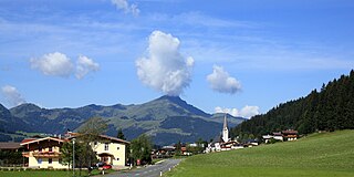
The Kitzbühel Alps are a mountain range of the Central Eastern Alps surrounding the town of Kitzbühel in Tyrol, Austria. Geologically they are part of the western slate zone.
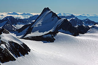
The Ötztal Alps are a mountain range in the Central Eastern Alps, in the State of Tyrol in western Austria and the Province of South Tyrol in northern Italy.

The Eastern Alps are usually defined as the area east of a line from Lake Constance and the Alpine Rhine valley, up to the Splügen Pass at the Alpine divide, and down the Liro River to Lake Como in the south. The peaks and mountain passes are lower than the Western Alps, while the range itself is broader and less arched.

Heiligenblut am Großglockner is a municipality in the district of Spittal an der Drau in Carinthia, Austria.
Tristach is a municipality in the district of Lienz in the Austrian state of Tyrol.

The Lofer Mountains or Loferer Mountains are a mountain range in the Northern Limestone Alps in the Eastern Alps of central Europe. They are located in Austria in the federal states of Tyrol and Salzburg. The Lofers are separated from the Leogang Mountains to the southeast by a 1,202 m-high saddle known as the Römersattel.

SOIUSA is a proposal for a new classification system of the Alps from the geographic and toponomastic point of view. It was designed by Sergio Marazzi, Italian researcher and author of the Orographic Atlas of the Alps SOIUSA. His book was presented with the patronage of the Italian Alpine Club on 23 Jan 2006, but has yet to receive any formal acceptance.

The Wildseeloder is a 2,119-metre-high (6,952 ft) mountain in the eastern Kitzbühel Alps in Tyrol, Austria. The valley base for the Wildseeloder is Fieberbrunn in the Pillersee valley. On its northern slopes is a ski area. The summit, which has no lifts up to it, is a popular ski touring destination in winter. West of the Wildseeloder is a lake, the Wildsee, in a cirque hollow. The Wildseeloderhaus stands on its shore. The easiest ascent to the Wildseeloder runs from Fieberbrunn to the north, over the Lärchfilzkogel past the Wildseeloderhaus.
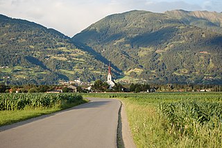
The Pillersee Valley is a valley in the district of Kitzbühel in the Austrian state of Tyrol, on the border with Salzburg state.
The Unterberg is a 1,187 m high, wooded, conical mountain peak above the Pillersee valley, near St. Ulrich am Pillersee and St. Jakob im Haus, Kitzbühel District, in Austria.

The Villgraten Mountains or Deferegg Alps, also called the Defreggen Mountains are a subgroup of the Austrian Central Alps within the Eastern Alps of Europe. Together with the Ankogel Group, the Goldberg Group, the Glockner Group, the Schober Group, the Kreuzeck Group, the Granatspitze Group, the Venediger Group and the Rieserferner Group, the Villgraten Mountains are part of the major mountain range, the High Tauern. Their highest summit is the Weiße Spitze with a height of 2,962 m above sea level (AA).

A double summit, double peak, twin summit, or twin peak is a mountain or hill that has two summits, separated by a col or saddle.

