
The Piltdown Man was a paleoanthropological fraud in which bone fragments were presented as the fossilised remains of a previously unknown early human. Although there were doubts about its authenticity virtually from the beginning, the remains were still broadly accepted for many years, and the falsity of the hoax was only definitively demonstrated in 1953. An extensive scientific review in 2016 established that amateur archaeologist Charles Dawson was responsible for the fraudulent evidence.

Uckfield is a town in the Wealden District of East Sussex in South East England. The town is on the River Uck, one of the tributaries of the River Ouse, on the southern edge of the Weald.

Crowborough is a town and civil parish in East Sussex, England, in the Weald at the edge of Ashdown Forest in the High Weald Area of Outstanding Natural Beauty, 7 miles (11 km) south-west of Royal Tunbridge Wells and 33 miles (53 km) south of London. It had a population 20,607 at the 2011 Census.

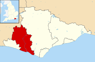
Wealden is a local government district in East Sussex, England. Its council is based in Hailsham, the district's second largest town. The district also includes the towns of Crowborough, Polegate and Uckfield, along with numerous villages and surrounding rural areas. The district's name comes from the Weald, the landscape and ancient woodland which occupies much of the centre and north of the area.

Tandridge is a local government district in east Surrey, England. Its council is based in Oxted, although the largest settlement is Caterham; other notable settlements include Warlingham, Godstone and Lingfield. In mid-2019, the district had an estimated population of 88,129.

Rother is a local government district in East Sussex, England. Its council is based in Bexhill-on-Sea. The district is named after the River Rother which flows within its boundaries.
Lewes is a local government district in East Sussex, England. The district is named after the town of Lewes. The largest town is Seaford. The district also includes the towns of Newhaven, Peacehaven and Telscombe and numerous villages and surrounding rural areas. The council meets in Lewes and has its main offices in Newhaven.

Isfield is a small village and civil parish in the Wealden District of East Sussex in England, located north-east of Lewes.
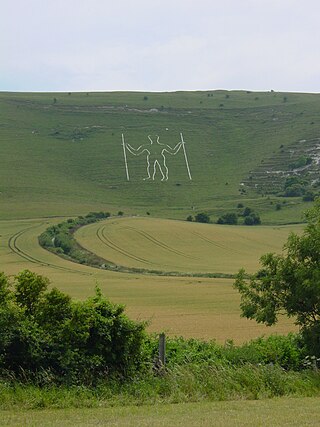
Long Man is a civil parish in the Wealden District of East Sussex, England, which includes the villages of Wilmington, Milton Street and Folkington. The parish is named after the Long Man of Wilmington, a 69.2-metre (227 ft) chalk figure in the parish.

Wealden was a constituency in East Sussex in the House of Commons of the UK Parliament. It was represented by members of the Conservative Party since its creation in 1983. Its final MP from 2015 to 2024, Nus Ghani, is the first Muslim woman to be elected as a Conservative member of Parliament.

Buxted is a village and civil parish in the Wealden district of East Sussex in England. The parish is situated on the Weald, north of Uckfield; the settlements of Five Ash Down, Heron's Ghyll and High Hurstwood are included within its boundaries. At one time its importance lay in the Wealden iron industry, and later it became commercially important in the poultry and egg industry.

Newick is a village, civil parish and electoral ward in the Lewes District of East Sussex, England. It is located on the A272 road six miles (9.7 km) east of Haywards Heath.

Fletching is a village and civil parish in the Wealden District of East Sussex, England. It is located three miles (4.8 km) to the north-west of Uckfield, near one of the entrances to Sheffield Park. The A272 road crosses the parish. The settlement of Piltdown is part of the parish. The Piltdown Man discovery in 1912 was thought to be the missing link between humans and apes. The significance of the specimen remained controversial until, amidst great publicity, and much embarrassment in scientific circles, it was exposed in 1953 as a forgery thought to have been committed by Charles Dawson.

Danehill is a village in East Sussex, England.

Frant is a village and civil parish in the Wealden District of East Sussex, England, on the Kentish border about three miles (5 km) south of Royal Tunbridge Wells.
Wealden District Council in East Sussex, England is elected every four years. From 2003 until the election in 2019, 55 councillors were elected from 35 wards. From 2019, 45 councillors have been elected from 41 wards.

Litlington is a village and former civil parish, now in the parish of Cuckmere Valley, in the Wealden district, in the county of East Sussex, England. It is focussed 3 miles (4.8 km) ENE of Seaford on the south coast. It was in a roughly square parish of dramatic chalkland that extends down to a natural coastline of pebble beach, Cuckmere Haven. In 1961 the parish had a population of 117. On 1 April 1990 the parish was abolished and merged with Lullington and Westdean to form Cuckmere Valley.

East Grinstead and Uckfield is a constituency of the House of Commons in the UK Parliament. Further to the completion of the 2023 Periodic Review of Westminster constituencies, it was first contested at the 2024 general election. It is currently represented by Mims Davies, who was previously MP for Mid Sussex, until the 2024 election.

