Related Research Articles

Blossom is a town in Lamar County, Texas, United States. The population was 1,494 at the 2010 census.
Gilman is a town in Pierce County, Wisconsin, United States. The population was 772 at the 2000 census. The unincorporated communities of Olivet and Viking are partially located in the town.

Independence is an unincorporated community in Washington County, Texas, United States. Located twelve miles northeast of Brenham, it was founded in 1835 in Austin's colony of Anglo-Americans. It became a Baptist religious and educational center of the Republic of Texas. In 1845 it became the first site of Baylor University and the University of Mary Hardin-Baylor.

Cooper Lake State Park is a Texas State Park about three miles (5 km) south of Cooper, Texas. The park is situated on Jim Chapman Lake, formerly known as Cooper Lake. There are actually two geographically separate units; the Doctors Creek unit 33°20′54″N95°40′08″W is located on the north side of the lake, in Delta County, while the South Sulphur unit 33°17′49″N95°39′35″W is located on the south side of the lake, in Hopkins County.
Chopawamsic Creek is a 6.8-mile-long (10.9 km) tributary of the Potomac River in Prince William and Stafford counties, Virginia. Chopawamsic Creek is formed by the confluence of the North and South Branches of Chopawamsic Creek and empties into the Potomac River south of Quantico at the Marine Corps Base Quantico's Air Station. Breckenridge Reservoir lies at the stream's confluence with the North and South Branches. Along with its North Branch, Chopawamsic Creek forms part of the boundary between Prince William and Stafford counties. The North Branch flows through part of the Chopawamsic Backcountry Area in Prince William Forest Park.
Cauldron Dome is a tuya in the Mount Cayley volcanic field, British Columbia, Canada. Cauldron Dome is made of coarsely plagioclase-orthophyroxene-phyric andesite lava flows and last erupted during the Holocene. It is in the Garibaldi Volcanic Belt, a portion of the Canadian Cascade Arc.
CKGY-FM is a radio station located in Red Deer, Alberta. Owned by Stingray Group, it broadcasts a country music format branded as Real Country 95.5
Inuujarvik Territorial Park is a park in Kivalliq Region, Nunavut, Canada. It is located along the shore of Baker Lake.

Fombell is an unincorporated community that includes both Franklin Township and Marion Township, Beaver County, Pennsylvania, United States. Its U.S. postal zip code is 16123. Its elevation ranges from 879 feet (268 m) along the creek to 1280 feet on top of the hills, and it is located at 40°48′34″N80°12′6″W.
KTMR is a radio station licensed to Converse, Texas serving nearby San Antonio as a Spanish radio station playing Christian music and talk programs. It is currently under ownership of SIGA Broadcasting Corporation.

Dołgie is a village in the administrative district of Gmina Biały Bór, within Szczecinek County, West Pomeranian Voivodeship, in north-western Poland. It lies approximately 13 kilometres (8 mi) south of Biały Bór, 12 km (7 mi) north-east of Szczecinek, and 153 km (95 mi) east of the regional capital Szczecin.
Phillips Corner is a former settlement in Butte County, California, United States. It was located 1.5 miles (2.4 km) east-southeast of Honcut. Its post office was moved to Honcut in 1878.

Spanish Flat is an unincorporated community in El Dorado County, California. It is located 4 miles (6 km) north of Chili Bar, at an elevation of 2431 feet.
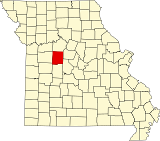
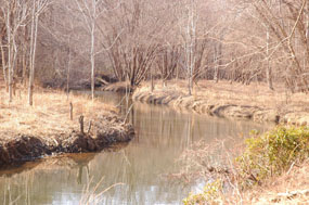
Newland is an unincorporated community in northeast Pettis County, in the U.S. state of Missouri. The community is on Missouri Route EE approximately eight miles northeast of Sedalia.

South Carlsbad State Beach is a beach located in Carlsbad, California.
Wirt is an unincorporated community in Jefferson County, Indiana, in the United States.
The Ogre is a summit in Idaho County, Idaho, in the United States. It forms part of the Seven Devils Mountains. With an elevation of 9,222 feet (2,811 m), The Ogre is the 271st highest summit in the state of Idaho.
Devils Throne is a summit in Idaho County, Idaho, in the United States. It forms part of the Seven Devils Mountains. With an elevation of 9,045 feet (2,757 m), Devils Throne is the 312th highest summit in the state of Idaho.
Devils Tooth is a summit in Idaho County, Idaho, in the United States. With an elevation of 7,598 feet (2,316 m), Devils Tooth is the 762nd highest summit in the state of Idaho.
Hadley Township is a township in St. Louis County, in the U.S. state of Missouri. Its population was 34,816 as of the 2010 census.
References
References:
William A Owens, This Stubborn Soil, New York, Scribner [1966]
