
Garrett County is the westernmost county of the U.S. state of Maryland completely within the Appalachian Mountains. As of the 2020 census, the population was 28,806, making it the third-least populous county in Maryland. Its county seat is Oakland. The county was named for John Work Garrett (1820–1884), president of the Baltimore and Ohio Railroad. Created from Allegany County in 1872, it was the last county to be formed in the state.

Moorefield is a town and the county seat of Hardy County, West Virginia, United States. It is located at the confluence of the South Branch Potomac River and the South Fork South Branch Potomac River. Moorefield was originally chartered in 1777; it was named for Conrad Moore, who owned the land upon which the town was laid out. The population was 2,527 at the 2020 census.

Paw Paw is a town in Morgan County, West Virginia, United States. The population was 410 at the 2020 census. The town is known for the nearby Paw Paw Tunnel. Paw Paw was incorporated by the Circuit Court of Morgan County on April 8, 1891, and named after pawpaw, a wild fruit that grows in abundance throughout this region. Paw Paw is the westernmost incorporated community in Morgan County, and the Hagerstown-Martinsburg, MD-WV Metropolitan Statistical Area.

The Eastern Panhandle is the eastern of the two panhandles in the U.S. state of West Virginia; the other is the Northern Panhandle. It is a small stretch of territory in the northeast of the state, bordering Maryland and Virginia. Some sources and regional associations only identify the Eastern Panhandle as being composed of Morgan, Berkeley, and Jefferson counties. Berkeley and Jefferson counties are geographically located in the Shenandoah Valley. West Virginia is the only U.S. state with two panhandles.

Winchester, VA–WV MSA is a U.S. metropolitan statistical area (MSA) as defined by the United States Office of Management and Budget (OMB) as of June, 2003. This should not be confused with the City of Winchester, Virginia, the most populous community within this MSA. The population of the MSA as the 2015 U.S. Census Bureau estimates is 133,836.

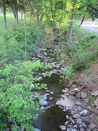
Pin Oak is an unincorporated community in Hampshire County in the U.S. state of West Virginia. Pin Oak is located along West Virginia Route 29 between Paw Paw and Forks of Cacapon. Pin Oak is roughly centered at the intersection of Pin Oak Road and Cabin Run Road with West Virginia Route 29. The old Pinoak School lies north of this intersection.

West Virginia Route 9 (WV 9) is a major east–west state highway located in the eastern extents of West Virginia's Eastern Panhandle. The western terminus of the route is at the Maryland state line on the north edge of Paw Paw, where WV 9 becomes Maryland Route 51 (MD 51) upon crossing the Potomac River. The eastern terminus is at the Virginia state line at Keyes Gap near Mannings, West Virginia, where WV 9 continues onward as Virginia State Route 9 (SR 9).

West Virginia Route 29 is a north–south state highway located in the Eastern Panhandle of West Virginia. The southern terminus of the route is at West Virginia Route 55 and West Virginia Route 259 in Baker, Hardy County. The northern terminus is at West Virginia Route 9 three miles (5 km) south of Paw Paw in Hampshire County.

The Trough is a 6-mile long wooded gorge carved by the South Branch Potomac River (SBPR) and situated in the Allegheny Mountains of Hampshire and Hardy Counties, West Virginia, USA. The area was the site of a 1756 skirmish of the French and Indian War, known as the "Battle of the Trough".
Paw Paw High School in Paw Paw, West Virginia serves grades 7 through 12 with approximately 100 students enrolled and over 20 faculty members. It is one of the two high schools in Morgan County along with Berkeley Springs High School in Berkeley Springs.

The Western Maryland Rail Trail (WMRT) is a 28-mile (45 km) shared-use rail trail in the U.S. state of Maryland that follows the former right-of-way of the Western Maryland Railway (WM) between Fort Frederick State Park and Little Orleans via Hancock, paralleling the C&O Canal and Potomac River. The asphalt-paved trail is suitable for walking, jogging, biking, rollerblading, country skiing, and snowshoeing.
Big Run is a 4.4-mile-long (7.1 km) tributary stream of the South Branch Potomac River, belonging to the Potomac River and Chesapeake Bay watersheds. Big Run flows through the city of Romney and the campus of the West Virginia Schools for the Deaf and Blind in Hampshire County, West Virginia. The stream is known by local residents as Town Run and Town Creek.
Bearwallow Creek is a 4.3-mile-long (6.9 km) tributary stream of Tearcoat Creek, itself a tributary of the North River, making it a part of the Potomac River and Chesapeake Bay watersheds. Bearwallow Creek is located in Hampshire County, West Virginia. It rises on Chestnut Oak Ridge, from which it flows southwest along the ridge's eastern flanks and then begins its course southeast along Bear Wallow Hollow Road and U.S. Route 50 until its confluence with Tearcoat Creek at Pleasant Dale.
Trout Run is an 18.5-mile-long (29.8 km) tributary of the Cacapon River, belonging to the Potomac River and Chesapeake Bay watersheds. The stream is located in Hardy County in West Virginia's Eastern Panhandle. Trout Run rises between Devils Hole Mountain and Great North Mountain near the Virginia state line in the George Washington National Forest. The stream empties into the Cacapon River at Wardensville.

Spring Gap is an unincorporated community and census-designated place (CDP) in Allegany County, Maryland, United States. As of the 2010 census it had a population of 55.
The Oak Mounds is a large prehistoric earthwork mound, and a smaller mound to the west. They are located outside Clarksburg, in Harrison County, West Virginia. These mounds have never been totally excavated but they were probably built between 1 and 1000 CE by the Hopewell culture mound builders, prehistoric indigenous peoples of eastern North America. The larger mound is about 12 feet high and 60 feet in diameter. A number of burials of important persons of the culture probably occurred in these mounds.

Culberson Woods State Nature Preserve is located in Clinton County, Ohio, United States. It protects one of the largest remnants of the white swamp forest which once covered the uplands of the Till Plans of Ohio and Indiana. This type of swamp has poorly drained, white clay soil and is wet in the winter but dry in the summer.
Pin Oak Community is an unincorporated community in Warren County, in the U.S. state of Missouri.


