
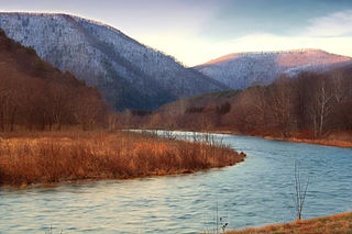
The West Branch Susquehanna River is one of the two principal branches, along with the North Branch, of the Susquehanna River in the northeastern United States. The North Branch, which rises in upstate New York, is generally regarded as the extension of the main branch, with the shorter West Branch being its principal tributary. The West Branch, which is 243 miles (391 km) long, is entirely within the state of Pennsylvania, draining a large mountainous area within the Allegheny Plateau in the western part of the state. Along most of its course it meanders along mountain ridges and through water gaps, forming a large zigzag arc through central Pennsylvania around the north end of the Allegheny Ridge. In colonial times the river provided an important water route to the Ohio River valley. In the 18th century, its lower valley became a significant industrial heartland of Pennsylvania. In the 20th century, the upper reaches of the West Branch turned a yellow/orange color due to sulfurous drainage from nearby and abandoned deep bituminous coal mines.

The Wyalusing Path or trail was a historical trace that ran from what is now Wyalusing to the Native American village of Canaserage in Pennsylvania in the United States. Wyalusing is on the east bank of the North Branch of the Susquehanna River in Bradford County and Muncy is on the east bank of the West Branch Susquehanna River in Lycoming County, so the path provided a short cut between the two main branches of the Susquehanna River. The alternative and much longer route was to follow the North Branch south from Wyalusing to the confluence with the West Branch at the Native village of Shamokin, then north up the West Branch to Muncy.

The Line of Property is the name commonly given to the line dividing Indian from British Colonial lands established in the 1768 Treaty of Fort Stanwix between the British officials and the Indian tribes. In western Pennsylvania it is referred to as the Purchase line.

Larrys Creek is a 22.9-mile-long (36.9 km) tributary of the West Branch Susquehanna River in Lycoming County in the U.S. state of Pennsylvania. A part of the Chesapeake Bay drainage basin, its watershed drains 89.1 square miles (231 km2) in six townships and a borough. The creek flows south from the dissected Allegheny Plateau to the Ridge-and-valley Appalachians through sandstone, limestone, and shale from the Devonian, Mississippian, and Pennsylvanian periods.
Pine Creek is a tributary of the West Branch Susquehanna River in Potter, Tioga, Lycoming, and Clinton counties in Pennsylvania in the United States. The creek is 87.2 miles (140.3 km) long. Within Tioga County, 23.25 miles (37.42 km) of Pine Creek are designated as a Pennsylvania Scenic River.

Anderson Creek is a 23.6-mile-long (38.0 km) tributary of the West Branch Susquehanna River in Clearfield County, Pennsylvania, in the United States.

The Great Island Path was a major Native American trail in the U.S. State of Pennsylvania that ran from the village of Shamokin along the right bank of the West Branch Susquehanna River north and then west to the Great Island.
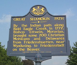
The Great Shamokin Path was a major Native American trail in the U.S. State of Pennsylvania that ran from the native village of Shamokin along the left bank of the West Branch Susquehanna River north and then west to the Great Island. There it left the river and continued further west to Chinklacamoose and finally Kittanning on the Allegheny River.

Culbertson's Path was a Native American trail in north central Pennsylvania in the United States, which connected the Great Island Path with the Sheshequin Path. The eastern / southern end of the path was on the West Branch Susquehanna River at what is now the unincorporated village of Allenwood in Gregg Township in Union County. The northern / western end was in Old Lycoming Township just north of what is now the city of Williamsport in Lycoming County.

Little Pine State Park is a Pennsylvania state park on 2,158 acres (873 ha) in Cummings Township, Lycoming County, Pennsylvania in the United States. Little Pine State park is along 4.2 miles (6.8 km) of Little Pine Creek, a tributary of Pine Creek, in the midst of the Tiadaghton State Forest. A dam on the creek has created a lake covering 94 acres (38 ha) for fishing, boating, and swimming. The park is on Pennsylvania Route 4001, 4 miles (6.4 km) northeast of the unincorporated village of Waterville or 8 miles (13 km) southwest of the village of English Center. The nearest borough is Jersey Shore, Pennsylvania, about 15 miles (24 km) south at the mouth of Pine Creek on the West Branch Susquehanna River.

Upper Pine Bottom State Park is a 5-acre (2.0 ha) Pennsylvania state park in Lycoming County, Pennsylvania in the United States. The park is in Cummings Township on Pennsylvania Route 44 and is surrounded by the Tiadaghton State Forest. It is on Upper Pine Bottom Run, which gave the park its name and is a tributary of Pine Creek. Upper Pine Bottom State Park is in the Pine Creek Gorge, where the streams have cut through five major rock formations from the Devonian and Carboniferous periods.
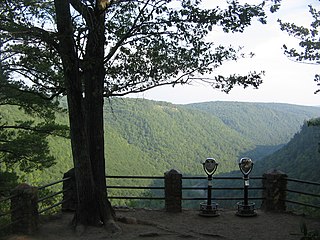
Colton Point State Park is a 368-acre (149 ha) Pennsylvania state park in Tioga County, Pennsylvania, in the United States. It is on the west side of the Pine Creek Gorge, also known as the Grand Canyon of Pennsylvania, which is 800 feet (240 m) deep and nearly 4,000 feet (1,200 m) across at this location. The park extends from the creek in the bottom of the gorge up to the rim and across part of the plateau to the west. Colton Point State Park is known for its views of the Pine Creek Gorge, and offers opportunities for picnicking, hiking, fishing and hunting, whitewater boating, and camping. Colton Point is surrounded by Tioga State Forest and its sister park, Leonard Harrison State Park, on the east rim. The park is on a state forest road in Shippen Township 5 miles (8 km) south of U.S. Route 6.

Leonard Harrison State Park is a 585-acre (237 ha) Pennsylvania state park in Tioga County, Pennsylvania, in the United States. It is on the east rim of the Pine Creek Gorge, also known as the Grand Canyon of Pennsylvania, which is 800 feet (240 m) deep and nearly 4,000 feet (1,200 m) across here. It also serves as headquarters for the adjoining Colton Point State Park, its sister park on the west rim of the gorge. Leonard Harrison State Park is known for its views of the Pine Creek Gorge, and offers hiking, fishing and hunting, whitewater boating, and camping. The park is in Shippen and Delmar Townships, 10 miles (16 km) west of Wellsboro at the western terminus of Pennsylvania Route 660.
The Jersey Shore, Pine Creek and Buffalo Railway was a railroad built in the early 1880s to give the New York Central and Hudson River Railroad access to the coal regions around Clearfield, Pennsylvania, United States. It was originally planned as part of a connecting line between the East Coast of the United States and Buffalo, New York.

The Great Indian Warpath (GIW)—also known as the Great Indian War and Trading Path, or the Seneca Trail—was that part of the network of trails in eastern North America developed and used by Native Americans which ran through the Great Appalachian Valley. The system of footpaths extended from what is now upper New York to deep within Alabama. Various Indians traded and made war along the trails, including the Catawba, numerous Algonquian tribes, the Cherokee, and the Iroquois Confederacy. The British traders' name for the route was derived from combining its name among the northeastern Algonquian tribes, Mishimayagat or "Great Trail", with that of the Shawnee and Delaware, Athawominee or "Path where they go armed".

The West Branch Susquehanna Valley of central Pennsylvania, United States, in the Ridge-and-valley Appalachians, is the low-lying area draining into the West Branch Susquehanna River southeast of the Allegheny Front, northeast of the Bald Eagle Valley, southwest of the Wyoming Valley and north of the water gap formed between Shamokin Mountain and Montour Ridge.

The Sheshequin Path was a major Native American trail in the U.S. State of Pennsylvania that ran between two Native American villages: "French Margaret's Town" on the West Branch Susquehanna River and "Sheshequin" on the North Branch of the Susquehanna River. The path ran north and east along Lycoming Creek in Lycoming County and followed much of Towanda Creek in Bradford County. It was a shortcut between the two main branches of the Susquehanna River and was used by early settlers as well as Native Americans.

The Pine Creek Rail Trail is a rail trail in the Appalachian Mountains of north-central Pennsylvania.

The Bald Eagle Creek Path was a major Native American trail in the U.S. State of Pennsylvania that ran from the Great Island on the West Branch Susquehanna River southwest to what is now the village of Frankstown on the Frankstown Branch Juniata River. The path ran from Clinton County southwest through Centre County and a small part of Blair County to its southern end in Blair County. It was part of a "Warriors Path", an important connector between paths leading to New York and the Six Nations of the Iroquois and the Ohio River country in the north and west, and paths leading to what are now Maryland, Virginia, and the Carolinas in the south.

Pine Creek Gorge, sometimes called The Grand Canyon of Pennsylvania, is a 47-mile (76 km) gorge carved into the Allegheny Plateau by Pine Creek in north-central Pennsylvania.
