
Lake Michigan is one of the five Great Lakes of North America. It is the second-largest of the Great Lakes by volume and the third-largest by surface area, after Lake Superior and Lake Huron. To the east, its basin is conjoined with that of Lake Huron through the 3+1⁄2 miles wide, 295 feet deep, Straits of Mackinac, giving it the same surface elevation as its easterly counterpart; the two are technically a single lake.
The Lower Peninsula of Michigan – also known as Lower Michigan – is the larger, southern and less elevated of the two major landmasses that make up the U.S. state of Michigan; the other being the Upper Peninsula, which is separated by the Straits of Mackinac. It is surrounded by water on all sides except its southern border, which it shares with Indiana and Ohio. Although the Upper Peninsula is commonly referred to as "the U.P.", it is uncommon for the Lower Peninsula to be called "the L.P."

Sanibel is an island and city in Lee County, Florida, United States. The population was 6,382 at the 2020 census. It is part of the Cape Coral-Fort Myers, Florida Metropolitan Statistical Area. The island, also known as Sanibel Island, constitutes the entire city. It is a barrier island—a collection of sand on the leeward side of the more solid coral-rock of Pine Island.

Drummond Township, which comprises Drummond Island, is a civil township of Chippewa County in the U.S. state of Michigan. The population was 973 at the 2020 census.

Hiawatha National Forest is a 894,836-acre (362,127 ha) National Forest in the Upper Peninsula of the state of Michigan in the United States. Commercial logging is conducted in some areas. The United States Forest Service administers this National Forest; it is physically divided into two subunits, commonly called the Eastside 46°14′N84°50′W and Westside 46°08′N86°40′W.
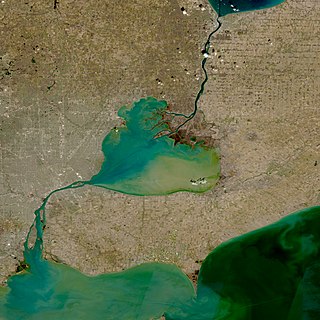
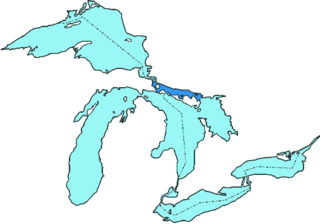
The St. Clair River is a 40.5-mile-long (65.2 km) river in central North America which flows from Lake Huron into Lake St. Clair, forming part of the international boundary between Canada and the United States and between the Canadian province of Ontario and the U.S. state of Michigan. The river is a significant component in the Great Lakes Waterway, whose shipping channels permit cargo vessels to travel between the upper and lower Great Lakes.

The Bruce Peninsula is a peninsula in Ontario, Canada, that divides Georgian Bay of Lake Huron from the lake's main basin. The peninsula extends roughly northwestwards from the rest of Southwestern Ontario, pointing towards Manitoulin Island, with which it forms the widest strait joining Georgian Bay to the rest of Lake Huron. The Bruce Peninsula contains part of the geological formation known as the Niagara Escarpment.
The Thumb is a region and a peninsula of the U.S. state of Michigan, so named because the Lower Peninsula is shaped like a mitten. The Thumb area is generally considered to be in the Central Michigan region, east of the Tri-Cities and north of Metro Detroit. The region is also branded as the Blue Water Area.

Northern Michigan, also known as Northern Lower Michigan, is a region of the U.S. state of Michigan. A popular tourist destination, it is home to several small- to medium-sized cities, extensive state and national forests, lakes and rivers, and a large portion of Great Lakes shoreline. The region has a significant seasonal population much like other regions that depend on tourism as their main industry. Northern Lower Michigan is distinct from the more northerly Upper Peninsula and Isle Royale, which are also located in "northern" Michigan. In the northernmost 21 counties in the Lower Peninsula of Michigan, the total population of the region is 506,658 people.
St. Joseph Island is in the northwestern part of Lake Huron. It is part of the Canadian province of Ontario. At 365 km2 (141 sq mi) in area, it is the sixth largest lake island in the world; the second largest island on Lake Huron, following Manitoulin Island; and the third largest of all the islands on the Great Lakes, trailing Manitoulin and Lake Superior's Isle Royale.

The Huron Islands are a group of eight small, rocky islands in Lake Superior, located about three miles (4.8 km) off the mouth of the Huron River in northwestern Marquette County, Michigan, United States. Together they comprise the Huron National Wildlife Refuge, which was established by President Theodore Roosevelt in 1905. The refuge is also known as the Huron Islands Wilderness and is a unit of the Seney National Wildlife Refuge. The underwater area around the islands is part of the Huron Islands unit of the Marquette Underwater Preserve and several shipwrecks can be visited by divers.
Gull Island is the name of a dozen small islands in the U.S. state of Michigan.

Pine River may refer to any of the following rivers in the U.S. state of Michigan:
The North Channel is the body of water along the north shore of Lake Huron, in the Canadian province of Ontario. It stretches approximately 160 nautical miles (300 km) and is bordered on the east by Georgian Bay, on the west by the St. Marys River, to the north by the eastern Algoma District and part of the Sudbury District, and to the south by the islands of Manitoulin, Cockburn, Drummond and St. Joseph. At its widest point it is over 30 km wide.

The Imperial Towers of Ontario were six of the earliest lighthouses built on Lake Huron and Georgian Bay, all constructed primarily of stone, by the Province of Canada. The origin of the designation Imperial is not certain, but some historians speculate that because the towers were public construction built under the colonial administration while Canada was a self-governing colony of Britain, the name would assure at least some funding from the British Empire's Board of Trade.
Point Clark is a lakefront cottage community on Lake Huron, in the municipality of Huron-Kinloss, Ontario, Canada. It is approximately 15 kilometres south of Kincardine and 40 kilometres north of Goderich. Main streets include Huron Road and Lake Range Road. Point Clark is served by Highway 21 (Ontario). It is a cottage town, and has a rare Imperial Tower style lighthouse. There is a sandy beach and a small harbour with a boat ramp. There are two streams or rivers that run into Lake Huron around Point Clark: Clark Creek and Pine River. There is a separate harbour in the mouth of the Pine River. Amberley is just outside and to the south of Point Clark and Lucknow is to the south-east of Point Clark.

Fairview is an unincorporated community in Oscoda County in the U.S. state of Michigan. It is located within Comins Township at the intersection of highways M-33 and M-72 at 44°43′30″N84°03′04″W.
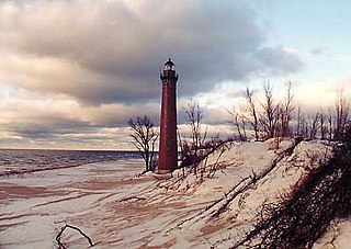
Pine River is a river in the Upper Peninsula of the U.S. state of Michigan. It rises in Chippewa County, flows into Mackinac County, and discharges into St. Martin Bay in the northwestern corner of Lake Huron.