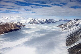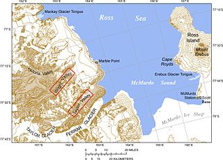
Ferrar Glacier is a glacier in Antarctica. It is about 35 nautical miles long, flowing from the plateau of Victoria Land west of the Royal Society Range to New Harbour in McMurdo Sound. The glacier makes a right (east) turn northeast of Knobhead, where it where it is apposed, i.e., joined in Siamese-twin fashion, to Taylor Glacier. From there, it continues east along the south side of Kukri Hills to New Harbor.
The Aviator Glacier is a major valley glacier in Antarctica that is over 60 nautical miles long and 5 nautical miles wide, descending generally southward from the plateau of Victoria Land along the west side of Mountaineer Range, and entering Lady Newnes Bay between Cape Sibbald and Hayes Head where it forms a floating tongue.
The Flood Range is a range of large snow-covered mountains extending in an east–west direction for about 60 nautical miles and forming a right angle with the southern end of the Ames Range in Marie Byrd Land, Antarctica.
Borchgrevink Glacier is a large glacier in the Victory Mountains, Victoria Land, Antarctica. It drains south between Malta Plateau and Daniell Peninsula, and thence projects into Glacier Strait, Ross Sea, as a floating glacier tongue.

The Prince Charles Mountains are a major group of mountains in Mac. Robertson Land in Antarctica, including the Athos Range, the Porthos Range, and the Aramis Range. The highest peak is Mount Menzies, with a height of 3,228 m (10,591 ft). Other prominent peaks are Mount Izabelle and Mount Stinear. These mountains, together with other scattered peaks, form an arc about 420 km (260 mi) long, extending from the vicinity of Mount Starlight in the north to Goodspeed Nunataks in the south.
The Northumberland Islands are a scattered island chain off the eastern coast of Queensland, Australia.

The Outback Nunataks are a series of bare rock nunataks and mountains which are distributed over an area about 40 nautical miles long by 20 nautical miles wide. The group lies south of Emlen Peaks of the Usarp Mountains and west of Monument Nunataks and upper Rennick Glacier, adjacent to the featureless interior plateau.
Athos Range is the northernmost range in the Prince Charles Mountains of Mac. Robertson Land, Antarctica. The range consists of many individual mountains and nunataks that trend east–west for 40 miles (64 km) along the north side of Scylla Glacier.

The David Glacier is a glacier over 60 nautical miles long, flowing east from the polar plateau through the Prince Albert Mountains to the coast of Victoria Land, Antarctica. It enters Ross Sea between Cape Philippi and Cape Reynolds to form the floating Drygalski Ice Tongue. It is the most imposing outlet glacier in Victoria Land. It is fed by two main flows which drain an area larger than 200,000 square kilometres, with an estimated ice discharge rate of 7.8 +/- 0.7 km3/year. The David Glacier was discovered by Ernest Shackleton's "Northern Party," in November 1908, under the leadership of Prof. T.W. Edgeworth David, of Sydney University, for whom the feature was named.
Chimoré is a location in the Carrasco Province, Cochabamba Department, Bolivia. It is the seat of the Chimoré Municipality.
Tanambao Daoud or Tanambao is a rural municipality in northern Madagascar. It belongs to the district of Sambava, which is a part of Sava Region. The population of the commune was estimated to be approximately 10,000 in 2001 commune census.
Francisco Santos, Piauí is a municipality in the state of Piauí in the Northeast region of Brazil.
Watson Escarpment is a major escarpment in the Queen Maud Mountains, trending northward along the east margin of Scott Glacier, then eastward to Reedy Glacier where it turns southward along the glacier's west side. Somewhat arcuate, the escarpment is nearly 100 nautical miles long, rises 3,550 metres (11,650 ft) above sea level, and 1,000 to 1,500 metres above the adjacent terrain.
The Mesa Range is a range of flat-topped mesas comprising the Sheehan, Pain, Tobin and Gair Mesas, situated at the head of the Rennick Glacier in Victoria Land, Antarctica. It was given this descriptive name by the northern party of the New Zealand Geological Survey Antarctic Expedition (NZGSAE) of 1962–63.
The Hutton Mountains are a group of mountains in southeast Palmer Land, Antarctica, bounded on the southwest by Johnston Glacier, on the northwest by Squires Glacier, on the north by Swann Glacier, and on the east by Keller Inlet.

Mackay Glacier is a large glacier in Victoria Land, descending eastward from the Antarctic Plateau, between the Convoy Range and Clare Range, into the southern part of Granite Harbour. It was discovered by the South magnetic pole party of the British Antarctic Expedition, 1907–09, and named for Alistair Mackay, a member of the party. The glacier's tongue is called Mackay Glacier Tongue. First mapped by the British Antarctic Expedition, 1910–13 and named for Alistair F. Mackay, a member of the party. Its mouth is south of the Evans Piedmont Glacier and the Mawson Glacier. It is north of the Wilson Piedmont Glacier and the Ferrar Glacier.

Rogers Glacier is a broad glacier entering the eastern side of Amery Ice Shelf close northward of McKaskle Hills. Delineated in 1952 by John H. Roscoe from air photos taken by U.S. Navy Operation Highjump (1946–47), and named by him for Lieutenant Commander William J. Rogers, Jr., U.S. Navy, plane commander of one of the three air crews during Operation Highjump which took air photos of the coastal areas between 14 and 164 East longitude.
Rouchel Brook, a perennial stream of the Hunter River catchment, is located in the Hunter region of New South Wales, Australia.

Cerro Porquesa (Aymara) is an approximately 4,600 metres (15,100 ft) high rhyodacite lava dome in the Andes. It has a 1.5 by 3 kilometres oval outline, and is 800 metres (2,600 ft) high. The lava dome is accompanied by block-and-ash flows and lava flows and the presence of two volcanic cones has been reported. The lava dome is of Pliocene/Pleistocene age with little glacial features on the younger domes indicating young ages. The Quebrada de Piga, which flows to Salar de Huasco, originates at Cerro Porquesa.
![]() This article incorporates public domain material from "Pionerskiy Dome". Geographic Names Information System . United States Geological Survey.
This article incorporates public domain material from "Pionerskiy Dome". Geographic Names Information System . United States Geological Survey. 


