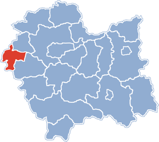
Gmina Polanka Wielka is a rural gmina in Oświęcim County, Lesser Poland Voivodeship, in southern Poland. Its seat is the village of Polanka Wielka, which lies approximately 10 kilometres (6 mi) south-east of Oświęcim and 46 km (29 mi) west of the regional capital Kraków.

Wojciechów is a village in the administrative district of Gmina Przedbórz, within Radomsko County, Łódź Voivodeship, in central Poland. It lies approximately 8 kilometres (5 mi) east of Przedbórz, 37 km (23 mi) east of Radomsko, and 88 km (55 mi) south-east of the regional capital Łódź.
Przecieszyn is a village in the administrative district of Gmina Brzeszcze, within Oświęcim County, Lesser Poland Voivodeship, in southern Poland. It lies approximately 5 kilometres (3 mi) south-east of Brzeszcze, 10 km (6 mi) south of Oświęcim, and 56 km (35 mi) west of the regional capital Kraków.
Skidziń is a village in the administrative district of Gmina Brzeszcze, within Oświęcim County, Lesser Poland Voivodeship, in southern Poland. It lies approximately 5 kilometres (3 mi) south-east of Brzeszcze, 8 km (5 mi) south of Oświęcim, and 54 km (34 mi) west of the regional capital Kraków.
Bielany is a village in the administrative district of Gmina Kęty, within Oświęcim County, Lesser Poland Voivodeship, in southern Poland. It lies approximately 5 kilometres (3 mi) north of Kęty, 13 km (8 mi) south of Oświęcim, and 55 km (34 mi) west of the regional capital Kraków.
Bulowice is a village in the administrative district of Gmina Kęty, within Oświęcim County, Lesser Poland Voivodeship, in southern Poland. It lies approximately 8 kilometres (5 mi) south of Kęty, 25 km (16 mi) south of Oświęcim, and 56 km (35 mi) south-west of the regional capital Kraków.
Łęki is a village in the administrative district of Gmina Kęty, within Oświęcim County, Lesser Poland Voivodeship, in southern Poland. It lies approximately 6 kilometres (4 mi) north of Kęty, 12 km (7 mi) south of Oświęcim, and 54 km (34 mi) west of the regional capital Kraków.

Nowa Wieś is a village in the administrative district of Gmina Kęty, within Oświęcim County, Lesser Poland Voivodeship, in southern Poland. It lies approximately 1 kilometre (1 mi) north of Kęty, 16 km (10 mi) south of Oświęcim, and 55 km (34 mi) west of the regional capital Kraków.
Witkowice is a village in the administrative district of Gmina Kęty, within Oświęcim County, Lesser Poland Voivodeship, in southern Poland. It lies approximately 5 kilometres (3 mi) east of Kęty, 16 km (10 mi) south of Oświęcim, and 50 km (31 mi) west of the regional capital Kraków.
Łazy is a village in the administrative district of Gmina Oświęcim, within Oświęcim County, Lesser Poland Voivodeship, in southern Poland. It lies approximately 8 kilometres (5 mi) south of Oświęcim and 49 km (30 mi) west of the regional capital Kraków.
Przeciszów is a village in Oświęcim County, Lesser Poland Voivodeship, in southern Poland. It is the seat of the gmina called Gmina Przeciszów. It lies approximately 12 kilometres (7 mi) east of Oświęcim and 40 km (25 mi) west of the regional capital Kraków.

Graboszyce is a village in the administrative district of Gmina Zator, within Oświęcim County, Lesser Poland Voivodeship, in southern Poland. It lies approximately 6 kilometres (4 mi) south of Zator, 20 km (12 mi) south-east of Oświęcim, and 38 km (24 mi) west of the regional capital Kraków.
Grodzisko is a village in the administrative district of Gmina Zator, within Oświęcim County, Lesser Poland Voivodeship, in southern Poland. It lies approximately 5 kilometres (3 mi) south of Zator, 19 km (12 mi) south-east of Oświęcim, and 36 km (22 mi) west of the regional capital Kraków.
Laskowa is a village in the administrative district of Gmina Zator, within Oświęcim County, Lesser Poland Voivodeship, in southern Poland. It lies approximately 3 kilometres (2 mi) south-east of Zator, 19 km (12 mi) south-east of Oświęcim, and 35 km (22 mi) west of the regional capital Kraków.
Łowiczki is a village in the administrative district of Gmina Zator, within Oświęcim County, Lesser Poland Voivodeship, in southern Poland. It lies approximately 4 kilometres (2 mi) south-west of Zator, 16 km (10 mi) south-east of Oświęcim, and 39 km (24 mi) west of the regional capital Kraków.
Rudze is a village in the administrative district of Gmina Zator, within Oświęcim County, Lesser Poland Voivodeship, in southern Poland. It lies approximately 2 kilometres (1 mi) south-east of Zator, 18 km (11 mi) south-east of Oświęcim, and 36 km (22 mi) west of the regional capital Kraków.
Trzebieńczyce is a village in the administrative district of Gmina Zator, within Oświęcim County, Lesser Poland Voivodeship, in southern Poland. It lies approximately 3 kilometres (2 mi) south-east of Zator, 19 km (12 mi) south-east of Oświęcim, and 35 km (22 mi) west of the regional capital Kraków.
Nowa Wieś is a village in the administrative district of Gmina Stopnica, within Busko County, Świętokrzyskie Voivodeship, in south-central Poland. It lies approximately 3 kilometres (2 mi) east of Stopnica, 19 km (12 mi) east of Busko-Zdrój, and 56 km (35 mi) south-east of the regional capital Kielce.

Pisarzowice is a village in the administrative district of Gmina Wilamowice, within Bielsko County, Silesian Voivodeship, in southern Poland. It lies approximately 4 kilometres (2 mi) south of Wilamowice, 8 km (5 mi) north-east of Bielsko-Biała, and 42 km (26 mi) south of the regional capital Katowice. The village has a population of 4,673.