Osiek is a village in Oświęcim County, Lesser Poland Voivodeship, in southern Poland. It is the seat of the gmina called Gmina Osiek. It lies approximately 12 kilometres (7 mi) south of Oświęcim and 50 km (31 mi) west of the regional capital Kraków.
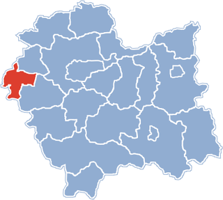
Gmina Oświęcim is a rural gmina in Oświęcim County, Lesser Poland Voivodeship, in southern Poland. Its seat is the town of Oświęcim, although the town is not part of the territory of the gmina.
Gmina Polanka Wielka is a rural gmina in Oświęcim County, Lesser Poland Voivodeship, in southern Poland. Its seat is the village of Polanka Wielka, which lies approximately 10 kilometres (6 mi) south-east of Oświęcim and 46 km (29 mi) west of the regional capital Kraków.
Gmina Przeciszów is a rural gmina in Oświęcim County, Lesser Poland Voivodeship, in southern Poland. Its seat is the village of Przeciszów, which lies approximately 12 kilometres (7 mi) east of Oświęcim and 40 km (25 mi) west of the regional capital Kraków.

Śladków Podleśny is a village in the administrative district of Gmina Piątek, within Łęczyca County, Łódź Voivodeship, in central Poland. It lies approximately 9 kilometres (6 mi) south-west of Piątek, 13.9 km (9 mi) east of Łęczyca, and 27 km (17 mi) north of the regional capital Łódź.
Bulowice is a village in the administrative district of Gmina Kęty, within Oświęcim County, Lesser Poland Voivodeship, in southern Poland. It lies approximately 8 kilometres (5 mi) south of Kęty, 25 km (16 mi) south of Oświęcim, and 56 km (35 mi) south-west of the regional capital Kraków.
Witkowice is a village in the administrative district of Gmina Kęty, within Oświęcim County, Lesser Poland Voivodeship, in southern Poland. It lies approximately 5 kilometres (3 mi) east of Kęty, 16 km (10 mi) south of Oświęcim, and 50 km (31 mi) west of the regional capital Kraków.
Broszkowice is a village in the administrative district of Gmina Oświęcim, within Oświęcim County, Lesser Poland Voivodeship, in southern Poland. It lies approximately 1 kilometre (1 mi) north of Oświęcim and 51 km (32 mi) west of the regional capital Kraków.
Harmęże is a village in the administrative district of Gmina Oświęcim, within Oświęcim County, Lesser Poland Voivodeship, in southern Poland. It lies approximately 8 kilometres (5 mi) south-west of Oświęcim and 57 km (35 mi) west of the regional capital Kraków. The village has a population of 613.
Pławy is a village in the administrative district of Gmina Oświęcim, within Oświęcim County, Lesser Poland Voivodeship, in southern Poland. It lies approximately 7 kilometres (4 mi) west of Oświęcim and 57 km (35 mi) west of the regional capital Kraków.

Poręba Wielka is a village in the administrative district of Gmina Oświęcim, within Oświęcim County, Lesser Poland Voivodeship, in southern Poland. It lies approximately 7 kilometres (4 mi) south-east of Oświęcim and 48 km (30 mi) west of the regional capital Kraków.

Rajsko is a village in the administrative district of Gmina Oświęcim, within Oświęcim County, Lesser Poland Voivodeship, in southern Poland. It lies approximately 7 kilometres (4 mi) south-west of Oświęcim and 55 km (34 mi) west of the regional capital Kraków.
Stawy Monowskie is a village in the administrative district of Gmina Oświęcim, within Oświęcim County, Lesser Poland Voivodeship, in southern Poland. It lies approximately 9 kilometres (6 mi) south-east of Oświęcim and 44 km (27 mi) west of the regional capital Kraków.
Włosienica is a village in the administrative district of Gmina Oświęcim, within Oświęcim County, Lesser Poland Voivodeship, in southern Poland. It lies approximately 8 kilometres (5 mi) south-east of Oświęcim and 45 km (28 mi) west of the regional capital Kraków.
Zaborze is a village in the administrative district of Gmina Oświęcim, within Oświęcim County, Lesser Poland Voivodeship, in southern Poland. It lies approximately 5 kilometres (3 mi) south of Oświęcim and 51 km (32 mi) west of the regional capital Kraków.
Piotrowice is a village in the administrative district of Gmina Przeciszów, within Oświęcim County, Lesser Poland Voivodeship, in southern Poland. It lies approximately 5 kilometres (3 mi) south of Przeciszów, 13 km (8 mi) south-east of Oświęcim, and 42 km (26 mi) west of the regional capital Kraków.
Palczowice is a village in the administrative district of Gmina Zator, within Oświęcim County, Lesser Poland Voivodeship, in southern Poland. It lies approximately 17 km (11 mi) east of Oświęcim and 36 km (22 mi) west of the regional capital Kraków.
Podolsze is a village in the administrative district of Gmina Zator, within Oświęcim County, Lesser Poland Voivodeship, in southern Poland. It lies approximately 3 kilometres (2 mi) north of Zator, 15 km (9 mi) east of Oświęcim, and 37 km (23 mi) west of the regional capital Kraków.
Smolice is a village in the administrative district of Gmina Zator, within Oświęcim County, Lesser Poland Voivodeship, in southern Poland. It lies approximately 5 kilometres (3 mi) north-east of Zator, 17 km (11 mi) east of Oświęcim, and 34 km (21 mi) west of the regional capital Kraków.
Waleriany is a village in the administrative district of Gmina Puszcza Mariańska, within Żyrardów County, Masovian Voivodeship, in east-central Poland. It lies approximately 5 kilometres (3 mi) north-east of Puszcza Mariańska, 6 km (4 mi) south-west of Żyrardów, and 48 km (30 mi) south-west of Warsaw.