Ord. of the Bureau des Finances on 16 January 1789
Denomination
Arr. on 30 December 1864
Nightfall in the Place de Clichy
The Place de Clichy, also known as "Place Clichy", is situated in the northwestern quadrant of Paris. It is formed by the intersection of the Boulevard de Clichy, the Avenue Clichy, the Rue Clichy, the Boulevard des Batignolles, and the Rue d'Amsterdam.
It lies at the former site of the barrière de Clichy, an ancient portal in the Wall of the Farmers-General, leading to the village of Clichy, outside the wall.
Description
The Place de Clichy is one of the few places in Paris where four arrondissements (the 8th, 9th, 17th, and 18th) meet at a single point. (The others are the Pont Saint-Michel, where the 1st, 4th, 5th, and 6th meet, and the Belleville roundabout, where the 10th, 11th, 19th and 20th come together.)
The Place de Clichy is also unusual in that it has been untouched by urban planners. This explains the heterogeneous façades[citation needed] of the buildings in the area. The Place de Clichy has the character of a substantial crossroads, rather than that of a real place (public square).
Surrounding the Place de Clichy is a lively array of shops, restaurants, and businesses, including a popular cinema. It is a hive of activity, both day and night.
History
In March 1814, at the close of the First French Empire, 800,000 soldiers of various foreign armies marched on Paris. After breaking through the barriers at Belleville and Pantin, they took the hill of Montmartre. Paris was protected in the north from Clichy to Neuilly, by 70,000 men of the garde nationale. In the face of the advancing enemy, the Maréchal de Moncey defended the barrière de Clichy. Moncey amassed 15,000 volunteers, tirailleurs – students from the École polytechnique and the École vétérinaire – and, despite their inexperience, valiantly resisted the Russian contingent until an armistice was declared on 30 March 1814.
Monument
A six-metre-tall bronze statue, executed by Amédée Donatien Doublemard and dedicated to de Moncey, stands on an ornate pedestal eight metres tall.
Metro station
Served by the Place de Clichy Métro station, the area is accessible by lines 2 and 13.
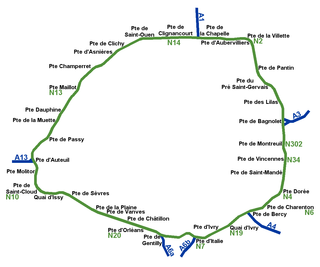
Boulevard Périphérique, sometimes called Périph', is a controlled-access dual-carriageway ring road in Paris, France. With a few exceptions, it is situated along Paris's administrative limit.
The Catacombs of Paris are underground ossuaries in Paris, France, which hold the remains of more than six million people in a small part of a tunnel network built to consolidate Paris' ancient stone quarries. Extending south from the Barrière d'Enfer former city gate, this ossuary was created as part of the effort to eliminate the city's overflowing cemeteries. Preparation work began shortly after a 1774 series of gruesome Saint Innocents-cemetery-quarter basement wall collapses added a sense of urgency to the cemetery-eliminating measure, and from 1786, nightly processions of covered wagons transferred remains from most of Paris' cemeteries to a mine shaft opened near the Rue de la Tombe-Issoire.
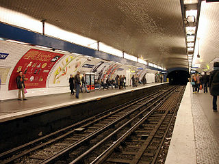
Place de Clichy is a station of the Paris Métro, serving Paris Metro Line 2 and Line 13 at the junction of the 8th and 17th arrondissement of Paris.
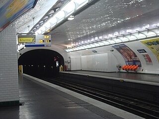
Blanche is a station on Paris Métro Line 2, on the border of the 9th and the 18th arrondissements.
Pasteur is a station on Line 6 and Line 12 of the Paris Métro in the 15th arrondissement. The platforms for both lines are situated underground, although Line 6 becomes elevated as it approaches northwest end of the station. Nearby are the Pasteur Institute and the Lycée Buffon (school).
Belleville is a neighbourhood of Paris, France, parts of which lie in four different arrondissements. The major portion of Belleville straddles the borderline between the 20th arrondissement and the 19th along its main street, the Rue de Belleville. The remainder lies in the 10th and 11th arrondissements.
Boulevard Saint-Germain is a major street in Paris on the Rive Gauche of the Seine.
Wallace Fountains are public drinking fountains roughly designed by Sir Richard Wallace and sculpted by Charles-Auguste Lebourg. They are large cast-iron sculptures scattered throughout the city of Paris, France, mainly along the most-frequented sidewalks. They are named after the Englishman Richard Wallace, who financed their construction. A great aesthetic success, they are recognized worldwide as one of the symbols of Paris. A Wallace Fountain can be seen outside the Wallace Collection in London, the gallery that houses the works of art collected by Sir Richard Wallace and the first four Marquesses of Hertford.
Paris is characterised by 19th century design and architecture, but has many areas with structures and design dating further back. These sections are often not referenced on modern-day maps of Paris, crossing current arrondissements. These quarters are best described and categorised independently of modern administrative boundaries.
The Wall of the Ferme générale was commissioned by Antoine Lavoisier and built between 1784 and 1791 by the Ferme générale, the corporation of tax farmers. It was one of the several city walls of Paris built between the early Middle Ages and the mid 19th century. It was 24 kilometers long and roughly followed the route now occupied by line 2 and line 6 of the Métro. It crossed the districts of the Place de l'Étoile, Batignolles, Pigalle, Belleville, Nation, the Place d'Italie, Denfert-Rochereau, Montparnasse and the Trocadéro.
The Place d'Italie is a public space in the 13th arrondissement of Paris. The square has an average dimension somewhat less than 200 meters in extent, and the following streets meet there:
The mines of Paris comprise a number of abandoned, subterranean mines under Paris, France, connected together by galleries. Three main networks exist; the largest, known as the grand réseau sud, lies under the 5th, 6th, 14th and 15th arrondissements, a second under the 13th arrondissement, and a third under the 16th, though other minor networks are found under the 12th, 14th and 16th for instance. The commercial product was Lutetian limestone for use as a building material, as well as gypsum for use in "plaster of Paris".
The Boulevard Auguste-Blanqui is a boulevard in the 13th arrondissement of Paris. It is one of the main arteries linking the Place d'Italie with the Place Denfert-Rochereau.
The Boulevards of the Marshals are a collection of thoroughfares that encircle the city of Paris, France, just inside its city limits. Most bear the name of a marshal of the First French Empire (1804–1814) who served under Napoleon I. The Île-de-France tramway Lines 3a and 3b today run on the Boulevards of the Marshals.
While Paris is encircled by the Boulevard Périphérique, the city gates of Paris are the access points to the city for pedestrians and other road users. As Paris has had successive ring roads through the centuries, city gates are found inside the modern-day Paris.
Porte de Clichy is a station on Line 13 and Line 14 of the Paris Métro and RER C, as well as a stop on Île-de-France tramway Line 3b. Located in the 17th arrondissement, the Métro station is situated on the northwestern branch of Line 13, under the Avenue de Clichy. It serves the Tribunal de grande instance de Paris.
The Walls of Paris refers to the city walls that surrounded Paris, France, as it grew from ancient times until the 20th century, built primarily to defend the city but also for administrative reasons. Several successive city walls were built over the centuries, either adding to existing walls or replacing demolished ones, through 1846, when construction of the Thiers wall was completed. The city walls of Paris include:
This article presents the main landmarks in the city of Paris within administrative limits, divided by its 20 arrondissements. Landmarks located in the suburbs of Paris, outside of its administrative limits, while within the metropolitan area are not included in this article.
The following outline is provided as an overview of and topical guide to Paris:
Chez le Père Lathuille is an 1879 oil-on-canvas painting by Édouard Manet, now in the Musée des Beaux-Arts Tournai. In the background is the proprietor. Manet also painted a portrait of his daughter.
This page is based on this Wikipedia article Text is available under the CC BY-SA 4.0 license; additional terms may apply. Images, videos and audio are available under their respective licenses.