The Bahamas, officially the Commonwealth of The Bahamas, is a country in North America. It is an island country within the Lucayan Archipelago of the West Indies in the Atlantic Ocean. It contains 97% of the Lucayan Archipelago's land area and 88% of its population. The archipelagic state consists of more than 3,000 islands, cays, and islets in the Atlantic Ocean, and is located north of Cuba and northwest of the island of Hispaniola and the Turks and Caicos Islands, southeast of the U.S. state of Florida, and east of the Florida Keys. The capital is Nassau on the island of New Providence. The Royal Bahamas Defence Force describes The Bahamas' territory as encompassing 470,000 km2 (180,000 sq mi) of ocean space.
The Lucayan people were the original residents of The Bahamas and the Turks and Caicos Islands before the European colonisation of the Americas. They were a branch of the Taínos who inhabited most of the Caribbean islands at the time. The Lucayans were the first Indigenous Americans encountered by Christopher Columbus. Shortly after contact, the Spanish kidnapped and enslaved Lucayans, with the displacement culminating in the complete eradication of the Lucayan people from the Bahamas by 1520.

San Salvador Island, previously Watling's Island, is an island and district of the Bahamas, famed for being the probable location of Christopher Columbus's first landing of the Americas on 12 October 1492 during his first voyage. This historical importance, the island's tropical beaches, and its proximity to the United States have made tourism central to the local economy. The island has a population of 824 (2022) and is under the administration of Gilbert C. Kemp. Its largest settlement and seat of local government is Cockburn Town.
Grand Turk is an island in the Turks and Caicos Islands, a British Overseas Territory, tropical islands in the Lucayan Archipelago of the Atlantic Ocean and northern West Indies. It is the largest island in the Turks Islands with 18 km2 (6.9 sq mi). Grand Turk contains the territory's capital, Cockburn Town, and the JAGS McCartney International Airport. The island is the administrative, historic, cultural and financial centre of the territory and has the second-largest population of the islands at approximately 4,831 people in 2012.

The Abaco Islands lie in the northern Bahamas, about 193 miles east of Miami, Florida. The main islands are Great Abaco and Little Abaco, which is just west of Great Abaco's northern tip. There are several smaller barrier cays, of which the northernmost are Walker's Cay and its sister island Grand Cay. To the south, the next inhabited islands are Spanish Cay and Green Turtle Cay, with its settlement of New Plymouth, Great Guana Cay, private Scotland Cay, Man-O-War Cay, and Elbow Cay, with its settlement of Hope Town. Southernmost are Tilloo Cay and Lubbers Quarters. Also of note off Abaco's western shore is Gorda Cay, now a Disney-owned island and cruise ship stop renamed Castaway Cay. Also in the vicinity is Moore's Island. On the Big Island of Abaco is Marsh Harbour, the Abacos' commercial hub and the Bahamas' third-largest city, plus the resort area of Treasure Cay. Both have airports. A few mainland settlements of significance are Coopers Town and Fox Town in the north and Cherokee and Sandy Point in the south. Administratively, the Abaco Islands constitute seven of the 31 Local Government Districts of the Bahamas: Grand Cay, North Abaco, Green Turtle Cay, Central Abaco, South Abaco, Moore's Island, and Hope Town.

Ragged Island is a 23 km2 (8.9 sq mi) island and district in the southern Bahamas. Ragged Island is part of the Jumentos Cays and Ragged Island Chain. The crescent-shaped chain measures over 180 km (110 mi) in length and includes cays known as Raccoon Cay, Hog Cay and Double-Breasted Cay. Island ownership is stated to have been granted to William George Lockhart some time in the 18th century. On 8 September 2017, Duncan Town took a direct hit from Hurricane Irma.

Acklins is an island and district of the Bahamas.

Rum Cay is an island and district of the Bahamas. It measures 30 square miles (78 km2) in area, it is located at Lat.: N23 42' 30" - Long.: W 74 50' 00". It has many rolling hills that rise to about 120 feet.

Guanahaní was the Taíno name of an island in the Bahamas that was the first land in the New World sighted and visited by Christopher Columbus' first voyage, on 12 October 1492. It is a bean-shaped island that Columbus called San Salvador. Guanahaní has traditionally been identified with Watlings Island, which was officially renamed San Salvador Island in 1925 as a result, but modern scholars are divided on the accuracy of this identification and several alternative candidates in and around the southern Bahamas have been proposed as well.

Elbow Cay is an five-mile-long (8.0-kilometre) cay in the Abaco Islands of the Bahamas. Originally populated by British loyalists fleeing the newly independent United States of America in 1785, it has survived on fishing, boat building, and salvage. Its main village of Hope Town surrounds a protected harbor with a noted red-and-white-striped one-hundred-and-twenty-foot-tall (37-metre) lighthouse built in 1863. On September 1, 2019, Elbow Cay took a direct hit from Category 5 Hurricane Dorian, with sustained winds of 185 mph (295 km/h). The lighthouse survived.

Samana Cay is a now uninhabited island in the Bahamas believed by some researchers to have been the location of Christopher Columbus's first landfall in the Americas on October 12, 1492.

Hutias are moderately large cavy-like rodents of the subfamily Capromyinae that inhabit the Caribbean islands. Most species are restricted to Cuba, but species are known from all of the Greater Antilles, as well as The Bahamas and (formerly) Little Swan Island off of Honduras.
Man-O-War Cay is a small island in the Abaco region of the Bahamas. It had a population of 215 at the 2010 census.

Geocapromys is a genus of rodent belonging to the hutia subfamily and are currently only found on the Bahamas and Jamaica. However, they formerly ranged throughout the Caribbean, from Cuba to the Cayman Islands to even islands off mainland Central America.
Desmarest's hutia or the Cuban hutia is a stout, furry, rat-like mammal found only on Cuba and nearby islands. Growing to about 60 cm (2 ft), it normally lives in pairs and feeds on leaves, fruit, bark and sometimes small animals. It is the largest living hutia, a group of rodents native to the Caribbean that are mostly endangered or extinct. Desmarest's hutia remains widespread throughout its range, though one subspecies native to the nearby Cayman Islands went extinct shortly after European colonization in the 1500s.

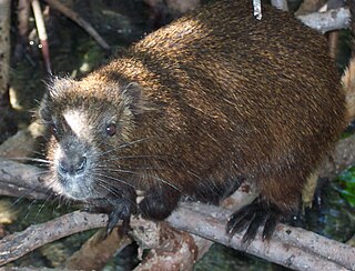
The Bahamian hutia or Ingraham's hutia is a small, furry, rat-like mammal found only in the Bahamas. About the size of a rabbit, it lives in burrows in forests or shrubland, emerging at night to feed on leaves, fruit, and other plant matter. It was believed extinct until rediscovery in 1964, and it remains the focus of conservation efforts. The Bahamian hutia is a member of the hutia subfamily (Capromyinae), a group of rodents native to the Caribbean, many of which are endangered or extinct.
The Caribbean bioregion is a biogeographic region that includes the islands of the Caribbean Sea and nearby Atlantic islands, which share a fauna, flora and mycobiota distinct from surrounding bioregions.

Long Island is an island in The Bahamas that is split by the Tropic of Cancer. It is one of the Districts of the Bahamas and is known as the most scenic island in the Bahamas. Its capital is Clarence Town. The population of Long Island is 3,094 inhabitants.

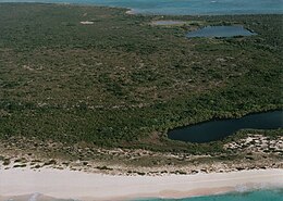
The Conception Island National Park is a protected area in the Bahamas. The island lies between Cat Island to the north and Rum Cay to the south. The vegetation consists of mangrove communities, with typical strand vegetation, and the island is visited by green turtles, sea birds and migrating birds.