The geography of Croatia is defined by its location—it is described as located at the crossroads of Central Europe and Southeast Europe, a part of the Balkans and Southern Europe. Croatia's territory covers 56,594 km2 (21,851 sq mi), making it the 127th largest country in the world. Bordered by Slovenia in the northwest, Hungary in the northeast, Bosnia and Herzegovina and Serbia in the east, Montenegro in the southeast and the Adriatic Sea in the south, it lies mostly between latitudes 42° and 47° N and longitudes 13° and 20° E. Croatia's territorial waters encompass 18,981 square kilometres (7,329 sq mi) in a 12 nautical miles wide zone, and its internal waters located within the baseline cover an additional 12,498 square kilometres (4,826 sq mi).
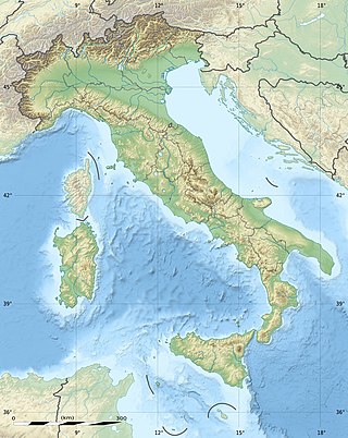
The geography of Italy includes the description of all the physical geographical elements of Italy. Italy, whose territory largely coincides with the homonymous geographical region, is located in southern Europe and comprises the long, boot-shaped Italian Peninsula crossed by the Apennines, the southern side of Alps, the large plain of the Po Valley and some islands including Sicily and Sardinia. Italy is part of the Northern Hemisphere. Two of the Pelagie Islands are located on the African continent.

The geography of Switzerland features a mountainous and landlocked country located in Western and Central Europe. Switzerland's natural landscape is marked by its numerous lakes and mountains. It is surrounded by five countries: Austria and Liechtenstein to the east, France to the west, Italy to the south and Germany to the north. Switzerland has a maximum north–south length of 220 kilometres (140 mi) and an east–west length of about 350 kilometres (220 mi).

The Alpine region of Switzerland, conventionally referred to as the Swiss Alps, represents a major natural feature of the country and is, along with the Swiss Plateau and the Swiss portion of the Jura Mountains, one of its three main physiographic regions. The Swiss Alps extend over both the Western Alps and the Eastern Alps, encompassing an area sometimes called Central Alps. While the northern ranges from the Bernese Alps to the Appenzell Alps are entirely in Switzerland, the southern ranges from the Mont Blanc massif to the Bernina massif are shared with other countries such as France, Italy, Austria and Liechtenstein.
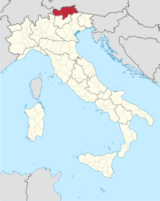
South Tyrol is an autonomous province in northern Italy. An English translation of the official German and Italian names could be the autonomous province Bolzano – South Tyrol, reflecting the multilingualism and different naming conventions in the area. Together with the autonomous province of Trento, South Tyrol forms the autonomous region of Trentino-Alto Adige/Südtirol. The province is the northernmost of Italy, the second largest with an area of 7,400 square kilometres (2,857 sq mi), and has a total population of about 534,000 inhabitants as of 2021. Its capital and largest city is Bolzano.

Trentino-Alto Adige/Südtirol is an autonomous region of Italy, located in the northern part of the country. The region has a population of 1.1 million, of whom 62% speak Italian as their mother tongue, 30% speak South Tyrolean German and several foreign languages are spoken by immigrant communities. Since the 1970s, most legislative and administrative powers have been transferred to the two self-governing provinces that make up the region: the province of Trento, commonly known as Trentino, and the province of Bolzano, commonly known as South Tyrol. In South Tyrol, German remains the sizeable majority language.

Friuli is a historical region of northeast Italy. The region is marked by its separate regional and ethnic identity predominantly tied to the Friulians, who traditionally spoke the Friulian language. It comprises the major part of the autonomous region Friuli-Venezia Giulia, i.e. the administrative provinces of Udine, Pordenone, and Gorizia, excluding Trieste.

The High Tauern are a mountain range on the main chain of the Central Eastern Alps, comprising the highest peaks east of the Brenner Pass. The crest forms the southern border of the Austrian states of Salzburg, Carinthia and East Tyrol, with a small part in the southwest belongs to the Italian province of South Tyrol. The range includes Austria's highest mountain, the Grossglockner at 3,798 metres (12,461 ft) above the Adriatic.

Ortler is, at 3,905 m (12,812 ft) above sea level, the highest mountain in the Eastern Alps outside the Bernina Range. It is the main peak of the Ortler Range. It is the highest point of the Southern Limestone Alps, of South Tyrol in Italy, of Tyrol overall, and, until 1919, of the Austrian-Hungarian empire. In German the mountain is commonly referred to as "König Ortler", like in the unofficial hymn of South Tyrol, the Bozner Bergsteigerlied.

Marmolada is a mountain in northeastern Italy and the highest mountain of the Dolomites. It lies between the borders of Trentino and Veneto. The Marmolada is an ultra-prominent peak (Ultra), known as the "Queen of the Dolomites".
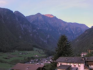
Martell is a valley and comune (municipality) in South Tyrol in northern Italy. It is located in the Martell Valley of the 28.5-kilometre (17.7 mi) long river Plima, about 45 kilometres (28 mi) west of Bolzano. The commune reaches from an elevation of 957 metres (3,140 ft) up to the 3,757 metres (12,326 ft) of the Zufallspitze which towers over the southeastern end of the valley. It is the only comune in Italy without any native speakers of Italian.

Peio is a comune (municipality) in Trentino in the northern Italian region Trentino-Alto Adige/Südtirol, located about 80 kilometres (50 mi) northwest of Trento. As of 31 December 2004, it had a population of 1,892 and an area of 162.3 square kilometres (62.7 sq mi).

Chiavenna or Claven; archaic German: Cläven or Kleven) is a comune (municipality) in the Province of Sondrio in the northern Italian region of Lombardy. It is the centre of the Alpine Valchiavenna region. The historic town is a member of the Cittaslow movement.
Stelvio National Park is a national park in northeast Italy, established in 1935.

Punta San Matteo is a secondary peak of Ortler-Vioz in the Ortler Alps, at the border between the Province of Sondrio and Trentino in northern Italy.

The Jôf di Montasio is a mountain located in the Province of Udine, in the Friuli Venezia Giulia region of northeastern Italy.

The Brenner Railway is a major line connecting the Austrian and Italian railways from Innsbruck to Verona, climbing up the Wipptal, passing over the Brenner Pass, descending down the Eisacktal to Bolzano/Bozen, then further down the Adige Valley to Rovereto/Rofreit, and along the section of the Adige Valley, called in Italian the “Vallagarina”, to Verona. This railway line is part of the Line 1 of Trans-European Transport Networks (TEN-T). It is considered a "fundamental" line by the state railways Ferrovie dello Stato (FS).

The Stelvio Pass is a mountain pass in northern Italy bordering Switzerland at an elevation of 2,757 m (9,045 ft) above sea level. It is the highest paved mountain pass in the Eastern Alps, and the second highest in the Alps, 7 m (23 ft) below France's Col de l'Iseran.

Lombardy is an administrative region of Italy that is split into four geographic regions — mountains, alpine forest, and the upper and lower plains south of the Po river. These are crossed and dotted by dozens of rivers and lakes, the latter of which include some of the largest in Italy. The territory is the fourth largest in Italy by surface area with 24,000 square kilometres (9,300 sq mi).

Grotta del Gelo is a volcanic cave of Mount Etna which is known for the presence of a large amount of ice. The cave formed in 1614–1624 during a large eruption of the volcano, inside one of the lava flows produced during that eruption. Within the two subsequent decades, ice grew and accumulated in the cave. Today it is a tourist destination.