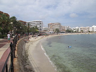
Santa Eulària des Riu is a coastal town on the south eastern seaboard of the Spanish island of Ibiza. The town is located on the designated road PM 810. Santa Eulària is the third largest town on the island and also has the only river on the island which flows into the sea at the western end of the town.

Portinatx is a small urbanization, formerly a very small fishing village, on the island of Ibiza. It is located 40 minutes from the island airport in the municipality of Sant Joan de Labritja and is the most northern bay on the island.

Cala de Sant Vicent is a beach resort village on the Spanish island of Ibiza. The resort is in the municipality of Sant Joan de Labritja. The resort is reached along the designated roads PMV 811 east from Sant Joan de Labritja, and on the PM 810 north from Santa Eulària des Riu. The resort is 18.9 miles (30.4 km) north east of Ibiza Town and 23.5 miles (37.8 km) of Ibiza Airport. The resort is 3.0 kilometres (1.9 mi) along a valley, east of the small community of Sant Vicent de sa Cala.

Sant Carles de Peralta is a village in the north east of Ibiza, Spain. The village is in the municipality of Santa Eulària des Riu and is located on the designated road PM 810. The village is 21.6 miles (34.8 km) North East of Ibiza Town and 28.3 miles (45.5 km) of Ibiza Airport. 5.0 kilometres (3.1 mi) to the South east of the village is the coastal resort of Es Canar.
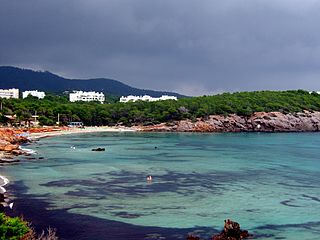
Es Canar is a beach resort village on the Spanish island of Ibiza. The resort is in the municipality of Santa Eulària des Riu. The resort is reached along the street called Cami d'Escana from Santa Eulària des Riu. The resort is 12.4 miles (20.0 km) north east of Ibiza Town and 16.9 miles (27.2 km) of Ibiza Airport. The resort is 3.4 miles (5.5 km) along the coast, east of Santa Eulària des Riu. By Taxi or tourist bus the journey time from the airport is approximately 40 minutes.

Cala Xuclar is a beach in the northern part of the Spanish island of Ibiza. It is in the municipality of Sant Joan de Labritja and is 3.8 miles (6.1 km) north of the village of Sant Joan de Labritja, and 1.2 miles (1.9 km) west of the beach resort of Portinatx.

Cala Pada is a beach on the south east seaboard of the Spanish island of Ibiza. It is in the municipality of Santa Eulària des Riu and is 2.7 miles (4.3 km) east of the town of Santa Eulària des Riu, and 1.9 miles (3.1 km) south west of the beach resort of Es Canar.

Platja des Niu Blau is a beach in the south east seaboard of the Spanish island of Ibiza. It is in the municipality of Santa Eulària des Riu and is 1.4 miles (2.3 km) east of the town of Santa Eulària des Riu, and 2.0 miles (3.2 km) west of the beach resort of Es Canar.

Platja Es Canar is the main beach within the beach resort of Es Canar which is on the south east seaboard of the Spanish island of Ibiza. It is in the municipality of Santa Eulària des Riu

Rigoberto Soler Pérez (1896–1968) was a Spanish post-Impressionist painter.

Agua Blanca is a beach on the Spanish island of Ibiza. It is in the municipality of Santa Eulària des Riu and is 6.4 miles (10.3 km) north east of the town of Santa Eulària des Riu. The nearest village is Sant Carles de Peralta which is 2.4 miles (3.9 km) south west of the beach. The name Agua Blanca means "white water" and refers to the choppy white horse’s on the sea caused by often blowing winds. Agua Blanca like many of the beaches along this north east section of the island remain empty for most of the year.

Sa Caleta is a cove on the south west seaboard of the Spanish island of Ibiza. The cove is in the municipality of Sant Josep de sa Talaia and is 6.8 miles (10.9 km) west of the town of Ibiza town. The village of Sant Josep de sa Talaia is 5.7 miles (9.2 km) east of the cove.

S'Argamassa Roman Fish Farm can be found 2.8 miles (4.5 km) eastwards along the coast from the town of Santa Eulària des Riu on the Spanish island of Ibiza. It is in the municipality of Santa Eulària des Riu. the Romans built this fish farm and connecting aqueduct following their occupation of the island in 146 BC.

Ses Balandres is a rocky cove with a very small beach on the western seaboard of the Spanish island of Ibiza. It is 1.2 miles (1.9 km) directly north of the village of Santa Agnès de Corona within the municipality of Sant Antoni de Portmany.

Cala Vadella is a small cove and beach resort the western seaboard of the Spanish island of Ibiza. The beach resort is in the municipality of Sant Josep de sa Talaia and is 14.5 miles (23.3 km) west of the town of Ibiza town. The nearest village of Sant Josep de sa Talaia is 5.3 miles (8.5 km) east of the beach resort. In 2012 Cala Vadella is one of the 12 blue flag beaches on Ibiza.

Port d’es Torrent is in a small cove within the bay of Sant Antoni Bay. The beach is on the northern seaboard of the Spanish island of Ibiza. Although it is but a short distance from Sant Antoni, it is in the municipality of Sant Josep de sa Talaia. Platja d’es Torrent is 12.6 miles (20.3 km) north west of Ibiza town, and 3.6 miles (5.8 km) west around the bay from Sant Antoni. In 2012 Port d’es Torrent is one of the 12 blue flag beaches on the island.

Cala d'Albarca is a cove on the northern seaboard of the Spanish island of Ibiza. The cove is situated within the municipality Sant Antoni de Portmany. It is 4.0 miles (6.4 km) north east of the village of Santa Agnès de Corona and 14.0 miles (22.5 km) north of Ibiza Town.

Pont Vell is the ancient bridge which crosses the Riu de Santa Eulària, the only river on the Spanish island of Ibiza. The bridge stands next to the modern road bridge on the western approach to the town of Santa Eulària des Riu. Today the bridges is only used as a footbridge with all other traffic restricted to the adjacent modern bridge.
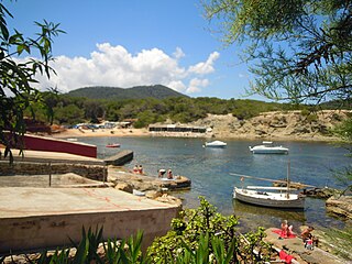
Platja Pou d'es Lleo is a beach on the north east seaboard of the Spanish island of Ibiza. It is in the municipality of Santa Eulària des Riu and is 11.8 kilometres (7.3 mi) north-east of the town of Santa Eulària des Riu, and 6.3 kilometres (3.9 mi) east of the village of San Carlos.


