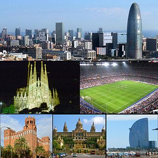
La Rambla is a street in central Barcelona. A tree-lined pedestrian street, it stretches for 1.2 kilometres (0.75 mi) connecting Plaça de Catalunya in the centre with the Christopher Columbus Monument at Port Vell. La Rambla forms the boundary between the quarters of Barri Gòtic, to the east, and El Raval, to the west.

The Gothic Quarter is the centre of the old city of Barcelona. It stretches from La Rambla to Via Laietana, and from the Mediterranean seafront to the Ronda de Sant Pere. It is a part of Ciutat Vella district.

The Barcelona Museum of Contemporary Art is situated in the Plaça dels Àngels, in El Raval, Ciutat Vella, Barcelona, Catalonia, Spain. The museum opened to the public on November 28, 1995. Previous directors were Daniel Giralt-Miracle (1988–1994), Miguel Molins (1995–1998), Manuel J. Borja-Villel (1998–2007), and Bartomeu Marí (2008-2015), while the current director, since 2015 is Ferran Barenblit.

Gran Via de les Corts Catalanes, more simply known as Gran Via[ˈɡɾam ˈbi.ə], is one of Barcelona's major avenues. With a length of 13.1 km (8.1 mi), it is the longest street in Catalonia and the 2nd longest in Spain, after Gran Vía de la Manga, in La Manga del Mar Menor, but is the one with more street numbers in Spain.
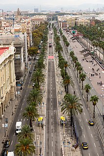
Plaça de Catalunya is a large square in central Barcelona that is generally considered to be both its city centre and the place where the old city and the 19th century-built Eixample meet.

Plaça de les Glòries Catalanes, most often shortened to Glòries, is a large square in Barcelona, first designed by Ildefons Cerdà to serve as the city centre in his original urban plan, but nowadays relegated to quite a secondary position. It is located in the Sant Martí district, bordering Eixample, at the junction of three of the city's most important thoroughfares: Avinguda Diagonal, Avinguda Meridiana and Gran Via de les Corts Catalanes. Currently it serves largely as a roundabout of elevated highways. However, beginning in the early 2000s, and as of 2007, revamping project for Glòries has started, which is aimed to give the square a new role in Barcelona and revitalize the northern districts of the city, under the name 22@. These plans supplement other large-scale plans in Sagrera and the Fòrum area. The first installment of this project was the construction of the controversial Torre Agbar skyscraper.

Plaça de Lesseps is a square serving as the border between the Sarrià-Sant Gervasi and Gràcia district of Barcelona, Catalonia, Spain, loosely divided in two parts. One of the most heavily transited squares in the city, Lesseps is the starting point of one of Barcelona's busiest rondes: Ronda del General Mitre, as well as being the west end of Carrer Gran de Gràcia and being crossed by a number of streets, namely: Travessera de Dalt, Avinguda del Príncep d'Astúries, Avinguda de Vallcarca, Avinguda de la República Argentina, Carrer del Torrent de l'Olla, Carrer de la Mare de Déu del Coll, Carrer de Santa Perpètua, Carrer de Maignon and Carrer de Pérez Galdós.

The Barcelona–Vallès Line is an unconnected standard gauge railway line linking Barcelona with Sabadell and Terrassa via the Collserola mountain range, in Catalonia, Spain. Its name refers to the Catalan historical region of Vallès, whereby most part of the line runs. Plaça de Catalunya station serves as the Barcelona terminus of the line, where almost all its trains either start or terminate. The line then continues northwards and branches off twice before leaving the city limits. Its main route splits in two in Sant Cugat del Vallès, forming two major branches to Sabadell and Terrassa. It has 40 passenger stations in operation and a total line length of 48.1 kilometres (29.9 mi).

Plaça de Francesc Macià is a square in Barcelona, Catalonia, Spain. Located in one of the main business areas of the city, it is one of the most transited points of Barcelona. It is crossed by Avinguda Diagonal and several other major thoroughfares: Avinguda de Josep Tarradellas, Travessera de Gràcia, Carrer del Comte d'Urgell and Avinguda de Pau Casals. It is part of the Sarrià-Sant Gervasi district, even though it borders two other districts of Barcelona: Les Corts and Eixample.
Plaça d'Ildefons Cerdà is a square in Barcelona, part of La Bordeta, in the Sants-Montjuïc district, very close to the boundary of the municipality of L'Hospitalet de Llobregat. It's named after the city's renowned urban planner Ildefons Cerdà. It is essentially a large roundabout which connects different parts of the city. The new courts of Barcelona and L'Hospitalet de Llobregat, collectively known under the name Ciutat de la Justícia are located in the immediacy of this square. Recent redevelopment has changed the area's feel, as well as promotion of the different Fira de Barcelona venues, not far from the square. Decisions made by recent urbanists has been criticised as a place hostile to strollers and therefore quite different from the idea of Barcelona an urbanist like Ildefons Cerdà had. A monument to Cerdà by sculptor Antoni Riera Clavillé was inaugurated in 1959, one century after his original urban plan, but was removed shortly after General Jorge Vigón, the Francoist Minister of Public Works, dismissed it publicly. There is no name plate in the square, which makes it theoretically a nameless space.

Plaça Reial is a square in the Barri Gòtic of Barcelona, Catalonia, Spain. It is close to La Rambla, and is a popular tourist attraction, especially at night. On the plaza are a large number of restaurants and some of the city's most famous nightclubs, including Sidecar, Jamboree, and Karma. The square is the site of the Hotel Roma Reial and is also known for its many outdoor venues. It is a popular meeting place during the summer, during the annual La Mercè festival in September when open-air concerts take place, and during other celebrations such as New Year's Eve.
Plaça de Gal·la Placídia is a square split between the districts of Gràcia and Sarrià-Sant Gervasi, in Barcelona, Catalonia, Spain. Its exact location is between Travessera de Gràcia, Carrer de Neptú, Carrer de Milton, Carrer de l'Oreneta and Via Augusta.
Ronda de la Universitat is a major thoroughfare of central Barcelona, Catalonia, Spain, in lower side of the Dreta de l'Eixample, in the Eixample district. It links two of the city's three main squares, running from Plaça de Catalunya towards Plaça Universitat. There it meets Gran Via de les Corts Catalanes and Ronda de Sant Antoni begins. It's essentially the same street as Ronda de Sant Pere, which follows it right after Plaça de Catalunya. As the other ronda, it follows the original outline of the medieval city walls, particularly the wall of Tallers, above the area nowadays known as Raval, where a road called Carrer de Tallers runs partially parallel to it. Ronda de la Universitat was paved in 1872. It takes its name from the Universitat de Barcelona, which has had its main building at Plaça Universitat since the 19th century. Before its current name was approved in 1989, its official name was in Spanish: Universidad. The Biblioteca Judicial de Catalunya is on this street.

Plaça de Mossèn Jacint Verdaguer is a square in the Eixample district of Barcelona, Catalonia, Spain. It lies in the intersection between Avinguda Diagonal, the city's main avenue, and Passeig de Sant Joan, in Dreta de l'Eixample, not far from the Sagrada Família.

El Putget i Farró is a neighbourhood in the Sarrià-Sant Gervasi district of Barcelona, Catalonia (Spain), located on a hill between Vallcarca and Sant Gervasi, urbanised after the 1870s. It is formed by two quarters, the former neighborhoods of el Putget and el Farró.

The Palau Reial Major is a complex of historic buildings located in Plaça del Rei, Barcelona, Catalonia, Spain. It was a residence of the counts of Barcelona and later, of the Kings of Aragon. It is composed of three distinct edifices:

Plaça del Rei is a 14th-century medieval public square in the Barri Gòtic of Barcelona, Spain.

Plaça dels Països Catalans is a square in Barcelona on one side of the city's central railway station, Estació de Sants, in the district of Sants-Montjuïc. It borders carrer de Tarragona, carrer de Numància and Avinguda Roma. It was so named in 1989 after the Catalan Countries.

The Barcelona City History Museum is a city museum that conserves, researches, communicates and exhibits the historical heritage of the city of Barcelona, from its origins in Roman times until the present day; it is funded by the Barcelona municipality. The museum's headquarters are located on Plaça del Rei, in the Barcelona Gothic Quarter. It also manages several historic sites all around the city, most of them archaeological sites displaying remains of the ancient Roman city, called Barcino in Latin. Some others date to medieval times, including the Jewish quarter and the medieval royal palace called the Palau Reial Major. The rest are contemporary, among them old industrial buildings and sites related to Antoni Gaudí and the Spanish Civil War. The museum was inaugurated on 14 April 1943; its principal promoter and first director was the historian Agustí Duran i Sanpere.

The Sarrià Capuchins are a community of the Capuchins that settled in Barcelona in 1578 after a request of the Consell de Cent, and against the will of the king Philip II.