Pleasant Hill, Nebraska | |
|---|---|
 Pleasant Hill, Nebraska  Pleasant Hill, Nebraska | |
| Coordinates: 40°35′12″N97°04′54″W / 40.58667°N 97.08167°W | |
| Country | |
| State | |
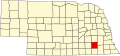
| County | Saline |
Pleasant Hill was an unincorporated community in Saline County, Nebraska, United States. [1] The community was southwest of Crete and lay between Turkey Creek to the north and Spring Creek to the south. [2] From 1871 to 1878 Pleasant Hill was the Saline County seat. Its peak population was 246 in 1900. [3]