Walla Walla County is a county located in the southeast of the U.S. state of Washington. As of the 2020 census, its population was 62,584. The county seat and largest city is Walla Walla. The county was formed on April 25, 1854 and is named after the Walla Walla tribe of Native Americans.

Burbank is a census-designated place (CDP) in Walla Walla County, Washington, United States, where the Snake River meets the Columbia. The population was 3,291 at the 2010 census. Named for Luther Burbank, the city is located just east of Pasco and Kennewick, across the Snake and Columbia Rivers, respectively. Burbank is part of the Tri-Cities, WA urban area, despite being located in the Walla Walla metropolitan area.
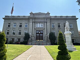
Walla Walla is a city in and the county seat of Walla Walla County, Washington, United States. It had a population of 34,060 at the 2020 census, estimated to have decreased to 33,339 as of 2023. The population of the city and its two suburbs, the town of College Place and unincorporated Walla Walla East, is about 45,000.
Ferndale is an unincorporated community in Umatilla County, Oregon, United States. It is near the Oregon–Washington border east of Oregon Route 339 and west of Oregon Route 11 about 4 miles (6 km) north of Milton-Freewater.

Sylvester Clark Smith was an American lawyer and politician. A Republican, he served four terms (1905–1913) as a U.S. Representative from California.

Washington Township is a township in Jewell County, Kansas, USA. As of the 2000 census, its population was 50.
Attalia is an extinct town in Walla Walla County, Washington. The GNIS classifies it as a populated place. Attalia was located on the East shore of the Columbia River some 8 miles downriver from Burbank.
The Pleasant River is a river in Washington County, Maine. From the outflow of Pleasant River Lake in Beddington, the river runs 44.8 miles (72.1 km) south, east, and south to Pleasant Bay. The river's mouth is on the border between the towns of Harrington and Addison.
The West Branch Pleasant River is a tributary of the Pleasant River in Washington County, Maine. From the confluence of Branch Brook and Bells Brook in southeast Columbia, the river meanders 2.3 miles (3.7 km) south to the estuary of the Pleasant River at Addison.
McNary National Wildlife Refuge is a wildlife preserve, one of the national wildlife refuges operated by the United States Fish and Wildlife Service. Extending along the east bank of the Columbia River in southeastern Washington, from the confluence of the Snake River to the mouth of the Walla Walla River, and downstream into Oregon, McNary NWR is located in rural Burbank, but very close to the rapid development of the Tri-Cities. In fact, the refuge meets the definition of an "urban refuge." Few areas in North America support waterfowl populations in the extraordinary numbers found here. There are spectacular concentrations of Canada geese, mallards, and other waterfowl. More than half the mallards in the Pacific Flyway overwinter at some time in this portion of the Columbia River Basin.

Penrose Point State Park is a 165-acre (67 ha) Washington state park located on Mayo Cove and Carr Inlet at the southern end of Puget Sound in Pierce County. The park has over 2 miles (3.2 km) of saltwater shoreline as well as 2.5 miles (4.0 km) of hiking and biking trails and an interpretive nature trail. Park activities include picnicking, boating, scuba diving, fishing, swimming, waterskiing, clam digging, crabbing, beachcombing, birdwatching, wildlife viewing, and horseshoes. The park was named after Stephen Penrose, the president of Whitman College in Walla Walla from 1884 to 1934.
Walla Walla is an unincorporated community in Cumberland County, Illinois, United States. Walla Walla is 3 miles (4.8 km) east-southeast of Jewett.
Yellepit was an unincorporated community in Benton County, Washington, United States, located approximately three miles southwest of Wallula on the west bank of the Columbia River.
Pleasant View is a census-designated place (CDP) in Armstrong County, Pennsylvania, United States. The population was 677 at the 2020 census. Pleasant View was formerly part of the census-designated place of North Vandergrift-Pleasant View at the 2000 Census, before splitting into two separate CDPs for the 2010 census.
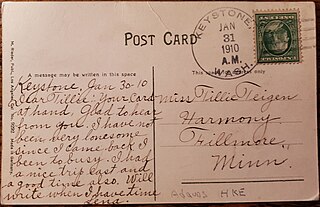
Keystone was a town in Adams County, Washington. It is located on the Northern Pacific Railroad, 16 miles NE of Ritzville and 10 miles SW of Sprague. The community was named after Pennsylvania, the Keystone State, the former home of an early postmaster.

Fort Colville was a U.S. Army post in the Washington Territory located three miles (5 km) north of current Colville, Washington. During its existence from 1859 to 1882, it was called "Harney's Depot" and "Colville Depot" during the first two years, and finally "Fort Colville". Brigadier General William S. Harney, commander of the Department of Oregon, opened up the district north of the Snake River to settlers in 1858 and ordered Brevet Major Pinkney Lugenbeel, 9th Infantry Regiment to establish a military post to restrain the Indians lately hostile to the U.S. Army's Northwest Division and to protect miners who flooded into the area after first reports of gold in the area appeared in Western Washington newspapers in July 1855.
Pleasant View is an unincorporated community in Moral Township, Shelby County, in the U.S. state of Indiana.
Eureka is an unincorporated community in Walla Walla County, in the U.S. state of Washington.
Theon was a town in Asotin County, Washington.


