Related Research Articles
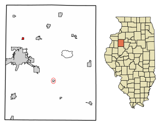
Henderson is a village in Knox County, Illinois, United States. The population was 255 at the 2010 census, down from 319 at the 2000 census. It is part of the Galesburg Micropolitan Statistical Area.
McKeansburg is a census-designated place (CDP) in Schuylkill County, Pennsylvania, United States. The population was 155 at the 2000 census.

High Bridge is a census-designated place (CDP) in Snohomish County, Washington, United States. The population was 2,994 at the 2010 census. High Bridge includes the Echo Lake community and the former Echo Lake CDP, which was superseded by the larger High Bridge CDP in 2010.

Ergoiena is a municipality located in the province and autonomous community of Navarre, northern Spain. The Basque municipality numbers three villages, Lizarraga, Unanu and Dorrao. It bounds with the range Urbasa on the west and south, and with Andia on the east.

Leandro Ferreira is a Brazilian municipality located in the center of the state of Minas Gerais. Its population as of 2020 was 3,226 people living in a total area of 355 km2 (137 sq mi). The city belongs to the meso-region of Central Mineira and to the micro-region of Bom Despacho. It became a municipality in 1963.

The Military Ridge State Trail is a 40-mile (64 km) long, recreational rail trail in Wisconsin.

Nottoway, or Nottoway Court House, is a census-designated place (CDP) in and the county seat of Nottoway County, Virginia, United States. The population as of the 2010 Census was 84.

Coronel Xavier Chaves is a Brazilian municipality located in the state of Minas Gerais. The city belongs to the mesoregion of Campo das Vertentes and to the microregion of São João del-Rei. In 2021, the estimated population was 3,488.

São Sebastião da Vargem Alegre is a Brazilian municipality located in the state of Minas Gerais. The city belongs to the mesoregion of Zona da Mata and to the microregion of Muriaé. As of 2020, the estimated population was 3,024.

Cierznie is a village in the administrative district of Gmina Debrzno, within Człuchów County, Pomeranian Voivodeship, in northern Poland. It lies approximately 12 kilometres (7 mi) west of Debrzno, 22 km (14 mi) south-west of Człuchów, and 136 km (85 mi) southwest of the regional capital Gdańsk. It is located within the historic region of Pomerania.
The Anamu River is a river of Pará state in north-central Brazil.
The Cafuini River is a river of Pará state in north-central Brazil.
The Popple River (Minnesota) is a river of Minnesota.
Mulungu, Paraíba is a municipality in the state of Paraíba in the Northeast Region of Brazil.

Presidente Vargas is a municipality in the state of Maranhão in the Northeast region of Brazil.
Ipiranga, Paraná is a municipality in the state of Paraná in the Southern Region of Brazil.

Batalha is a municipality in the state of Piauí in the Northeast region of Brazil.
References
Coordinates: 01°01′26″N57°04′19″W / 1.02389°N 57.07194°W