
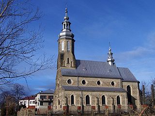
Dobra is a village in Limanowa County, Lesser Poland Voivodeship, in southern Poland. It is the seat of the gmina called Gmina Dobra. It lies approximately 13 kilometres (8 mi) west of Limanowa and 45 km (28 mi) south-east of the regional capital Kraków.

Gruszowiec is a village in the administrative district of Gmina Dobra, within Limanowa County, Lesser Poland Voivodeship, in southern Poland. It lies approximately 5 kilometres (3 mi) west of Dobra, 17 km (11 mi) west of Limanowa, and 45 km (28 mi) south-east of the regional capital Kraków.

Jurków is a village in the administrative district of Gmina Dobra, within Limanowa County, Lesser Poland Voivodeship, in southern Poland. It lies approximately 4 kilometres (2 mi) south of Dobra, 15 km (9 mi) west of Limanowa, and 47 km (29 mi) southeast of the regional capital Kraków.
Przenosza is a village in the administrative district of Gmina Dobra, within Limanowa County, Lesser Poland Voivodeship, in southern Poland. It lies approximately 9 kilometres (6 mi) north-west of Dobra, 21 km (13 mi) west of Limanowa, and 37 km (23 mi) south-east of the regional capital Kraków.

Góra Świętego Jana is a village in the administrative district of Gmina Jodłownik, within Limanowa County, Lesser Poland Voivodeship, in southern Poland.
Janowice is a village in the administrative district of Gmina Jodłownik, within Limanowa County, Lesser Poland Voivodeship, in southern Poland. It lies approximately 2 kilometres (1 mi) north-west of Jodłownik, 18 km (11 mi) north-west of Limanowa, and 37 km (23 mi) south-east of the regional capital Kraków.
Krasne-Lasocice is a village in the administrative district of Gmina Jodłownik, within Limanowa County, Lesser Poland Voivodeship, in southern Poland. It lies approximately 5 kilometres (3 mi) north of Jodłownik, 19 km (12 mi) north-west of Limanowa, and 35 km (22 mi) south-east of the regional capital Kraków.
Pogorzany is a village in the administrative district of Gmina Jodłownik, within Limanowa County, Lesser Poland Voivodeship, in southern Poland. It lies approximately 5 kilometres (3 mi) west of Jodłownik, 21 km (13 mi) north-west of Limanowa, and 36 km (22 mi) south-east of the regional capital Kraków.
Bałażówka is a village in the administrative district of Gmina Limanowa, within Limanowa County, Lesser Poland Voivodeship, in southern Poland. It lies approximately 8 kilometres (5 mi) north-west of Limanowa and 46 km (29 mi) south-east of the regional capital Kraków.
Kisielówka is a village in the administrative district of Gmina Limanowa, within Limanowa County, Lesser Poland Voivodeship, in southern Poland. It lies approximately 9 kilometres (6 mi) north-west of Limanowa and 45 km (28 mi) south-east of the regional capital Kraków.
Koszary is a village in the administrative district of Gmina Limanowa, within Limanowa County, Lesser Poland Voivodeship, in southern Poland. It lies approximately 7 kilometres (4 mi) north-west of Limanowa and 48 km (30 mi) south-east of the regional capital Kraków.
Lipowe is a village in the administrative district of Gmina Limanowa, within Limanowa County, Lesser Poland Voivodeship, in southern Poland. It lies approximately 3 kilometres (2 mi) west of Limanowa and 51 km (32 mi) south-east of the regional capital Kraków.
Rupniów is a village in the administrative district of Gmina Limanowa, within Limanowa County, Lesser Poland Voivodeship, in southern Poland. It lies approximately 13 kilometres (8 mi) north-west of Limanowa and 42 km (26 mi) south-east of the regional capital Kraków.
Walowa Góra is a village in the administrative district of Gmina Limanowa, within Limanowa County, Lesser Poland Voivodeship, in southern Poland. It lies approximately 7 kilometres (4 mi) north-west of Limanowa and 47 km (29 mi) south-east of the regional capital Kraków.
Kasinka Mała is a village in the administrative district of Gmina Mszana Dolna, within Limanowa County, Lesser Poland Voivodeship, in southern Poland. It lies approximately 7 kilometres (4 mi) north-west of Mszana Dolna, 29 km (18 mi) west of Limanowa, and 39 km (24 mi) south of the regional capital Kraków.
Raba Niżna is a village in the administrative district of Gmina Mszana Dolna, within Limanowa County, Lesser Poland Voivodeship, in southern Poland. It lies approximately 4 kilometres (2 mi) south-west of Mszana Dolna, 29 km (18 mi) west of Limanowa, and 47 km (29 mi) south of the regional capital Kraków.

Konina is a village in the administrative district of Gmina Niedźwiedź, within Limanowa County, Lesser Poland Voivodeship, in southern Poland. It lies approximately 6 kilometres (4 mi) south-west of Niedźwiedź, 25 km (16 mi) south-west of Limanowa, and 53 km (33 mi) south of the regional capital Kraków.

Niedźwiedź is a village in Limanowa County, Lesser Poland Voivodeship, in southern Poland. It is the seat of the gmina called Gmina Niedźwiedź. It lies approximately 21 kilometres (13 mi) west of Limanowa and 51 km (32 mi) south of the regional capital Kraków.
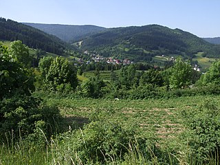
Poręba Wielka is a village in the administrative district of Gmina Niedźwiedź, within Limanowa County, Lesser Poland Voivodeship, in southern Poland. It lies approximately 8 kilometres (5 mi) west of Niedźwiedź, 29 km (18 mi) west of Limanowa, and 51 km (32 mi) south of the regional capital Kraków.


