Point Wolfe Bridge

Last updated
Point Wolfe Bridge
Point Wolfe Bridge1.jpg
Coordinates 45°33′02″N65°0′47″W / 45.55056°N 65.01306°W / 45.55056; -65.01306
CrossesPoint Wolfe River
Characteristics
DesignCovered
MaterialWood
Total length28.8 m (94 ft) [1]
History
Built1909
Opened1910
Rebuilt1992
Location
Point Wolfe Bridge

The Point Wolfe Bridge is a red covered bridge that crosses the Point Wolfe River at Fundy National Park in New Brunswick, Canada. It is one of the two covered bridges in Fundy National Park, [2] connecting the Point Wolfe Road from the Point Wolfe campground to the rest of the park. [3] It was originally built in 1909, following the collapse of a bridge one year prior. The Point Wolfe Bridge was once again rebuilt in 1992 after a workplace accident in December 1990 resulted in the bridge collapsing.

Contents

History

Since 1853, there have been a total of five bridges that have stood in the location of Point Wolfe Bridge. [4] One of these bridges fell in 1908, [5] was rebuilt in 1909, [6] and opened in 1910 at a cost of $1,456. [5] The Point Wolfe Bridge predates Fundy National Park, which was created on April 10, 1948, and officially opened on July 29, 1950. [7]

On December 29, 1990, the Point Wolfe Bridge collapsed when workers tried removing rock that posed a safety risk to the bridge. [2] [8] As they were using explosives to remove the rock, a chunk knocked the bridge, causing it to collapse. [9] Shortly following the accident, the federal government announced that they would be rebuilding the bridge with close resemblance to the former one, [10] with a temporary bridge being used in the meantime. [11] In 1992, it was rebuilt at a cost of CA$545,000. [2]

See also

Related Research Articles

<span class="mw-page-title-main">Saint John, New Brunswick</span> City in New Brunswick, Canada

Saint John is a seaport city located on the Bay of Fundy in the province of New Brunswick, Canada. It is Canada's oldest incorporated city, established by royal charter on May 18, 1785, during the reign of George III. The port is Canada's third-largest by tonnage with a cargo base that includes dry and liquid bulk, break bulk, containers, and cruise. The city was the most populous in New Brunswick until the 2016 census, when it was overtaken by Moncton. It is currently the second-largest city in the province, with a population of 69,895 over an area of 315.59 km2 (121.85 sq mi).

<span class="mw-page-title-main">Hartland, New Brunswick</span> Town in New Brunswick, Canada

Hartland is a town in Carleton County, New Brunswick, Canada.

<span class="mw-page-title-main">Fundy National Park</span> Located on the Bay of Fundy, near the village of Alma, New Brunswick

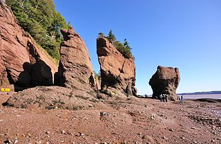
Fundy National Park is a national park of Canada located on the Bay of Fundy, near the village of Alma, New Brunswick. It was created on April 10, 1946 and officially opened on July 29, 1950. The park showcases a rugged coastline which rises up to the Canadian Highlands, the highest tides in the world and more than 25 waterfalls. The park covers an area of 207 km2 (80 sq mi) along Goose Bay, the northwestern branch of the Bay of Fundy. When one looks across the Bay, one can see the northern Nova Scotia coast.

Deer Island is one of the Fundy Islands in the Bay of Fundy, Canada. It is at the entrance to Passamaquoddy Bay. The island was first settled by colonists around 1770.

<span class="mw-page-title-main">Alma, New Brunswick</span> Place in New Brunswick, Canada

Alma is a disincorporated Village in Fundy Albert, New Brunswick, Canada. It resides in the territorial divisions of parish of Alma, Albert County. Alma is centered on the small delta of the Upper Salmon River and Cleveland Brook, where they empty into Salisbury Bay.

<span class="mw-page-title-main">St. Martins, New Brunswick</span> Place in New Brunswick, Canada

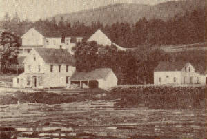
St. Martins is a community on the Bay of Fundy now part of the village of Fundy-St. Martins, Canada.

<span class="mw-page-title-main">Beaver Harbour, New Brunswick</span> Local service district in New Brunswick, Canada

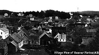
Beaver Harbour is a community on the Fundy shore of New Brunswick, Canada.

<span class="mw-page-title-main">Blaine Higgs</span> Premier of New Brunswick since 2018

Blaine Myron Higgs is a Canadian politician who is the 34th and current premier of New Brunswick since 2018 and leader of the New Brunswick Progressive Conservative Party since 2016.

<span class="mw-page-title-main">Fundy Biosphere Reserve</span> UNESCO Biosphere Region in New Brunswick, Canada

The Fundy Biosphere Region is located next to the upper Bay of Fundy, covering 442,250 hectares in New Brunswick, Canada. The area was named and designated as such by the United Nations Educational, Scientific and Cultural Organization (UNESCO) in 2007.

<span class="mw-page-title-main">Alma Parish, New Brunswick</span> Parish in New Brunswick, Canada

Alma is a geographic parish on the Bay of Fundy in the southwestern corner of Albert County, New Brunswick, Canada.

<span class="mw-page-title-main">Hammond Parish, New Brunswick</span> Parish in New Brunswick, Canada

Hammond is a geographic parish in Kings County, New Brunswick, Canada.

<span class="mw-page-title-main">Saint Martins Parish, New Brunswick</span> Parish in New Brunswick, Canada

Saint Martins is a geographic parish in Saint John County, New Brunswick, Canada.

<span class="mw-page-title-main">Alaina Lockhart</span> Canadian politician

Alaina Lockhart MP is a Canadian Liberal politician who represented the riding of Fundy Royal in the House of Commons of Canada from 2015 to 2019. She took on the role of Parliamentary Secretary to Small Business and Tourism, as well as Official Languages and La Francophonie. She has served as a member of the Agriculture and Agri-food Standing Committee, and the Veterans Affairs Standing Committee. Lockhart did not win her seat again in the 2019 Canadian federal election and lost her seat to Rob Moore.

<span class="mw-page-title-main">Gannet Rock Lighthouse</span> Lighthouse

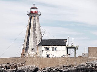
The Gannet Rock Lighthouse is a Canadian lighthouse located on a rocky islet 8 miles (13 km) south of Grand Manan in the Bay of Fundy. It was first lit in 1831 and was staffed until 1996. It was solarized in 2002 and remains operational in 2023. It was declared "surplus to requirements" by the Canadian Coast Guard in 2010 and is no longer being maintained.

<span class="mw-page-title-main">Swallowtail Lighthouse</span> Lighthouse

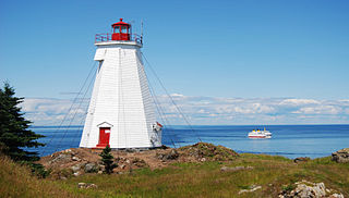
The Swallowtail Lighthouse is a Canadian lighthouse located on Grand Manan Island in the Bay of Fundy. It was the first lighthouse to be built on the island. It was first lit on 7 July 1860 and was automated and de-staffed in 1986.

<span class="mw-page-title-main">Long Eddy Point Lighthouse</span> Lighthouse

The Long Eddy Point Lighthouse is a Canadian lighthouse on Grand Manan Island in the Bay of Fundy. The navigation station was first established in 1874 as a fog alarm only and operated as such until 1966, when the present structure was built incorporating a lighthouse. The building has been designated a heritage lighthouse under Canada's Heritage Lighthouse Protection Act.

<span class="mw-page-title-main">Administrative divisions of New Brunswick</span> Local governance in New Brunswick

The Canadian province of New Brunswick is divided into 89 local entities, consisting of 77 local governments and 12 rural districts.

<span class="mw-page-title-main">Point Wolfe</span> Abandoned village in New Brunswick, Canada

Point Wolfe is a former Canadian village in Albert County, New Brunswick. It is currently a campground location at Fundy National Park.

References

  1. Government of New Brunswick, Canada (11 October 2011). "Albert County - Covered Bridge". www2.gnb.ca. Retrieved 12 April 2024.
  2. 1 2 3 "Province's covered bridges delight artists". The Boston Globe . 16 May 1993. p. 226. Retrieved 12 April 2024.
  3. Parks Canada Agency, Government of Canada (15 March 2023). "Point Wolfe". parks.canada.ca. Retrieved 12 April 2024.
  4. Miller, Jenna. "Coastal Climate Change Vulnerability and Adaptation in Fundy National Park, New Brunswick" (PDF). Retrieved 12 April 2024.
  5. 1 2 Gillis, Stephen (1988). No faster than a walk : the covered bridges of New Brunswick. Fredericton, N.B., Canada : Goose Lane Editions. p. 41. ISBN   978-0-86492-091-1 . Retrieved 12 April 2024.
  6. "Blasted bridge to be replaced". The Hamilton Spectator . 16 February 1991. p. 20. Retrieved 12 April 2024.
  7. Parks Canada Agency, Government of Canada (23 March 2023). "History". parks.canada.ca. Retrieved 12 April 2024.
  8. "Blasting error destroys Fundy's historic covered bridge". The Ottawa Citizen . 2 January 1991. p. 10. Retrieved 12 April 2024.
  9. "Historic covered bridge accidentally wrecked". The Sun Times . 2 January 1991. p. 11. Retrieved 12 April 2024.
  10. "Ottawa to replace N.B. bridge". The Gazette . 12 February 1991. p. 3. Retrieved 12 April 2024.
  11. "Bridge replaced". The Leader-Post . 13 February 1991. p. 48. Retrieved 12 April 2024.