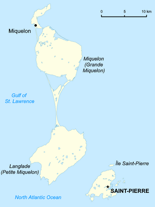
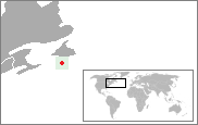
Saint Pierre and Miquelon, officially the Overseas Collectivity of Saint-Pierre and Miquelon, is a self-governing territorial overseas collectivity of France in the northwestern Atlantic Ocean, located near the Canadian province of Newfoundland and Labrador. An archipelago of eight islands, St. Pierre and Miquelon is a vestige of the once-vast territory of New France. Its residents are French citizens. The collectivity elects its own deputy to the National Assembly and participates in senatorial and presidential elections. It covers 242 km2 (93 sq mi) of land and had a population of 6,008 as of the March 2016 census.
Saint Pierre and Miquelon is a French overseas collectivity in the Western Hemisphere and the Northern Hemisphere. It consists of an island archipelago, off the coast of Newfoundland, near North America. The collectivity shares a maritime boundary with Canada.

The Gulf of St. Lawrence fringes the shores of the provinces of Quebec, New Brunswick, Nova Scotia, Prince Edward Island, Newfoundland and Labrador, in Canada, plus the islands Saint-Pierre and Miquelon, possessions of France, in North America.

Miquelon-Langlade is the larger but less populated of the two communes (municipalities) making up the French overseas collectivity of Saint Pierre and Miquelon, located 22 km (14 mi) to the south of Newfoundland in the Gulf of St. Lawrence. It consists of three geological islands: Miquelon, Langlade and Le Cap, connected with tombolos. The communal seat is the settlement of Miquelon, on the northern tip, where the entire island's permanent population of 580 is located. Miquelon Airport provides flights to Montreal and to nearby Saint-Pierre Airport.
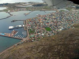
Saint-Pierre is the capital of the French overseas collectivity of Saint Pierre and Miquelon, off the coast of the Canadian island of Newfoundland. Saint-Pierre is the more populous of the two communes (municipalities) making up Saint Pierre and Miquelon.

The Battle of the Thousand Islands was an engagement fought on 16–24 August 1760, in the upper St. Lawrence River, among the Thousand Islands, along the present day Canada–United States border, by British and French forces during the closing phases of the Seven Years' War, as it is called in Canada and Europe, or the French and Indian War as it is referred to in the United States.

Île aux Noix is an island on the Richelieu River in Quebec, close to Lake Champlain. The island is the site of Fort Lennox National Historic Site of Canada. Politically, it is part of Saint-Paul-de-l'Île-aux-Noix.

Fort Lévis, a fortification on the St. Lawrence River, was built in 1759 by the French. They had decided that Fort de La Présentation was insufficient to defend their St. Lawrence River colonies against the British. Named for François Gaston de Lévis, Duc de Lévis, the fort was constructed on Isle Royale, 3 miles (4.8 km) downstream from the other fort. The fort surrendered after intense bombardment in August 1760 to the British and was renamed Fort William Augustus. The fort was abandoned in 1766. During the construction of the Saint Lawrence Seaway, the remains of the fort were destroyed and submerged beneath the waters of the river.
Green Island is a rocky island near the mouth of Fortune Bay, Newfoundland. It is located about 10 km (6 mi) west of the Burin Peninsula of Newfoundland near Point May, and 10 km (6 mi) east of Saint Pierre Island in the French overseas collectivity of Saint Pierre and Miquelon.

Île-aux-Marins is a small uninhabited island located off the coast of Saint-Pierre and Miquelon.
Petit Bé is a tidal island near the city of Saint-Malo, France, close to the larger island of Grand Bé. At low tide one can walk to the island from the nearby Bon-Secours beach.

The following outline is provided as an overview of and topical guide to Saint Pierre and Miquelon:

The Fort de Bertheaume is a fort in Plougonvelin, in the Department of Finistère, France. It is located on a tidal island that nowadays connects to the mainland via a footbridge. The fort sits well above sea level, and its steep cliffs have rendered it easily defended for centuries. Since the 17th century, the fort's role has been to monitor the Goulet de Brest, the straits of Brest.
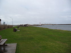
Saint Pierre Island, also spelt as Saint-Pierre Island, is one of the three main islands of Saint Pierre and Miquelon. It contains the town of Saint-Pierre, which lies on the island's east coast and is the main population centre of the island group. It is part of an overseas collectivity of France, and is located near the Canadian province of Newfoundland and Labrador.
The following is an alphabetical list of topics related to the French territorial collectivity of Saint Pierre and Miquelon.
Grand Barachois is a large natural lagoon in Saint Pierre and Miquelon. It lies immediately south of Miquelon Island, and is formed largely by the 12 kilometre-long tombolo of La Dune. There is an observatory on the shore of the lagoon called the Observatoire du Grand Barachois.

The Newfoundland expedition was a series of fleet manoeuvres and amphibious landings in the coasts of Newfoundland, Labrador and Saint Pierre and Miquelon carried out by the combined French and Spanish fleets during the French Revolutionary Wars. This expedition, composed of seven ships of the line and three frigates under the orders of Rear-Admiral Richery sailed from Cadiz in August 1796 accompanied by a much stronger Spanish squadron, commanded by General Solano, which had the aim of escorting it to the coast of Newfoundland.

Fort Pointe-aux-Trembles was a French fort built during the 17th century in New France.
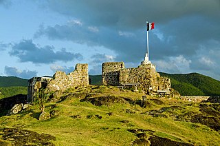
Fort Louis is a historic French military fort on the Caribbean island of Saint Martin. It is located in Marigot, the capital of the French side of the island, overlooking Marigot Bay. The fort was built in the 18th century to defend Marigot's harbor and its warehouses. It was built during the reign of King Louis XVI.

SPM Ferries is a company that operates ferries between the islands of Saint Pierre and Miquelon-Langlade in Saint Pierre and Miquelon, an overseas collectivity of France, and the port of Fortune, on the island of Newfoundland, Canada. It operates three vessels: