External links
| Authority control |
|
|---|
| | This Southwestern Ontario geographical article is a stub. You can help Wikipedia by expanding it. |
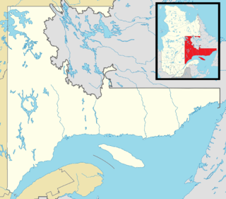
| Pointe aux Pins | |
|---|---|
| Nearest city | Blenheim, Ontario |
| Coordinates | 42°16′33.22″N81°51′26.31″W / 42.2758944°N 81.8573083°W Coordinates: 42°16′33.22″N81°51′26.31″W / 42.2758944°N 81.8573083°W |
Pointe aux Pins is a peninsula running south into Lake Erie at about 82 degrees west longitude. The majority of land which comprises the peninsula is owned by the province of Ontario and is designated as Rondeau Provincial Park. A navigational warning light is located near the tip of the peninsula at about 42 degrees, 15 minutes and 23.3 seconds North latitude, 81 degrees, 51 minutes and 6.5 seconds West longitude. The peninsula is designated as the Pointe aux Pins in the Atlas of Canada.
| Authority control |
|
|---|
| | This Southwestern Ontario geographical article is a stub. You can help Wikipedia by expanding it. |

A minute of arc, arcminute (arcmin), arc minute, or minute arc, denoted by the symbol , is a unit of angular measurement equal to 1/60 of one degree. Since one degree is 1/360 of a turn, one minute of arc is 1/21600 of a turn. The nautical mile was originally defined as a minute of latitude on a spherical Earth, so the actual Earth circumference is very near 21 600 nautical miles. A minute of arc is π/10800 of a radian.

ISO 6709, Standard representation of geographic point location by coordinates, is the international standard for representation of latitude, longitude and altitude for geographic point locations.

Rondeau Provincial Park is the second oldest provincial park in Ontario, Canada, having been established with an order in council on 8 September 1894. The park is located in Southwestern Ontario, on an 8 km long crescentic sand spit extending into Lake Erie. Rondeau is home to the largest area of Carolinian forest in Canada, a long sand beach, a large marsh, approximately half of Rondeau Bay, campgrounds and a cottage community. The name of the park comes from the French words "ronde eau" or "round water" which describes the shape of the harbour sheltered by the peninsula.

Burgeo-La Poile is a provincial electoral district for the House of Assembly of Newfoundland and Labrador, Canada. As of 2011, there are 7,527 eligible voters living within the district. The district was first created when Newfoundland joined confederation in 1949 as Burgeo and La Poile, and existed until 1975. It was recreated in 1995 following a reduction in the number of seats in the House of Assembly from 52 to 48, forming from the amalgamation of the former districts of La Poile and Burgeo-Bay D'Espoir.

Bois Blanc Island is an island in Lake Huron coterminous with Bois Blanc Township, Mackinac County, Michigan. The island covers about 34 sq mi (88 km2) and is about 12 miles (19 km) long, 6 miles (9.6 km) wide and has 6 lakes. It lies southeast of Mackinac Island and almost due north of the city of Cheboygan.
Decimal degrees (DD) express latitude and longitude geographic coordinates as decimal fractions of a degree. DD are used in many geographic information systems (GIS), web mapping applications such as OpenStreetMap, and GPS devices. Decimal degrees are an alternative to using sexagesimal degrees. As with latitude and longitude, the values are bounded by ±90° and ±180° respectively.

Au Cap is an administrative district of Seychelles located on the island of Mahé.

The Borden System is an archaeological numbering system used throughout Canada and by the Canadian Museum System to track archaeological sites and the artefacts that come from them.
There are several ways of determining the centre of Canada giving different locations.
Pointe-aux-Outardes is a village municipality in Quebec, Canada, on the southern point of the Manicouagan Peninsula between the mouths of the Outardes and Manicouagan Rivers.

A total solar eclipse will occur on May 1, 2079, with a maximum eclipse at 10:48:25.6 UTC. A solar eclipse occurs when the Moon passes between Earth and the Sun, thereby totally or partly obscuring the image of the Sun for a viewer on Earth. A total solar eclipse occurs when the Moon's apparent diameter is larger than the Sun's, blocking all direct sunlight, turning day into darkness. Totality occurs in a narrow path across Earth's surface, with the partial solar eclipse visible over a surrounding region thousands of kilometres wide. The eclipse will be visible in Greenland, parts of eastern Canada and parts of the northeastern United States.
The New Westminster Land District is one of 59 land districts of British Columbia, Canada, which are the underlying cadastral divisions of that province, created with rest of those on Mainland British Columbia via the Lands Act of the Colony of British Columbia in 1860. The British Columbia government's BC Names system, a subdivision of GeoBC, defines a land district as "a territorial division with legally defined boundaries for administrative purposes" All land titles and surveys use the Land District system as the primary point of reference, and entries in BC Names for placenames and geographical objects are so listed.
Pins is the plural of "pin", a fastening device.
The Comox Land District is one of the 59 land districts of British Columbia, Canada, which are part of the cadastral divisions of British Columbia, created with rest of those on Vancouver Island via the Lands Act of the Colony of Vancouver Island. The British Columbia government's BC Names system, a subdivision of GeoBC, defines a land district as "a territorial division with legally defined boundaries for administrative purposes". All land titles and surveys use the Land District system as the primary point of reference, and entries in BC Names for placenames and geographical objects are so listed.
The Rivière aux Pins is a tributary of the Beaurivage River which is a tributary of the west bank of the Chaudière River. It flows in the municipalities of Saint-Agapit and Saint-Gilles in the Lotbinière Regional County Municipality, in the administrative region of Chaudière-Appalaches, in Quebec, in Canada.
The rivière aux Pins is a tributary of the south shore of the Saint Lawrence River, flowing in the city of Boucherville, in the administrative region of Montérégie, southwest of province of Quebec, in Canada.
The Sabrevois River is a tributary of the south shore of the St. Lawrence River, flowing in the city of Boucherville, in the administrative region of Montérégie, southwest of province of Quebec, in Canada.
The rivière aux Iroquois is a tributary of lac Saint-Jean, flowing the municipality of Sainte-Hedwidge and Saint-Prime, in the Le Domaine-du-Roy Regional County Municipality, in the administrative region of Saguenay–Lac-Saint-Jean, in the province of Quebec, in Canada.

The rivière aux Ormes is a tributary of the east bank of the Huron River which constitutes a tributary of the south shore of the St. Lawrence River.
The Rivière Rouge is a tributary of the west shore of Beaurivage River which is a tributary of the west bank of the Chaudière River. It flows in the municipalities of Saint-Agapit and Saint-Apollinaire in the Lotbinière Regional County Municipality, in the administrative region of Chaudière-Appalaches, in Quebec, in Canada.