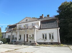
Skawina is a town in southern Poland with 27,328 inhabitants (2008). Situated in the Lesser Poland Voivodeship, previously in Kraków Voivodeship (1975–1998). The town is located on the Skawinka river, in close proximity to the city of Kraków. Its population was 23,761, and the area of the town is 20,50 km2. One of the most interesting historic buildings in Skawina is a Renaissance palace, built in the mid-16th century by Paweł Korytko. The name of the town probably comes from the Skawinka river.
Gmina Myślenice is an urban-rural gmina in Myślenice County, Lesser Poland Voivodeship, in southern Poland. Its seat is the town of Myślenice, which lies approximately 26 kilometres (16 mi) south of the regional capital Kraków.

Borek Szlachecki is a village in the administrative district of Gmina Skawina, within Kraków County, Lesser Poland Voivodeship, in southern Poland. It lies approximately 5 kilometres (3 mi) south-west of Skawina and 16 km (10 mi) south-west of the regional capital Kraków.
Gołuchowice is a village in the administrative district of Gmina Skawina, within Kraków County, Lesser Poland Voivodeship, in southern Poland. It lies approximately 6 kilometres (4 mi) south-west of Skawina and 17 km (11 mi) south-west of the regional capital Kraków.
Grabie is a village in the administrative district of Gmina Skawina, within Kraków County, Lesser Poland Voivodeship, in southern Poland. It lies approximately 9 kilometres (6 mi) south-west of Skawina and 20 km (12 mi) south-west of the regional capital Kraków.
Jaśkowice is a village in the administrative district of Gmina Skawina, within Kraków County, Lesser Poland Voivodeship, in southern Poland. It lies approximately 11 kilometres (7 mi) west of Skawina and 22 km (14 mi) south-west of the regional capital Kraków.
Kopanka is a village in the administrative district of Gmina Skawina, within Kraków County, Lesser Poland Voivodeship, in southern Poland. It lies approximately 4 kilometres (2 mi) west of Skawina and 15 km (9 mi) south-west of the regional capital Kraków.
Krzęcin is a village in the administrative district of Gmina Skawina, within Kraków County, Lesser Poland Voivodeship, in southern Poland. It lies approximately 8 kilometres (5 mi) south-west of Skawina and 19 km (12 mi) south-west of the regional capital Kraków.
Ochodza is a village in the administrative district of Gmina Skawina, within Kraków County, Lesser Poland Voivodeship, in southern Poland. It lies approximately 7 kilometres (4 mi) west of Skawina and 18 km (11 mi) south-west of the regional capital Kraków.
Pozowice is a village in the administrative district of Gmina Skawina, within Kraków County, Lesser Poland Voivodeship, in southern Poland. It lies approximately 10 kilometres (6 mi) west of Skawina and 20 km (12 mi) south-west of the regional capital Kraków.
Radziszów is a village in the administrative district of Gmina Skawina, within Kraków County, Lesser Poland Voivodeship, in southern Poland. It lies approximately 6 kilometres (4 mi) south of Skawina and 17 km (11 mi) south-west of the regional capital Kraków.
Rzozów is a village in the administrative district of Gmina Skawina, within Kraków County, Lesser Poland Voivodeship, in southern Poland. It lies approximately 5 kilometres (3 mi) south-west of Skawina and 16 km (10 mi) south-west of the regional capital Kraków.
Wielkie Drogi is a village in the administrative district of Gmina Skawina, within Kraków County, Lesser Poland Voivodeship, in southern Poland. It lies approximately 9 kilometres (6 mi) west of Skawina and 20 km (12 mi) south-west of the regional capital Kraków.
Wola Radziszowska is a village in the administrative district of Gmina Skawina, within Kraków County, Lesser Poland Voivodeship, in southern Poland. It lies approximately 9 kilometres (6 mi) south-west of Skawina and 20 km (12 mi) south-west of the regional capital Kraków.
Polanka is a village in the administrative district of Gmina Myślenice, within Myślenice County, Lesser Poland Voivodeship, in southern Poland. It lies approximately 4 kilometres (2 mi) north of Myślenice and 22 km (14 mi) south of the regional capital Kraków.

Kąśna Dolna is a village in the administrative district of Gmina Ciężkowice, within Tarnów County, Lesser Poland Voivodeship, in southern Poland. It lies approximately 6 kilometres (4 mi) south-west of Ciężkowice, 31 km (19 mi) south of Tarnów, and 78 km (48 mi) south-east of the regional capital Kraków.
Grabno is a village in the administrative district of Gmina Wojnicz, within Tarnów County, Lesser Poland Voivodeship, in southern Poland. It lies approximately 8 kilometres (5 mi) south-west of Wojnicz, 22 km (14 mi) south-west of Tarnów, and 62 km (39 mi) east of the regional capital Kraków.
Ryczów is a village in the administrative district of Gmina Spytkowice, within Wadowice County, Lesser Poland Voivodeship, in southern Poland. It lies approximately 12 kilometres (7 mi) north of Wadowice and 30 km (19 mi) west of the regional capital Kraków.
Polanka Wielka is a village in Oświęcim County, Lesser Poland Voivodeship, in southern Poland. It is the seat of the gmina called Gmina Polanka Wielka. It lies approximately 10 kilometres (6 mi) south-east of Oświęcim and 46 km (29 mi) west of the regional capital Kraków.