Related Research Articles

In physical geography, tundra is a type of biome where tree growth is hindered by frigid temperatures and short growing seasons. The term is a Russian word adapted from Sámi languages. There are three regions and associated types of tundra: Arctic tundra, alpine tundra, and Antarctic tundra.

The Arctic is a polar region located at the northernmost part of Earth. The Arctic region, from the IERS Reference Meridian travelling east, consists of parts of northern Norway, northernmost Sweden, northern Finland, Russia, the United States (Alaska), Canada, Danish Realm (Greenland), and northern Iceland, along with the Arctic Ocean and adjacent seas. Land within the Arctic region has seasonally varying snow and ice cover, with predominantly treeless permafrost under the tundra. Arctic seas contain seasonal sea ice in many places.
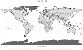
The polar climate regions are characterized by a lack of warm summers but with varying winters. Every month a polar climate has an average temperature of less than 10 °C (50 °F). Regions with a polar climate cover more than 20% of the Earth's area. Most of these regions are far from the equator and near the poles, and in this case, winter days are extremely short and summer days are extremely long. A polar climate consists of cool summers and very cold winters, which results in treeless tundra, glaciers, or a permanent or semi-permanent layer of ice. It is identified with the letter E in the Köppen climate classification.
Walter Brian Harland was a British geologist at the Department of Geology, later University of Cambridge Department of Earth Sciences, England, from 1948 to 2003. He was a leading figure in geological exploration and research in Svalbard, organising over 40 Cambridge Spitsbergen Expeditions (CSE) and in 1975 founded the Cambridge Arctic Shelf Programme (CASP) as a research institute to continue this work. He was first secretary of the International Geological Correlation Programme from 1969 until UNESCO could take over in 1972, and was a driving force in setting criteria and standards in stratigraphy and producing 4 editions of the geological time scale in 1964, 1971, 1982 and 1989. He also edited the international Geological Magazine for 30 years. In 1968, he was honoured with the Royal Geographical Society Gold Medal for Arctic exploration and research.
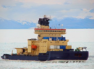
Oden is a large Swedish icebreaker, built in 1988 for the Swedish Maritime Administration. It is named after the Norse god Odin. First built to clear a passage through the ice of the Gulf of Bothnia for cargo ships, it was later modified to serve as a research vessel. Equipped with its own helicopter and manned by 15 crew members it has ample capacity to carry laboratory equipment and 80 passengers, functioning independently in harsh Polar ice packs of the Arctic and Antarctic seas. It was the first non-nuclear surface vessel to reach the North Pole, together with the German research icebreaker Polarstern. It has participated in several scientific expeditions in Arctic and Antarctica.

Peary Land is a peninsula in northern Greenland, extending into the Arctic Ocean. It reaches from Victoria Fjord in the west to Independence Fjord in the south and southeast, and to the Arctic Ocean in the north, with Cape Morris Jesup, the northernmost point of Greenland's mainland, and Cape Bridgman in the northeast.
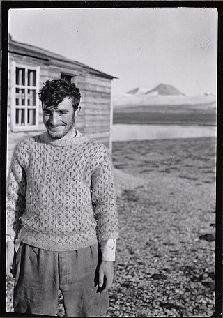
Sir Walter William Herbert was a British polar explorer, writer and artist. In 1969 he became the first man fully recognized for walking to the North Pole, on the 60th anniversary of Robert Peary's disputed expedition. He was described by Sir Ranulph Fiennes as "the greatest polar explorer of our time".

Due to climate change in the Arctic, this polar region is expected to become "profoundly different" by 2050. The speed of change is "among the highest in the world", with the rate of warming being 3-4 times faster than the global average. This warming has already resulted in the profound Arctic sea ice decline, the accelerating melting of the Greenland ice sheet and the thawing of the permafrost landscape. These ongoing transformations are expected to be irreversible for centuries or even millennia.
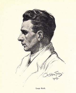
Lauge Koch was a Danish geologist and Arctic explorer.

The Extreme Ice Survey (EIS), based in Boulder, Colorado, uses time-lapse photography, conventional photography and video to document the effects of global warming on glacial ice. It is the most wide-ranging glacier study ever conducted using ground-based, real-time photography. Starting in 2007 the EIS team installed as many as 43 time-lapse cameras at a time at 18 glaciers in Greenland, Iceland, Alaska, Canada, the Nepalese Himalaya, and the Rocky Mountains of the U.S. The cameras shoot year-round, during daylight, at various rates. The team supplements the time-lapse record by occasionally repeating shots at fixed locations in Iceland, Bolivia, the Canadian province of British Columbia and the French and Swiss Alps. Collected images are being used for scientific evidence and as part of a global outreach campaign aimed at educating the public about the effects of climate change. EIS imagery has appeared in time-lapse videos displayed in the terminal at Denver International Airport; in media productions such as the 2009 NOVA Extreme Ice documentary on PBS; and is the focus of the feature-length film Chasing Ice, directed by Jeff Orlowski, which premiered at the Sundance film festival in Utah on January 23, 2012. Major findings were published in 2012 in Ice: Portraits of the World’s Vanishing Glaciers by James Balog.

The Fram Strait is the passage between Greenland and Svalbard, located roughly between 77°N and 81°N latitudes and centered on the prime meridian. The Greenland and Norwegian Seas lie south of Fram Strait, while the Nansen Basin of the Arctic Ocean lies to the north. Fram Strait is noted for being the only deep connection between the Arctic Ocean and the World Oceans. The dominant oceanographic features of the region are the West Spitsbergen Current on the east side of the strait and the East Greenland Current on the west.
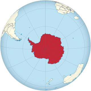
This is an alphabetical index of all articles related to the continent of Antarctica.
The Dark Snow Project is a field and lab exploration to measure the impact of changing wildfire and industrial soot and snow microbes on snow and ice reflectivity.
Jason Eric Box is an American glaciologist who is professor in glaciology at the Geological Survey of Denmark and Greenland. For 10 years (2002-2012) he worked at Byrd Polar Research Center at Ohio State University, eventually a tenured physical climatology and geography associate professor in the department of geography.

Robin Elizabeth Bell is Palisades Geophysical Institute (PGI) Lamont Research Professor at Columbia University's Lamont–Doherty Earth Observatory and a past President of the American Geophysical Union (AGU), 2019–2021. Dr. Bell was influential in co-ordinating the 2007 International Polar Year and was the first woman to chair the National Academy of Sciences Polar Research Board. She has made numerous important discoveries with regard to subglacial lakes and ice sheet dynamics, and has a ridge, called Bell Buttress, in Antarctica named after her.

Louise Tolle Huffman is an American teacher with over 30 years of teaching experience with many years focused on polar science and climate studies, and has written educational outreach books and articles on Antarctica. She is the Director of Education and Outreach for the US Ice Drilling Program Office (IDPO), responsible for outreach efforts highlighting IDPO scientists and their research results.
Walter C. Oechel is a researcher who studies the areas of plant eco-physiology, systems ecology, global change, and biosphere-atmosphere interaction. At the San Diego State University he is as a Distinguished Professor of Biology, as well as at the Open University, UK. He is also co-director of the Center for Climate and Sustainability Studies (C2S2) and the director of the Global Change Research Group at SDSU.
Kirsteen Jane Tinto is a glaciologist known for her research on the behavior and subglacial geology of the Greenland and Antarctic ice sheets.
Sarah Das is an American glaciologist and climate scientist. She works at the Woods Hole Oceanographic Institute in Woods Hole, Massachusetts.
References
- 1 2 www.polartrec.com
- ↑ "ABC News". ABC News: PolarTREC.
- ↑ "PolarTREC Expeditions".
- ↑ "Airborne Survey of Polar Ice 2013 | PolarTREC". PolarTREC Expeditions.
- ↑ "Tectonic History of the Transantarctic Mountains | PolarTREC". PolarTREC Expeditions.
- ↑ "Greenland Education Tour 2012 | PolarTREC". PolarTREC Expeditions.
- ↑ "YouTube". YouTube PolarTREC Expedition.
- ↑ "Frequently Asked Questions for Teachers | PolarTREC". www.polartrec.com. Archived from the original on 2010-10-04.
- ↑ "PolarTREC Lets Teachers Instruct from Poles". ABC News .
- ↑ "About PolarTREC | PolarTREC".