
Earth is the third planet from the Sun and the only astronomical object known to harbor life. This is enabled by Earth being a water world, the only one in the Solar System sustaining liquid surface water. Almost all of Earth's water is contained in its global ocean, covering 70.8% of Earth's crust. The remaining 29.2% of Earth's crust is land, most of which is located in the form of continental landmasses within one hemisphere, Earth's land hemisphere. Most of Earth's land is somewhat humid and covered by vegetation, while large sheets of ice at Earth's polar deserts retain more water than Earth's groundwater, lakes, rivers and atmospheric water combined. Earth's crust consists of slowly moving tectonic plates, which interact to produce mountain ranges, volcanoes, and earthquakes. Earth has a liquid outer core that generates a magnetosphere capable of deflecting most of the destructive solar winds and cosmic radiation.

Mercury is the first planet from the Sun and the smallest in the Solar System. It is a terrestrial planet with a heavily cratered surface due to overlapping impact events. These features are well preserved since the planet has no geological activity and an extremely tenuous atmosphere called an exosphere. Despite being the smallest planet in the Solar System with a mean diameter of 4,880 km (3,030 mi), 38% of that of Earth, Mercury is dense enough to have roughly the same surface gravity as Mars. Mercury has a dynamic magnetic field with a strength about 1% of that of Earth's and has no natural satellites.

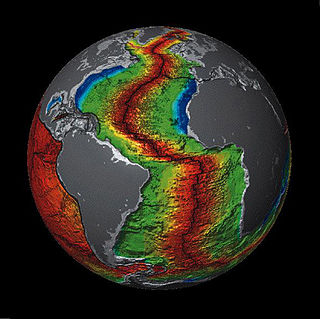
Plate tectonics is the scientific theory that Earth's lithosphere comprises a number of large tectonic plates which have been slowly moving since about 3.4 billion years ago. The model builds on the concept of continental drift, an idea developed during the first decades of the 20th century. Plate tectonics came to be accepted by geoscientists after seafloor spreading was validated in the mid-to-late 1960s.

In geology, a supercontinent is the assembly of most or all of Earth's continental blocks or cratons to form a single large landmass. However, some geologists use a different definition, "a grouping of formerly dispersed continents", which leaves room for interpretation and is easier to apply to Precambrian times. To separate supercontinents from other groupings, a limit has been proposed in which a continent must include at least about 75% of the continental crust then in existence in order to qualify as a supercontinent.
Venus is the second planet from the Sun. It is a rocky planet with the densest atmosphere of all the rocky bodies in the Solar System, and the only one with a mass and size that is close to that of its orbital neighbour Earth. Orbiting inferiorly, it appears in Earth's sky always close to the Sun, as either a "morning star" or an "evening star". While this is also true for Mercury, Venus appears much more prominently, since it is the third brightest object in Earth's sky after the Moon and the Sun, appearing brighter than any other star-like classical planet or any fixed star. With such prominence in Earth's sky, Venus has historically been a common and important object for humans, in both their cultures and astronomy.
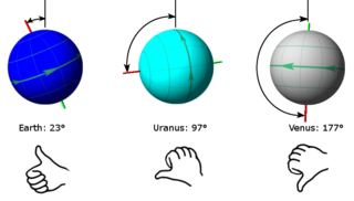
In astronomy, axial tilt, also known as obliquity, is the angle between an object's rotational axis and its orbital axis, which is the line perpendicular to its orbital plane; equivalently, it is the angle between its equatorial plane and orbital plane. It differs from orbital inclination.

Earth's magnetic field, also known as the geomagnetic field, is the magnetic field that extends from Earth's interior out into space, where it interacts with the solar wind, a stream of charged particles emanating from the Sun. The magnetic field is generated by electric currents due to the motion of convection currents of a mixture of molten iron and nickel in Earth's outer core: these convection currents are caused by heat escaping from the core, a natural process called a geodynamo.
The Chandler wobble or Chandler variation of latitude is a small deviation in the Earth's axis of rotation relative to the solid earth, which was discovered by and named after American astronomer Seth Carlo Chandler in 1891. It amounts to change of about 9 metres (30 ft) in the point at which the axis intersects the Earth's surface and has a period of 433 days. This wobble, which is an astronomical nutation, combines with another wobble with a period of one year, so that the total polar motion varies with a period of about 7 years.

In astronomy, the rotation period or spin period of a celestial object has two definitions. The first one corresponds to the sidereal rotation period, i.e., the time that the object takes to complete a full rotation around its axis relative to the background stars. The other type of commonly used "rotation period" is the object's synodic rotation period, which may differ, by a fraction of a rotation or more than one rotation, to accommodate the portion of the object's orbital period around a star or another body during one day.
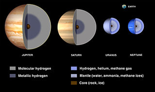
A planetary core consists of the innermost layers of a planet. Cores may be entirely solid or entirely liquid, or a mixture of solid and liquid layers as is the case in the Earth. In the Solar System, core sizes range from about 20% to 85% of a planet's radius (Mercury).
A mantle is a layer inside a planetary body bounded below by a core and above by a crust. Mantles are made of rock or ices, and are generally the largest and most massive layer of the planetary body. Mantles are characteristic of planetary bodies that have undergone differentiation by density. All terrestrial planets, a number of asteroids, and some planetary moons have mantles.

Polar motion of the Earth is the motion of the Earth's rotational axis relative to its crust. This is measured with respect to a reference frame in which the solid Earth is fixed. This variation is a few meters on the surface of the Earth.
The cataclysmic pole shift hypothesis is a pseudo-scientific claim that there have been recent, geologically rapid shifts in the axis of rotation of Earth, causing calamities such as floods and tectonic events or relatively rapid climate changes.

The supercontinent cycle is the quasi-periodic aggregation and dispersal of Earth's continental crust. There are varying opinions as to whether the amount of continental crust is increasing, decreasing, or staying about the same, but it is agreed that the Earth's crust is constantly being reconfigured. One complete supercontinent cycle is said to take 300 to 500 million years. Continental collision makes fewer and larger continents while rifting makes more and smaller continents.
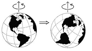
True polar wander is a solid-body rotation of a planet or moon with respect to its spin axis, causing the geographic locations of the north and south poles to change, or "wander". Unless the body is totally rigid its stable state rotation has the largest moment of inertia axis aligned with the spin axis, with the smaller two moments of inertia axes lying in the plane of the equator. If the body is not in this steady state, true polar wander will occur: the planet or moon will rotate as a rigid body to realign the largest moment of inertia axis with the spin axis.

Pangaea or Pangea was a supercontinent that existed during the late Paleozoic and early Mesozoic eras. It assembled from the earlier continental units of Gondwana, Euramerica and Siberia during the Carboniferous approximately 335 million years ago, and began to break apart about 200 million years ago, at the end of the Triassic and beginning of the Jurassic. In contrast to the present Earth and its distribution of continental mass, Pangaea was centred on the equator and surrounded by the superocean Panthalassa and the Paleo-Tethys and subsequent Tethys Oceans. Pangaea is the most recent supercontinent to have existed and the first to be reconstructed by geologists.
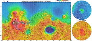
The most conspicuous feature of Mars is a sharp contrast, known as the Martian dichotomy, between the Southern and the Northern hemispheres. The two hemispheres' geography differ in elevation by 1 to 3 km. The average thickness of the Martian crust is 45 km, with 32 km in the northern lowlands region, and 58 km in the southern highlands.
Apparent polar wander (APW) is the perceived movement of the Earth's paleomagnetic poles relative to a continent while regarding the continent being studied as fixed in position. It is frequently displayed on the present latitude-longitude map as a path connecting the locations of geomagnetic poles, inferred at distinct times using paleomagnetic techniques.
Plate reconstruction is the process of reconstructing the positions of tectonic plates relative to each other or to other reference frames, such as the Earth's magnetic field or groups of hotspots, in the geological past. This helps determine the shape and make-up of ancient supercontinents and provides a basis for paleogeographic reconstructions.
Earth's crustal evolution involves the formation, destruction and renewal of the rocky outer shell at that planet's surface.

