Meiobenthos, also called meiofauna, are small benthic invertebrates that live in marine or freshwater environments, or both. The term meiofauna loosely defines a group of organisms by their size—larger than microfauna but smaller than macrofauna—rather than by their taxonomy. This fauna includes both animals that turn into macrofauna later in life, and those small enough to belong to the meiobenthos their entire life. In marine environments there can be thousands of individuals in 10 cubic centimeters of sediment, and counts animals like nematodes, copepods, rotifers, tardigrades and ostracods, but protists like ciliates and foraminifers within the size range of the meiobethos are also often included. In practice, the term usually includes organisms that can pass through a 1 mm mesh but are retained by a 45 μm mesh, though exact dimensions may vary. Whether an organism will pass through a 1 mm mesh also depends upon whether it is alive or dead at the time of sorting.

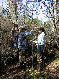
Paleoethnobotany, or archaeobotany, is the study of past human-plant interactions through the recovery and analysis of ancient plant remains. Both terms are synonymous, though paleoethnobotany is generally used in North America and acknowledges the contribution that ethnographic studies have made towards our current understanding of ancient plant exploitation practices, while the term archaeobotany is preferred in Europe and emphasizes the discipline's role within archaeology.

Palynology is the study of microorganisms and microscopic fragments of mega-organisms that are composed of acid-resistant organic material and occur in sediments, sedimentary rocks, and even some metasedimentary rocks. Palynomorphs are the microscopic, acid-resistant organic remains and debris produced by a wide variety of plants, animals, and Protista that have existed since the late Proterozoic.
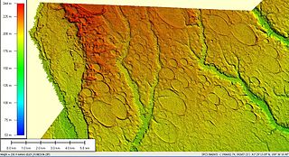
Carolina bays are elliptical to circular depressions concentrated along the East Coast of the United States within coastal New York, New Jersey, Delaware, Maryland, Virginia, North Carolina, South Carolina, Georgia, and north Florida. In Maryland, they are called Maryland basins. Within the Delmarva Peninsula, they and other coastal ponds are also called Delmarva bays.
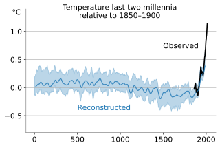
In the study of past climates ("paleoclimatology"), climate proxies are preserved physical characteristics of the past that stand in for direct meteorological measurements and enable scientists to reconstruct the climatic conditions over a longer fraction of the Earth's history. Reliable global records of climate only began in the 1880s, and proxies provide the only means for scientists to determine climatic patterns before record-keeping began.

Pollen zones are a system of subdividing the Last Glacial Period and Holocene paleoclimate using the data from pollen cores. The sequence provides a global chronological structure to a wide variety of researchers, such as geologists, climatologists, geographers and archaeologists, who study the physical and cultural environment of the last 15,000 years.

A core sample is a cylindrical section of (usually) a naturally-occurring substance. Most core samples are obtained by drilling with special drills into the substance, such as sediment or rock, with a hollow steel tube, called a core drill. The hole made for the core sample is called the "core hole". A variety of core samplers exist to sample different media under different conditions; there is continuing development in the technology. In the coring process, the sample is pushed more or less intact into the tube. Removed from the tube in the laboratory, it is inspected and analyzed by different techniques and equipment depending on the type of data desired.

Tephrochronology is a geochronological technique that uses discrete layers of tephra—volcanic ash from a single eruption—to create a chronological framework in which paleoenvironmental or archaeological records can be placed. Such an established event provides a "tephra horizon". The premise of the technique is that each volcanic event produces ash with a unique chemical "fingerprint" that allows the deposit to be identified across the area affected by fallout. Thus, once the volcanic event has been independently dated, the tephra horizon will act as time marker. It is a variant of the basic geological technique of stratigraphy.

Paleolimnology is a scientific sub-discipline closely related to both limnology and paleoecology. Paleolimnological studies focus on reconstructing the past environments of inland waters using the geologic record, especially with regard to events such as climatic change, eutrophication, acidification, and internal ontogenic processes.

Geotechnical investigations are performed by geotechnical engineers or engineering geologists to obtain information on the physical properties of soil earthworks and foundations for proposed structures and for repair of distress to earthworks and structures caused by subsurface conditions; this type of investigation is called a site investigation. Geotechnical investigations are also used to measure the thermal resistance of soils or backfill materials required for underground transmission lines, oil and gas pipelines, radioactive waste disposal, and solar thermal storage facilities. A geotechnical investigation will include surface exploration and subsurface exploration of a site. Sometimes, geophysical methods are used to obtain data about sites. Subsurface exploration usually involves soil sampling and laboratory tests of the soil samples retrieved.
The box corer is a marine geological sampling tool for soft sediments in lakes or oceans. It is deployed from a research vessel with a wire and suitable for any water depth. It is designed for a minimum of disturbance of the sediment surface by bow wave effects which is important for quantitative investigations of the benthic micro- to macrofauna, geochemical processes, sampling of bottom water or sedimentology.
Environmental monitoring is the processes and activities that are done to characterize and describe the state of the environment. It is used in the preparation of environmental impact assessments, and in many circumstances in which human activities may cause harmful effects on the natural environment. Monitoring strategies and programs are generally designed to establish the current status of an environment or to establish a baseline and trends in environmental parameters. The results of monitoring are usually reviewed, analyzed statistically, and published. A monitoring program is designed around the intended use of the data before monitoring starts.
ABISMO is a remotely operated underwater vehicle (ROV) built by the Japan Agency for Marine-Earth Science and Technology (JAMSTEC) for exploration of the deep sea. It is the only remaining ROV rated to 11,000-meters, ABISMO is intended to be the permanent replacement for Kaikō, a ROV that was lost at sea in 2003.
Margaret Bryan Davis (néeMargaret Bryan; was an American palynologist and paleoecologist, who used pollen data to study the vegetation history of the past 21,000 years. She showed conclusively that temperate- and boreal-forest species migrated at different rates and in different directions while forming a changing mosaic of communities. Early in her career, she challenged the standard methods and prevailing interpretations of the data and fostered rigorous analysis in palynology. As a leading figure in ecology and paleoecology, she served as president of the Ecological Society of America and the American Quaternary Association and as chair of the Department of Ecology, Evolution and Behavior at the University of Minnesota. In 1982 she was elected to the National Academy of Sciences and, in 1993, received the Eminent Ecologist Award from the Ecological Society of America.

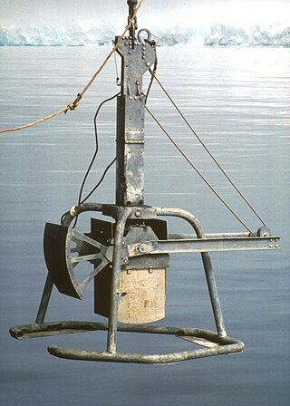
The Van Veen grab sampler is an instrument to sample sediment in water environments. Usually it is a clamshell bucket made of stainless steel. Up to 20 cm deep samples of roughly 0.1 m2 can be extracted with this instrument. It can be light-weight and low-tech. The smallest version even fits into hand luggage. The sampler was invented by Johan van Veen in 1933.

Postglacial vegetation refers to plants that colonize the newly exposed substrate after a glacial retreat. The term "postglacial" typically refers to processes and events that occur after the departure of glacial ice or glacial climates.
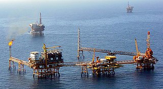
Offshore geotechnical engineering is a sub-field of geotechnical engineering. It is concerned with foundation design, construction, maintenance and decommissioning for human-made structures in the sea. Oil platforms, artificial islands and submarine pipelines are examples of such structures. The seabed has to be able to withstand the weight of these structures and the applied loads. Geohazards must also be taken into account. The need for offshore developments stems from a gradual depletion of hydrocarbon reserves onshore or near the coastlines, as new fields are being developed at greater distances offshore and in deeper water, with a corresponding adaptation of the offshore site investigations. Today, there are more than 7,000 offshore platforms operating at a water depth up to and exceeding 2000 m. A typical field development extends over tens of square kilometers, and may comprise several fixed structures, infield flowlines with an export pipeline either to the shoreline or connected to a regional trunkline.

The Young grab, or the Young modified Van Veen grab sampler is an instrument to sample sediment in the ocean. It is a modified version of the Van Veen grab sampler, with a clamshell bucket made out of stainless steel mounted to a supporting frame. The sampling area extracted with this instrument can vary depending on its size. With the modifications this version of the Van Veen grab sampler is heavier than the traditional version. The frame allows for better stability and level sampling. Weights can be attached to the frame to ensure the bucket grabs sufficient sediment, or skids to ensure the gear does not sink too deep in soft sediments.
This page is a glossary of archaeology, the study of the human past from material remains.
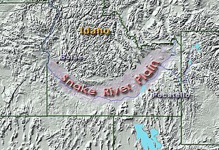
The paleo-climate of the Snake River Plain in southern Idaho, U.S., was much wetter and milder than today’s climate. During the Pliocene, the presence of a large lake provided habitat for fish. As the climate started to dry during the Pleistocene, vegetation similar to the present-day flora developed, although its geographical distribution was markedly different. Further drying occurred during the North American glaciation period that followed, resulting in the general aridity of the region today.