Nitshill is a district on the south side of Glasgow. It is bordered by South Nitshill to the south, Darnley to the east, Crookston and Roughmussel to the north-west, Hurlet to the west and Househillwood and Priesthill to the north, with the Pollok district and the Silverburn Centre beyond. An area of open ground to the south-west of Nitshill forms the boundary between Glasgow and the town of Barrhead in East Renfrewshire.

Newton Mearns is a suburban town and the largest settlement in East Renfrewshire, Scotland. It lies 7 miles (11 km) southwest of Glasgow City Centre on the main road to Ayrshire, 410 feet (125 m) above sea level. It has a population of approximately 26,993, stretching from Whitecraigs and Kirkhill in the northeast to Maidenhill in the southeast, to Westacres and Greenlaw in the west and Capelrig/Patterton in the northwest.

Ruchazie is a neighbourhood in the Scottish city of Glasgow. It is situated to the north-east of the city, bordered by Craigend and Garthamlock to the east and the open ground of Hogganfield Park and Lethamhill Golf Course to the north. Ruchazie is separated from Cranhill to the south and Riddrie to the west by the M8 motorway, previously the route of the Monkland Canal.

Joan Blaeu, also called Johannes Blaeu, was a Dutch cartographer born in Alkmaar, the son of cartographer Willem Blaeu.

Dunskey Castle is a ruined, 12th-century tower house or castle, located 0.5 miles (0.80 km) south of the village of Portpatrick, Rhinns, Wigtownshire, on the south-west coast of Scotland.

Duloch, or Duloch Park, is a residential suburb of Dunfermline, in Fife, Scotland.

Glen Village is a settlement in the Falkirk council area of Scotland, situated at the southern end of Callendar Park, and around 1 mile (1.6 km) south of Falkirk town centre. It adjoins the housing estate of Hallglen, with the two localities counted together in most official statistics.

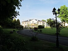
Castle Semple is a former mansion house located in Renfrewshire, Scotland. It is situated near the eastern end of Castle Semple Loch, within Clyde Muirshiel Regional Park.

Pittarthie Castle is the remains of what was a laird’s tower house in Fife, Scotland dating to the end of the sixteenth century. The ruins of the structure are located 2.5 kilometres (1.6 mi) southwest of Dunino, and 6.5 kilometres (4.0 mi) northwest of Anstruther. The name is spelled Pittarthie and Pittairthie in extant records. The ruins are protected as a scheduled monument.

Longriggend is a village in North Lanarkshire, Scotland, with a population of approximately 200.

The Altes Schloss Bümpliz is a castle in the section of Bümpliz-Oberbottigen in the city of Bern of the canton of Bern in Switzerland.
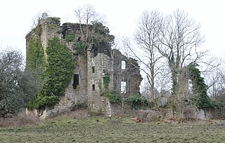
The substantial remains of the old castle and sixteenth century manor house of Kilbirnie lie west of the town of Kilbirnie in North Ayrshire, Scotland, on the lower slopes of the Glengarnock Hills, in the old Barony of Kilbirnie. The building is also variously known as the Place of Kilbirnie, The Place, or Kilbirnie House.
Cardonald Place Farm is a farmhouse on the banks of the White Cart Water river in Cardonald, Glasgow, Scotland. It was built in 1848 on the site occupied by the former Cardonald Palace.

The site of the old Lefnoreis Castle or Ward of Lochnorris lies about 100 yards north-west of the old stable block of Dumfries House in East Ayrshire, Parish of Old Cumnock, Scotland. The old castle stood on a natural rise overlooking the Lugar Water, built and held for many years by the Craufurd family. For consistency the spelling Craufurd will be used throughout and Lefnoreis for the castle.
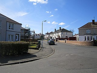
Househillwood is a residential neighbourhood of Glasgow, Scotland, situated in the south-west of the city.

Rosshall is an area in the south-west of Glasgow, Scotland, within the Cardonald ward of Glasgow City Council. It has a fairly isolated location, with the White Cart Water forming a border to the south and east, the Paisley Canal Line railway to the north, and open fields to the west that form a short green belt between Glasgow and the large town of Paisley – the nearest building 500 yards (460 m) to the west, Rosshall Mains Farm, falls under Paisley administration rather than Glasgow.

The site of the old Newbie Castle, Newbay Castle or Newby Castle was the caput of the Barony of Newbie near Annan close to the confluence of the River Annan and the Solway Firth in Dumfries and Galloway, Scotland. Held by the Corries and then the Johnstones. Newbie Harbour on the River Annan was located nearby.
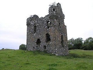
Plunton Castle is a ruined L-plan tower house between Kirkandrews and Gatehouse of Fleet in Dumfries and Galloway, Scotland. Built around 1575 for the Lennoxes of Plunton, it passed by marriage to the Murrays of Broughton in the late 17th century. It was still inhabited in 1684, when it was described by Reverend Symson in his Large Description of Galloway as "a good strong house", but by 1838, when it was painted by George Colomb, it had been abandoned and had fallen into a ruinous condition.
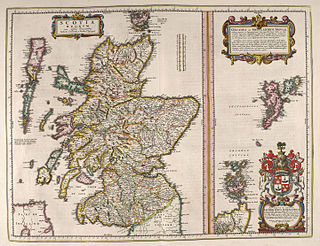
The book commonly known as Blaeu Atlas of Scotland, the fifth volume of Theatrum Orbis Terrarum Sive Atlas Novus, is the first known atlas of Scotland and Ireland. It was compiled by Joan Blaeu, and contains 49 engraved maps and 154 pages of descriptive text written in Latin; it was first published in 1654. Most of the maps were made by Timothy Pont, a Scottish cartographer. Those maps, made between 1583 and 1596, were collected, edited, and augmented with other maps by John Scot, Lord Scotstarvit, a Scottish laird.

The Castle and Lands of Auchruglen (NS5365436797) was a peel tower in the old district of Kyle held at different times by the Nesbitt and Campbell Clans and located near Newmilns, Parish of Galston, East Ayrshire, Scotland.