Related Research Articles

A lightvessel, or lightship, is a ship that acts as a lighthouse. They are used in waters that are too deep or otherwise unsuitable for lighthouse construction. Although some records exist of fire beacons being placed on ships in Roman times, the first modern lightvessel was off the Nore sandbank at the mouth of the River Thames in England, placed there by its inventor Robert Hamblin in 1734. The type has become largely obsolete; lighthouses replaced some stations as the construction techniques for lighthouses advanced, while large, automated buoys replaced others.

The Nore is a long bank of sand and silt running along the south-centre of the final narrowing of the Thames Estuary, England. Its south-west is the very narrow Nore Sand. Just short of the Nore's easternmost point where it fades into the channels it has a notable point once marked by a lightship on the line where the estuary of the Thames nominally becomes the North Sea. A lit buoy today stands on this often map-marked divisor: between Havengore Creek in east Essex and Warden Point on the Isle of Sheppey in Kent.
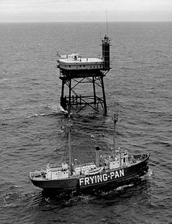
The Frying Pan Shoals are a long, shifting area of shoals off Cape Fear in North Carolina, United States. The shoals have been a hazard to ships in the area since the beginning of European exploration of the area; the area is littered with shipwrecks. The southern edge of the shoals has been marked by a lightship, a light tower and a buoy.
The station named Nantucket or Nantucket Shoals was served by a number of lightvessels that marked the hazardous Nantucket Shoals south of Nantucket Island. The vessels, given numbers as their "name," had the station name painted on their hulls when assigned to the station. Several ships have been assigned to the Nantucket Shoals lightship station and have been called Nantucket. It was common for a lightship to be reassigned and then have the new station name painted on the hull. The Nantucket station was a significant US lightship station for transatlantic voyages. Established in 1854, the station marked the limits of the dangerous Nantucket Shoals. She was the last lightship seen by vessels departing the United States, as well as the first beacon seen on approach. The position was 40 miles (64 km) southeast of Nantucket Island, the farthest lightship in North America, and experienced clockwise rotary tidal currents.
The United States lightship Huron (LV-103) is a lightvessel that was launched in 1920. She is now a museum ship moored in Pine Grove Park, Port Huron, St. Clair County, Michigan.
Ambrose Light, often called Ambrose Tower, was the light station at the convergence of several major shipping lanes in Lower New York Bay, including Ambrose Channel, the primary passage for ships entering and departing the Port of New York and New Jersey.

Stratford Shoal Light, officially Stratford Shoal Light, is a lighthouse on a shoal in the middle of Long Island Sound approximately halfway between Port Jefferson, New York and Bridgeport, Connecticut.
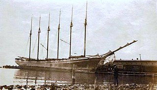
Wyoming was a wooden six-masted schooner built and completed in 1909 by the firm of Percy & Small in Bath, Maine. With a length of 450 ft (140 m) from jib-boom tip to spanker boom tip, Wyoming was the largest known wooden ship ever built.

Perdido Pass, separating Alabama Point from Florida Point, is the mouth of the Perdido River. Perdido Pass forms a water passage that connects Perdido Bay with the Gulf of Mexico to the south, in the U.S. state of Alabama, 2 miles (3 km) west of the Alabama/Florida state line. A bridge spans Perdido Pass, connecting Alabama Point with Florida Point in Alabama. At the entrance into the Gulf, the 2 rock barriers, extending from the white beaches, are the west jetty & east jetty. The surrounding area is heavily developed, with high-rise condominiums. However, there are nearby beach-front parks, with Gulf State Park on the eastern side of Perdido Pass.
USLHT Azalea was an American lighthouse tender that operated in the fleet of the United States Lighthouse Board from 1891 to 1910 and of the United States Lighthouse Service from 1910 to 1917 and from 1919 to 1933. During and in the immediate aftermath of World War I, she served in the United States Navy as USS Azalea from 1917 to 1919. During World War II, she became the U.S. Navy seaplane tender USS Christiana (YAG-32) in 1942.

Lightship No. 114, later U.S. Coast Guard WAL 536, that served as lightship Fire Island (NY), Examination Vessel, Diamond Shoal (NC), 1st District relief vessel, Pollock Rip (MA) and Portland (ME). After decommissioning in 1971, in 1975 the lightship became a historic ship at the State Pier in New Bedford, Massachusetts. She received little maintenance, and eventually sank at her moorings in 2006 and was sold for scrap the next year.
The Black Deep is in the outer Thames Estuary. It is the greatest of three mainly natural shipping channels linking the Tideway to central zones of the North Sea without shoals, the others being the Barrow Deep and Princes Channel. Between these, a few others, and the shores of Kent, Suffolk and Essex are many long shoals in the North Sea, broadly shallow enough to wreck vessels of substantial draft at low tide.
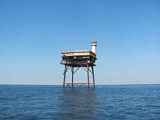
Diamond Shoal Light is an inactive offshore lighthouse marking Diamond Shoals off Cape Hatteras.

The February 1952 nor'easter was a significant winter storm that impacted the New England region of the United States. The storm ranked as Category 1, or "notable", on the Northeast Snowfall Impact Scale. Its rapid intensification resulted in heavy snowfall between February 17 and 18, accumulating to 12 to 30 inches. High winds also affected central and northern New England. The nor'easter is estimated to have caused 42 fatalities. In Maine, over 1,000 travelers became stranded on roadways. Two ships cracked in two offshore New England during the storm.

Diamond Shoal Lightship No. 71 (LV-71) was a lightship of the United States Lighthouse Service. She is most remembered for her sinking in 1918 during World War I when a German U-boat attacked her off North Carolina. Her shipwrecked remains were listed on the National Register of Historic Places in 2015.

The Carr is a sandstone reef on the headland between the Firth of Forth and St Andrews Bay. There have been many ships wrecked on the reef, which lies on the busy shipping lanes into the Forth ports and the River Tay.
The Kentish Knock is a long shoal in the North Sea east of Essex, England. It is the most easterly of those of the Thames Estuary and its core, which is shallower than 18 feet (5.5 m), extends 6 miles (9.7 km). Thus it is a major hazard to deep-draught navigation. It is exactly 28 miles (45 km) due east of Foulness Point, Essex and is centred about 15 miles (24 km) NNE of North Foreland, Kent – both are extreme points of those counties.
Five Fathom Bank light station was a station for lightvessels in New Jersey, United States. It was located off the south end of Five Fathom Bank, 14.7 miles and 100 degrees from the Cape May Lighthouse. The station was in service from 1837 to 1972 before ultimately being replaced by a horn buoy.

SS Pendleton was a Type T2-SE-A1 tanker built in 1944 in Portland, Oregon, United States, for the War Shipping Administration. She was sold in 1948 to National Bulk Carriers, serving until February 1952 when she broke in two in a storm. The T2 tanker ships were prone to splitting in two in cold weather. The ship's sinking and crew rescue is the topic of the 2009 book The Finest Hours: The True Story Behind the US Coast Guard's Most Daring Rescue, by Michael J. Tougias. Tougias' book inspired the 2016 Disney-produced film The Finest Hours with Chris Pine, which focuses on the Pendleton rescue.
A number of vessels served as the Pollock Rip Lightship first located to mark the junction of Pollock Rip and Pollock Rip Slue channels. The area was heavily used and subject to heavy fog. The station itself changed within the locality. From 1889 to 1913 the red hull was marked in white with Pollock Rip and then simply Pollock from 1913 to 1969. A nearby station, occupied from 1902 to 1923 by Lightship No. 73 before it was assigned to Pollock Rip station in 1923, was marked Pollock Rip Slue. The station was not occupied between February 16 and October 16, 1924 and was replaced by a buoy 1942 — 1945.
References
- 1 2 3 4 5 "Pollock Rip Shoals". Missions. U.S. Army Corps of Engineers, New England District. Retrieved 30 September 2014.
![]() This article incorporates public domain material from the United States Army document: "Pollock Rip Shoals Navigation Project" . Retrieved 2015-08-25.
This article incorporates public domain material from the United States Army document: "Pollock Rip Shoals Navigation Project" . Retrieved 2015-08-25.