Related Research Articles

The A30 is a major road in England, running 284 miles (457 km) WSW from London to Land's End.

The Battle of Brunanburh was fought in 937 between Æthelstan, King of England, and an alliance of Olaf Guthfrithson, King of Dublin, Constantine II, King of Scotland, and Owain, King of Strathclyde. The battle is often cited as the point of origin for English nationalism: historians such as Michael Livingston argue that "the men who fought and died on that field forged a political map of the future that remains [in modernity], arguably making the Battle of Brunanburh one of the most significant battles in the long history not just of England, but of the whole of the British Isles."

The Fosse Way was a Roman road built in Britain during the first and second centuries AD that linked Isca Dumnoniorum (Exeter) in the southwest and Lindum Colonia (Lincoln) to the northeast, via Lindinis (Ilchester), Aquae Sulis (Bath), Corinium (Cirencester), and Ratae Corieltauvorum (Leicester).

East Devon is a local government district in Devon, England. Its council has been based in Honiton since February 2019, and the largest town is Exmouth.
Honiton is a market town and civil parish in East Devon, situated close to the River Otter, 17 miles (27 km) north east of Exeter in the county of Devon. Honiton has a population estimated at 11,822.

The A35 is a major road in southern England, connecting Honiton in Devon and Southampton in Hampshire. It is a trunk road for some of its length. Most of its route passes through Dorset and the New Forest. It originally connected Exeter and Southampton, the original A35 ran along what is now the A3052 joining the present road at Charmouth.

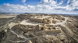
Avdat, also known as Abdah and Ovdat and Obodat, is a site of a ruined Nabataean city in the Negev desert in southern Israel. It was the most important city on the Incense Route after Petra, between the 1st century BCE and the 7th century CE. It was founded in the 3rd century BCE, and inhabited by Nabataeans, Romans, Byzantines, and during the early Islamic period. Avdat was a seasonal camping ground for Nabataean caravans travelling along the early Petra–Gaza road in the 3rd – late 2nd century BCE. The city's original name was changed to Avdat in honor of Nabataean King Obodas I, who, according to tradition, was revered as a deity and was buried there.

The Blackdown Hills are a range of hills along the Somerset-Devon border in south-western England, which were designated an Area of Outstanding Natural Beauty (AONB) in 1991.
Alchester is the site of an ancient Roman town. The site is not included in any ancient references so the Roman name is not known. However, Eilert Ekwall contended that it appears as Alavna in the Ravenna Cosmography, with the addition of the Old English ceaster to signify a Roman fort. It lies about 2 miles (3 km) south of Bicester, in the northwest corner of the civil parish of Wendlebury in the English county of Oxfordshire.

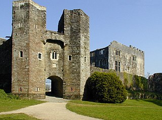
Berry Pomeroy Castle, a Tudor mansion within the walls of an earlier castle, is near the village of Berry Pomeroy, in South Devon, England. It was built in the late 15th century by the Pomeroy family which had held the land since the 11th century. By 1547 the family was in financial difficulties and sold the lands to Edward Seymour, 1st Duke of Somerset. Apart from a short period of forfeit to the Crown after Edward's execution, the castle has remained in the Seymour family ever since, although it was abandoned in the late 17th century when the fourth baronet moved to Wiltshire.

Exmouth Junction is the railway junction where the Exmouth branch line diverges from the London Waterloo to Exeter main line in Exeter, Devon, England. It was for many years the location for one of the largest engine sheds in the former London and South Western Railway. The sidings served the railway's concrete casting factory as well as a goods yard.

Fairmile is a hamlet in the English county of Devon. In the late 1990s, Fairmile became a focus of direct action protest activities, as squatters attempted to stop the construction of the A30 link road between Honiton and Exeter.

Castleshaw Roman fort was a castellum in the Roman province of Britannia. Although there is no evidence to substantiate the claim, it has been suggested that Castleshaw Roman fort is the site of Rigodunum, a Brigantian settlement. The remains of the fort are located on Castle Hill on the eastern side of Castleshaw Valley at the foot of Standedge but overlooking the valley. The hill is on the edge of Castleshaw in Greater Manchester. The fort was constructed in c. AD 79, but fell out of use at some time during the 90s. It was replaced by a smaller fortlet, built in c. 105, around which a civilian settlement grew. It may have served as a logistical and administrative centre, although it was abandoned in the 120s.

Raddon Top is the highest point of the Raddon Hills, a small ridge of hills in the Shobrooke area of Mid Devon. The summit is at some 235 metres above sea level, making it a significant feature in the surrounding countryside.

The Chichester to Silchester Way is a Roman Road between Chichester in South-East England, which as Noviomagus was capital of the Regni, and Silchester or Calleva Atrebatum, capital of the Atrebates. The road had been entirely lost and forgotten, leaving no Saxon place names as clues to its existence, until its chance discovery through aerial photography in 1949. Only 6 kilometres (3.7 mi) of the 62 kilometres (39 mi) long road remain in use.

Clausentum was a small town in the Roman province of Britannia. The site is believed to be located in Bitterne Manor, which is now a suburb of Southampton.

Clyst Honiton is an English village and civil parish five miles from Exeter in the East Devon district, in the county of Devon. The church is St Michael and All Angels. Exeter International Airport which opened in 1938 is located on the outskirts of the village. The village was originally on the main A30 road from Exeter to Honiton but was bypassed in the 1990s. Another bypass to the east of the village linking the A30 to the new developments around Cranbrook opened in October 2013.

Gittisham is a village and civil parish in Devon near Honiton. The village is 3 miles (5 km) from Ottery St Mary and it has a church called St Michael. The parish is surrounded, clockwise from the north, by the parishes of Awliscombe, Honiton, Sidmouth, Ottery St Mary, Feniton and Buckerell.

The Orange Way, so called because it follows the march in 1688 of Prince William of Orange and his army from Brixham to London, is a 350 miles (560 km) unofficial long-distance walk in England that passes through Devon, Dorset, Wiltshire, Berkshire, Buckinghamshire and London.

Honiton Town Football Club is a football club based in Honiton, Devon, England. They are currently members of the South West Peninsula League Premier Division East and play at Mountbatten Park.
References
- ↑ "A30 Honiton to Exeter - Horse Power - Roman Style". Roads to the Past: Trunk Roads and Archaeology - 1999 report. Highways Agency. 1999. Archived from the original on 5 June 2009. Retrieved 17 October 2009.
Coordinates: 50°47′13″N3°13′59″W / 50.787°N 3.233°W