
Zhenbao Island or Damansky Island is a small island measuring 0.74 square kilometres (0.29 sq mi). It is located on the Ussuri River on the border between Primorsky Krai of Russia and Heilongjiang province, People's Republic of China (PRC).

Trusnov is a village in the Pardubice Region of the Czech Republic. It has around 220 inhabitants.
Ostřetín is a village in the Pardubice Region of the Czech Republic. It has around 950 inhabitants.
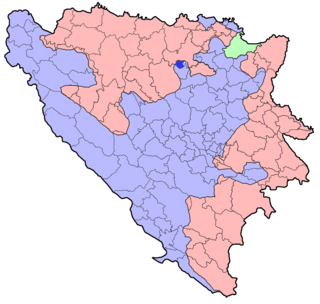
Usora is a village and municipality located in Zenica-Doboj Canton of the Federation of Bosnia and Herzegovina, an entity of Bosnia and Herzegovina. It borders with Doboj and Tešanj municipality, and it is named after the Usora River.
The Winnicut River is a 9.1-mile (14.6 km) long river in the Seacoast region of New Hampshire in the United States. It is the major southeastern tributary of Great Bay, an estuary connected by way of the tidal Piscataqua River to the Atlantic Ocean.

Hoeryong Station is a metro station on Seoul Subway Line 1. In July 2012 it became a transfer station to the U Line. It lies in the city of Uijeongbu.

Będkowo is a village in the administrative district of Gmina Trzebnica, within Trzebnica County, Lower Silesian Voivodeship, in south-western Poland. Prior to 1945 it was in Germany.

Shaghik is a village in the Shirak Province of Armenia.
Rożniatów-Kolonia is a village in the administrative district of Gmina Uniejów, within Poddębice County, Łódź Voivodeship, in central Poland. It lies approximately 10 kilometres (6 mi) north of Uniejów, 19 km (12 mi) north-west of Poddębice, and 53 km (33 mi) north-west of the regional capital Łódź.
Bobrówka is a village in the administrative district of Gmina Laszki, within Jarosław County, Subcarpathian Voivodeship, in south-eastern Poland. It lies approximately 4 kilometres (2 mi) north-west of Laszki, 14 km (9 mi) east of Jarosław, and 62 km (39 mi) east of the regional capital Rzeszów.
Piła is a village in the administrative district of Gmina Sędziszów, within Jędrzejów County, Świętokrzyskie Voivodeship, in south-central Poland. It lies approximately 5 kilometres (3 mi) south of Sędziszów, 21 km (13 mi) south-west of Jędrzejów, and 55 km (34 mi) south-west of the regional capital Kielce.
Nagórzanki is a village in the administrative district of Gmina Kazimierza Wielka, within Kazimierza County, Świętokrzyskie Voivodeship, in south-central Poland. It lies approximately 6 kilometres (4 mi) south of Kazimierza Wielka and 74 km (46 mi) south of the regional capital Kielce.
Brzóstowa is a village in the administrative district of Gmina Ćmielów, within Ostrowiec County, Świętokrzyskie Voivodeship, in south-central Poland. It lies approximately 3 kilometres (2 mi) west of Ćmielów, 8 km (5 mi) south-east of Ostrowiec Świętokrzyski, and 62 km (39 mi) east of the regional capital Kielce.
Bogucice Pierwsze is a village in the administrative district of Gmina Pińczów, within Pińczów County, Świętokrzyskie Voivodeship, in south-central Poland. It lies approximately 7 kilometres (4 mi) south-east of Pińczów and 45 km (28 mi) south of the regional capital Kielce.
Pinka is a village in the administrative district of Gmina Dolsk, within Śrem County, Greater Poland Voivodeship, in west-central Poland. It lies approximately 5 kilometres (3 mi) north of Dolsk, 8 km (5 mi) south of Śrem, and 44 km (27 mi) south of the regional capital Poznań.
Klewno is a settlement in Gmina Miastko, Bytów County, Pomeranian Voivodeship, in northern Poland. It lies approximately 30 kilometres (19 mi) south-west of Bytów and 109 km (68 mi) south-west of Gdańsk.
Lądek is a village in the administrative district of Gmina Bisztynek, within Bartoszyce County, Warmian-Masurian Voivodeship, in northern Poland. It lies approximately 5 kilometres (3 mi) south-west of Bisztynek, 23 km (14 mi) south of Bartoszyce, and 38 km (24 mi) north-east of the regional capital Olsztyn.
Powidz is a village in the administrative district of Gmina Polanów, within Koszalin County, West Pomeranian Voivodeship, in north-western Poland. It lies approximately 17 kilometres (11 mi) north-west of Polanów, 20 km (12 mi) east of Koszalin, and 152 km (94 mi) north-east of the regional capital Szczecin.
The Hohe Warte is a hill in Bavaria, Germany.
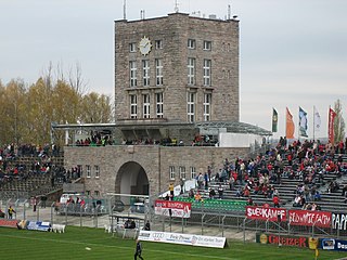
Westsachsenstadion is a multi-use stadium in Zwickau, Germany. Prior to being redeveloped in 2013 it was used mostly for football matches and served as the home stadium of FSV Zwickau until 2010. The stadium holds 5,000 people.


