
The Battle of Tarakan was the first stage in the Borneo campaign of 1945. It began with an amphibious landing by Allied forces on 1 May, code-named Operation Oboe One; the Allied ground forces were drawn mainly from the Australian 26th Brigade, but included a small element of Netherlands East Indies personnel. The main objective of the landing was the capture of the island's airfield. While the battle ended with success for the Allied forces over the Japanese defenders, this victory is generally regarded as having not justified its costs. The airfield was so heavily damaged that it ultimately could not be repaired in time to make it operational for other phases of the Allied campaign in Borneo.

The 3rd Ranger Battalion is the third of three Ranger Battalions belonging to the United States Army's 75th Ranger Regiment. It is currently based at Fort Moore, Georgia.

Okeechobee County Airport is a general aviation airport located 3 mi (4.82 km) northwest of Okeechobee, in Okeechobee County, Florida.

Marston Mat, more properly called pierced (or perforated) steel planking (PSP), is standardized, perforated steel matting material developed by the United States at the Waterways Experiment Station shortly before World War II, primarily for the rapid construction of temporary runways and landing strips (also misspelled as Marsden matting). The nickname came from Marston, North Carolina, adjacent to Camp Mackall airfield where the material was first used.
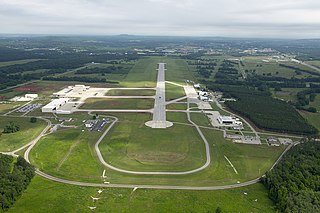
Redstone Army Airfield or Redstone AAF is a military airport located at Redstone Arsenal, six miles southwest of the city of Huntsville in Madison County, Alabama, United States. The airfield was originally constructed for munitions testing for the U.S. Army and the U.S. Army Air Forces through the 6th AAF Base Unit. It is currently used to support the U.S. Army Aviation and Missile Command, NASA, and other U.S. government aviation and space activities.

Tejgaon Airport is a Bangladesh Air Force military base in Dhaka, Bangladesh. The name of the base is BAF Base Bashar. Bangladesh Army also uses this military base. It served as the country's sole international airport prior to the construction of Hazrat Shahjalal International Airport.
Sengundram, known in English as Red Hills, is a suburb in the northwestern part of Chennai, Tamil Nadu, India in Thiruvallur District. The name was derived from the red hills that was formerly present in the area.
Naval Outlying Landing Field (NOLF) Imperial Beach is a United States Navy facility for helicopters, situated on 1,204 acres (5 km2) approximately 14 miles (23 km) south of San Diego and within the city limits of Imperial Beach, California. It is known as "The Helicopter Capital of the World".

Royal Air Force Lymington or more simply RAF Lymington is a former Royal Air Force Advanced Landing Ground in Hampshire, England. The airfield is located approximately 1 mile (1.6 km) east of Lymington; about 80 miles (130 km) southwest of London.

The Battle of Morotai, part of the Pacific War, began on 15 September 1944, and continued until the end of the war in August 1945. The fighting started when United States and Australian forces landed on the southwest corner of Morotai, a small island in the Netherlands East Indies (NEI), which the Allies needed as a base to support the liberation of the Philippines later that year. The invading forces greatly outnumbered the island's Japanese defenders and secured their objectives in two weeks. Japanese reinforcements landed on the island between September and November, but lacked the supplies needed to effectively attack the Allied defensive perimeter. Intermittent fighting continued until the end of the war, with the Japanese troops suffering heavy loss of life from disease and starvation.
During World War II, the United States Army Air Forces (USAAF) established numerous airfields in California for training pilots and aircrews of USAAF fighters and bombers.
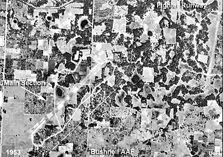
Bushnell Army Airfield is a former World War II United States Army Air Forces airfield located northeast of the intersection of Route 301 & Walker Avenue, one mile northeast of the town of Bushnell, Florida.
During World War II, Alaska was a major United States Army Air Forces (USAAF) location for personnel, aircraft, and airfields to support Lend-Lease aid for the Soviet Union. In addition, it was in Alaska that the Empire of Japan bombed and seized United States soil and as a result the USAAF was actively engaged in combat operations against them.
Fukche Advanced Landing Ground is an airfield in the Demchok sector of the union territory of Ladakh, India. It was built shortly before the 1962 Sino-Indian War and was revived in 2008. It is located adjacent to Koyul, 34 km northwest of Demchok.
Nouvion Airfield was a pre-war airport and World War II military airfield in Algeria, located about 5 km west of Camp Militaire d' El Ghomri in Mascara province; about 76 km east of Oran.

Naval Outlying Landing Field Choctaw is the United States Navy's designation for an auxiliary airfield that was originally constructed during World War II as Eglin Field Auxiliary Field # 10. It is located 16.6 miles northeast of Pensacola, Florida.

Alliance Auxiliary Army Airfield is a closed military airfield. It was located 14 miles southeast of Marianna, Florida.

Withlacoochee Army Airfield and Withlacoochee Bombing & Gunnery Range, was a World War II United States Army Air Forces airfield, located 8.2 miles (13.2 km) east of Lacoochee, Florida. The airfield closed in 1945 and is now abandoned.
Amarda Road Airstrip, also known as Rasgovindpur Airstrip is a former wartime airfield located near Rasgovindpur village in Mayurbhanj district of Odisha, India. It was used by the Royal Indian Air Force during World War II.

California during World War II was a major contributor to the World War II effort. California's long Pacific Ocean coastline provided the support needed for the Pacific War. California also supported the war in Europe. After the Japanese attack on Pearl Harbor on December 7, 1941, most of California's manufacturing was shifted to the war effort. California became a major ship builder and aircraft manufacturer. Existing military installations were enlarged and many new ones were built. California trained many of the troops before their oversea deployment. Over 800,000 Californians served in the United States Armed Forces. California agriculture, ranches and farms were used to feed the troops around the world. California's long coastline also put the state in fear, as an attack on California seemed likely. California was used for the temporary and permanent internment camps for Japanese Americans. The population grew significantly, largely due to servicemen who were stationed at the new military bases/training facilities and the mass influx of workers from around the U.S. in the growing defense industries. With all the new economy activity, California was lifted out of the Great Depression. Over 500,000 people moved to California from other states to work in the growing economy. California expanded its oil and mineral production to keep up with the war demand.
