
West End Lane is a street in inner north-west London, England that runs for about one mile between Kilburn High Road to the south and Finchley Road to the north. Located in the London Borough of Camden, and the NW6 postal district, the street winds through West Hampstead with a mix of residential and commercial buildings. The three West Hampstead stations are all located on the road at the centre of the district of that name. In the north-east it today becomes Frognal Lane, although this stretch was once included as part of West End Lane. It also marks the western boundary of South Hampstead. It is not connected to the West End of Central London, which is around three miles to the south-east.

Belsize Park Gardens is a street in the Belsize Park area of Hampstead in London. Located in the London Borough of Camden, it is residential street featuring white stucco Victorian era buildings. It runs roughly southeastwards from Belsize Avenue in Belsize Village before terminating at a junction with Eton Avenue, England's Lane and Primrose Hill Road. The Grade II listed pub The Washington, dating from around 1865, is located at its eastern end.
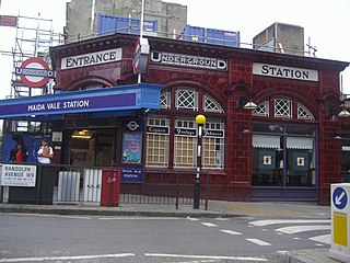
Randolph Avenue is a street in Maida Vale in London. Located in the City of Westminster, it is a long avenue running from north to south. The southern end is located in Little Venice near to the Paddington branch of the Grand Union Canal. The street runs northwards, crossing Clifton Gardens, Sutherland Avenue, Elgin Avenue and Carlton Vale. The road then continues as Randolph Gardens until it meets Kilburn Park Road. The Edgware Road runs directly parallel to Randolph Avenue to the east.

Carlton Vale is a street that runs through Kilburn and Maida Vale in London. Some of its route forms the boundary between the City of Westminster to the south and the London Borough of Brent to the north. To the west the street continues as Kilburn Lane through Queen's Park, while to the east it becomes Carlton Hill running into St. John's Wood. Carlton Vale crosses or meets several roads including Kilburn Park Road, Cambridge Road and Randolph Avenue.

Gloucester Avenue is a street in the Primrose Hill area of London, England. Located in the London Borough of Camden, it is a residential road featuring many nineteenth century properties including several pubs as well as the neo-Georgian Cecil Sharp House. For much of its route it runs adjacent to the West Coast Main Line out of Euston Station.

Norland Square is a garden square in the Notting Hill area of London. Located in the Royal Borough of Kensington and Chelsea, runs northward from Holland Park Avenue to Queensdale Road. The mews street Norland Place runs eastwards of the Square.

Well Walk is a street in Hampstead, England located in the London Borough of Camden. It runs southwestwards from Hampstead Heath to Flask Walk which then continues on towards the centre of Hampstead Village around the Hampstead tube station. It takes its name from the historic Hampstead Wells.

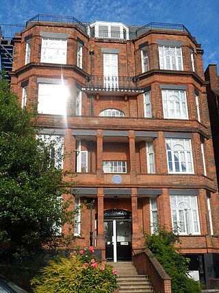
Eton Avenue is a street in the Belsize Park area of Hampstead in North London. Located in the London Borough of Camden, it runs eastward from Swiss Cottage tube station to a junction with England's Lane and Belsize Park Gardens by The Washington pub.

Belsize Lane is a street in the Belsize Park area of Hampstead in London. Located in the London Borough of Camden, it runs east to west from Haverstock Hill to Fitzjohns Avenue. While residential for much of the route, it also features a group of commercial properties that form the centre of Belsize Village. The Tavistock Clinic is located at its western end.

Well Road is a street in Hampstead, England located in the London Borough of Camden. It runs westwards from Hampstead Heath to New End Square. Well Walk runs parallel to its south and the two are linked by Wells Passage. When the Hampstead Wells were in existence, a large pump room and assembly room were located on Well Walk, with the water supplied from the headspring on Well Road.

New End Square is a square in Hampstead, located in the London Borough of Camden. It dates back to the early eighteenth century when it was located close to the Hampstead Wells spa on the adjacent Well Walk. Despite its name it is not rectangular. At its northern end is the Old White Bear pub dating back to 1704, on the corner with Well Road. Its southern end is at the junction between Flask Walk and Well Walk. New End street curls off from one corner of the square, eventually heading west to Heath Street.

Flask Walk is a street in Hampstead in the London Borough of Camden. It runs eastwards from Hampstead High Street to a junction with Well Walk and New End Square. It is primarily residential but the western end of the street is a pedestrianised alley featuring commercial properties. Hampstead tube station is located close to the junction with the High Street.
North End Way is a street in Hampstead in the London Borough of Camden, today a stretch of the A502 road. At the boundary with the London Borough of Barnet it becomes North End Road running northwards into Golders Green where it terminates at the junction with Finchley Road, by the tube station. North End Way passes through Hampstead Heath.
Hampstead Way is a street at the northern edge of Hampstead. It is located primarily in the London Borough of Barnet although its southern end forms a border with the London Borough of Camden in which the rest of Hampstead is located. In the south it is part of the old hamlet of North End, which marked the northern boundary of Hampstead, but then curves northwards and follows the edge of Hampstead Heath into Golders Green and Hampstead Garden Suburb. The southern end leads off North End Way.

South End Road is located in Hampstead in the London Borough of Camden. It takes its name from the old "South End" of Hampstead. It runs southwards from the junction with East Heath Road and Downshire Hill alongside the southern edge of Hampstead Heath until reaching South End Green where it meets Pond Street and two roads running off east towards Gospel Oak. South Hill Park street runs north towards Hampstead Ponds. Keats Grove runs off the road and forms a triangle with Downshire Hill noted for its surviving Regency architecture.

Hampstead Grove is a street in Hampstead in the London Borough of Camden. It heads northwards from Holly Hill running towards Hampstead Heath, but curving back towards Lower Terrace which connects it to the Heath. It runs roughly parallel to Heath Street to its east. It takes its name from the groves of trees that marked the landscape.
Holly Hill is a street in Hampstead in the London Borough of Camden. It runs northwards from a junction with Hampstead High Street and Heath Street, Hampstead heading uphill to a grassy triangle named Holly Bush Hill where it meets Windmill Hill and Hampstead Grove by the entrance to Fenton House. It takes its name from a grove of holly bushes which stood on the hill until the 1940s. In the eighteenth century it was known as Cloth Hill, likely because local laundresses using Hampstead Wells hung their clothes out on the Holly Bushes to dry. Holly Mount turns eastwards off the street and forms a cul-de-sac, although there are steps linking it to Heath Street below. Holly Mount contains The Holly Bush pub, which was once linked to the nearby assembly rooms. Notable residents of Holly Hill have included the artists George Romney and Derek Hill, both commemorated with blue plaques. A number of properties are now Grade II listed. Romney's House at 5 Holly Bush Hill is Grade I listed. Running uphill to the west is Mount Vernon which also features notable historic properties and Holly Walk.

Maresfield Gardens is a street in Hampstead. Located in the London Borough of Camden, it runs parallel to the west of Fitzjohns Avenue for much of its route before curving to join it at is southern end. It crosses Nutley Terrace and Netherhall Gardens. The Belsize Tunnel passes underneath the street. It primarily feature red brick buildings.
Netherhall Gardens is a street in Hampstead, located in the London Borough of Camden. It connects Finchley Road with Fitzjohns Avenue, curving twice along its route and meeting Nutley Terrace and Maresfield Gardens. The short Netherhall Way connects it to Frognal. Belsize Tunnel carrying the Midland Main Line passes under the street.

Hampstead Hill Gardens is a street in Hampstead in the London Borough of Camden. It runs eastwards off the Rosslyn Hill stretch of the A502 road before looping round to join Pond Street to the south. The land was considered as a potential location for Hampstead Town Hall before a nearby site on Haverstock Hill was selected. The Hampstead Heath Tunnel of the North London Line passes under the street.


