Hampstead is an area in London, England, which lies four miles northwest of Charing Cross, and extends from the A5 road to Hampstead Heath, a large, hilly expanse of parkland. The area forms the northwest part of the London Borough of Camden, a borough in Inner London which for the purposes of the London Plan is designated as part of Central London.
The River Fleet is the largest of London's subterranean rivers, all of which today contain foul water for treatment. It has been used as a culverted sewer since the development of Joseph Bazalgette's London sewer system in the mid-19th century with the water being treated at Beckton Sewage Treatment Works. Its headwaters are two streams on Hampstead Heath, each of which was dammed into a series of ponds—the Hampstead Ponds and the Highgate Ponds—in the 18th century. At the southern edge of Hampstead Heath these descend underground as sewers and join in Camden Town. The waters flow 4 miles (6 km) from the ponds.
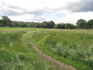
Hampstead Heath is an ancient heath in London, spanning 320 hectares. This grassy public space sits astride a sandy ridge, one of the highest points in London, running from Hampstead to Highgate, which rests on a band of London Clay. The heath is rambling and hilly, embracing ponds, recent and ancient woodlands, a lido, playgrounds, and a training track, and it adjoins the former stately home of Kenwood House and its estate. The south-east part of the heath is Parliament Hill, from which the view over London is protected by law.

Hampstead was a civil parish and metropolitan borough in London, England. It was an ancient parish in the county of Middlesex, governed by an administrative vestry. The parish was included in the area of responsibility of the Metropolitan Board of Works in 1855 and became part of the County of London in 1889. The parish of Hampstead became a metropolitan borough in 1900, following the London Government Act 1899, with the parish vestry replaced by a borough council. In 1965 the borough was abolished and its former area became part of the London Borough of Camden in Greater London.

The River Tyburn was a stream in London, England. Its main successor sewers emulate its main courses, but it resembled the Colne in its county of Middlesex in that it had many distributaries. It ran from South Hampstead, through Marylebone, Mayfair, St James's parish/district and Green Park to meet the tidal Thames at four sites, grouped into pairs. These pairs were near Whitehall Stairs, and by Thorney Street, between Millbank Tower and Thames House. Its much smaller cousin, the Tyburn Brook, was a tributary of the Westbourne and the next Thames tributary.

Hampstead & Highgate is a parliamentary constituency covering the northern half of the London Borough of Camden, which includes the village of Hampstead and part of Highgate. Since 2024, it has been represented by Tulip Siddiq.
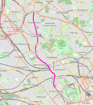
Finchley Road is a designated 4.5-mile (7-kilometre) arterial road in north-west London, England. The Finchley Road starts in St John's Wood near central London as part of the A41; its southern half is a major dual carriageway with high traffic levels often frequented by lorries and long-distance coaches as it connects central London, via the A41 Hendon Way, to the M1 motorway at Brent Cross and other roads at that interchange.

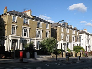
Belsize Park is a residential area of Hampstead in the London Borough of Camden, England.

Hampstead Heath Ponds are a series of some thirty bodies of water on or adjacent to Hampstead Heath, a vast open area of woodland and grassland in north London.
The London Borough of Barnet, located on the northern periphery of London and having much of the area within its boundaries in the Metropolitan Green Belt, has many parks and open spaces. In addition there are large areas taken over by cemeteries and golf courses, and part of Hampstead Heath.

Golders Hill Park is a formal park in Golders Green, London. It is managed by the City of London Corporation as part of the parkland and commons in and near Hampstead Heath, and is part of the Hampstead Heath Site of Metropolitan Importance for Nature Conservation. Unlike the rest of the Heath, Golders Hill Park is closed at night.

South Hill Park is a street in the Hampstead district of London. It is within the London Borough of Camden, and some of its houses overlook Hampstead Heath.
Haverstock is an area of the London Borough of Camden: specifically the east of Belsize Park, north of Chalk Farm and west of Kentish Town. It is centred on Queens Crescent and Malden Road. Gospel Oak is to the north, Camden Town to the south.

St. Stephen's is a former church building in Hampstead, London. It is sited on Rosslyn Hill at its junction with Pond Street, a steep slope adjacent to the Royal Free Hospital, and held up to 1,200 worshippers at its peak.

The Rosslyn Hill Unitarian Chapel is a place of worship in Hampstead, London. It is a member of the General Assembly of Unitarian and Free Christian Churches, the umbrella organisation for British Unitarians. It is also a Grade II Listed building.

The London Borough of Camden is a borough in Inner London, England. Camden Town Hall, on Euston Road, lies 1.4 mi (2.3 km) north of Charing Cross. The borough was established on 1 April 1965 from the former metropolitan boroughs of Holborn, St Pancras and Hampstead.

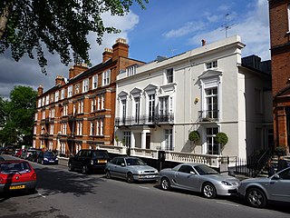
Downshire Hill is a street in Hampstead, London, in the London Borough of Camden. The street has always been a preferred residential address, in which the artist Dante Gabriel Rossetti and the actress Peggy Ashcroft as well as the scientist J. D. Bernal and Peter Medawar resided.

Pond Street is located in Hampstead in the London Borough of Camden. It runs eastwards from Rosslyn Hill to South End Green, located in the old "South End" of the settlement. The street takes its name from an ancient pond at South End Green, a source of the River Fleet, and has been known by this name since at least 1678. The pond survived into the Victorian era.

Hampstead High Street is located in the London Borough of Camden. It is the main high street for Hampstead Village and is part of the A502. Heading southeastwards from a junction with Heath Street and Holly Hill by Hampstead tube station it runs downhill and features a number of pubs, restaurants and shops before becoming Rosslyn Hill which connects it further on to Haverstock Hill, the whole stretch of which was one called Hampstead Road. Streets and alleys running off it include Flask Walk, Perrin Court and Prince Arthur Road.

Hampstead Hill Gardens is a street in Hampstead in the London Borough of Camden. It runs eastwards off the Rosslyn Hill stretch of the A502 road before looping round to join Pond Street to the south. The land was considered as a potential location for Hampstead Town Hall before a nearby site on Haverstock Hill was selected. The Hampstead Heath Tunnel of the North London Line passes under the street.

