Hampstead is an area in London, England, which lies 4 miles (6 km) northwest of Charing Cross, forming the northwest part of the London Borough of Camden, a borough in Inner London. It borders Highgate and Golders Green to the north, Belsize Park to the south and is surrounded from the northeast by Hampstead Heath, a large, hilly expanse of parkland.

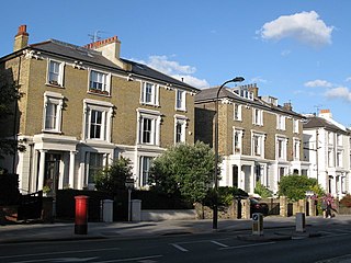
Belsize Park is a residential area of Hampstead in the London Borough of Camden, in the inner north-west of London, England.
Haverstock is an area of the London Borough of Camden: specifically the east of Belsize Park, north of Chalk Farm and west of Kentish Town. It is centred on Queens Crescent and Malden Road. Gospel Oak is to the north, Camden Town to the south.

Rosslyn Hill is a road in Hampstead, London, connecting the south end of Hampstead High Street to the north end of Haverstock Hill. It is the site of the Rosslyn Hill Unitarian Chapel, St. Stephen's Church and the Royal Free Hospital. It is served by the bus routes N5, C11, 46 and 268. Pond Street links it to Hampstead Heath railway station. Hampstead Hill Gardens runs between Rosslyn Hill and Pond Street.
Well Walk is a street in Hampstead, England in the London Borough of Camden. It runs southwestwards from Hampstead Heath to Flask Walk which then continues on towards the centre of Hampstead Village around the Hampstead tube station. It takes its name from the historic Hampstead Wells.

Eton Avenue is a street in the Belsize Park area of Hampstead in North London. Located in the London Borough of Camden, it runs eastward from Swiss Cottage tube station to a junction with England's Lane, Primrose Hill Road and Belsize Park Gardens by The Washington pub. Fellows Road and Adelaide Road run parallel to the south of Eton Avenue.
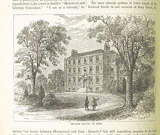
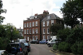
Belsize House was a historic residence in Belsize Park in what is today the London Borough of Camden. It was a country estate located south of Hampstead, which was then some distance away from the outskirts of the capital.

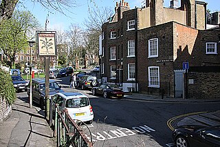
Belsize Lane is a street in the Belsize Park area of Hampstead in London. Located in the London Borough of Camden, it runs east to west from Haverstock Hill to Fitzjohns Avenue. While residential for much of the route, it also features a group of commercial properties that form the centre of Belsize Village. The Tavistock Clinic is located at its western end.

Well Road is a street in Hampstead, England in the London Borough of Camden. It runs westwards from Hampstead Heath to New End Square. Well Walk runs parallel to its south and the two are linked by Wells Passage. When the Hampstead Wells were in existence, a large pump room and assembly room were located on Well Walk, with the water supplied from the headspring on Well Road.

New End Square is a square in Hampstead, in the London Borough of Camden. It dates back to the early eighteenth century when it was located close to the Hampstead Wells spa on the adjacent Well Walk. Despite its name it is not rectangular. At its northern end is the Old White Bear pub dating back to 1704, on the corner with Well Road. Its southern end is at the junction between Flask Walk and Well Walk. New End street curls off from one corner of the square, eventually heading west to Heath Street.

Pond Street is located in Hampstead in the London Borough of Camden. It runs eastwards from Rosslyn Hill to South End Green, located in the old "South End" of the settlement. The street takes its name from an ancient pond at South End Green, a source of the River Fleet, and has been known by this name since at least 1678. The pond survived into the Victorian era.
North End Way is a street in Hampstead in the London Borough of Camden, today a stretch of the A502 road. At the boundary with the London Borough of Barnet it becomes North End Road running northwards into Golders Green where it terminates at the junction with Finchley Road, by the tube station. North End Way passes through Hampstead Heath.

Heath Street is in Hampstead in the London Borough of Camden, part of the A502 road for much of its route. It runs from the centre of Hampstead Village northwards towards Hampstead Heath. By Jack Straw's Castle it divides into North End Way heading towards North End and Spaniards Road heading towards Hampstead Garden Suburb and Highgate via Hampstead Lane. Streets running off it include Church Row, New End, Holly Hill, Hampstead Grove and Hampstead Square.

South End Road is located in Hampstead in the London Borough of Camden. It takes its name from the old "South End" of Hampstead. It runs southwards from the junction with East Heath Road and Downshire Hill alongside the southern edge of Hampstead Heath until reaching South End Green where it meets Pond Street and two roads running off east towards Gospel Oak. South Hill Park street runs north towards Hampstead Ponds. Keats Grove runs off the road and forms a triangle with Downshire Hill noted for its surviving Regency architecture.

Hampstead Grove is a street in Hampstead in the London Borough of Camden. It heads northwards from Holly Hill running towards Hampstead Heath, but curving back towards Lower Terrace which connects it to the Heath. It runs roughly parallel to Heath Street to its east. It takes its name from the groves of trees that marked the landscape.
Hampstead Square lies in Hampstead in the London Borough of Camden. It runs eastward off Heath Street and then curves southwards before Elm Row connects it again to Heath Street. It is linked by pedestrian access to Cannon Place.
Holly Hill is a street in Hampstead in the London Borough of Camden. It runs northwards from a junction with Hampstead High Street and Heath Street, Hampstead heading uphill to a grassy triangle named Holly Bush Hill where it meets Windmill Hill and Hampstead Grove by the entrance to Fenton House. It takes its name from a grove of holly bushes which stood on the hill until the 1940s. In the eighteenth century it was known as Cloth Hill, likely because local laundresses using Hampstead Wells hung their clothes out on the Holly Bushes to dry. Holly Mount turns eastwards off the street and forms a cul-de-sac, although there are steps linking it to Heath Street below. Holly Mount contains The Holly Bush pub, which was once linked to the nearby assembly rooms. Notable residents of Holly Hill have included the artists George Romney and Derek Hill, both commemorated with blue plaques. A number of properties are now Grade II listed. Romney's House at 5 Holly Bush Hill is Grade I listed. Running uphill to the west is Mount Vernon which also features notable historic properties and Holly Walk.

Belsize Avenue is a street in the Belsize Park area of Hampstead. Located in the London Borough of Camden, it runs from Haverstock Hill westwards to a junction with Belsize Terrace and Belsize Park Gardens. It is the former carriageway approach to Belsize House, a country estate that occupied the area until it was demolished in 1853 to allow residential development. A number of houses in the street were built by William Willett around 1873.

Hampstead Hill Gardens is a street in Hampstead in the London Borough of Camden. It runs eastwards off the Rosslyn Hill stretch of the A502 road before looping round to join Pond Street to the south. The land was considered as a potential location for Hampstead Town Hall before a nearby site on Haverstock Hill was selected. The Hampstead Heath Tunnel of the North London Line passes under the street.

Adelaide Road is a street in London running east to west between Chalk Farm and Swiss Cottage. Located in the London Borough of Camden it is part of the longer B509 route which continues as Belsize Road through South Hampstead. The Belsize Park area of Hampstead is to its north while Primrose Hill is to the south. It runs parallel to Fellows Road and Eton Avenue. Along its route it meets or is crossed by several streets including Primrose Hill Road and Avenue Road. At its eastern end is Chalk Farm tube station at the junction with Haverstock Hill, which opened in 1907. It takes its name from Queen Adelaide, wife of William IV.