Ponte do Castelo | |
|---|---|
| Coordinates | 40°51′06″N8°21′10″W / 40.851687°N 8.352742°W |
| Locale | Aveiro District, |
| Location | |
 | |

Ponte do Castelo is a bridge in Portugal. It is located in Aveiro District.
Ponte do Castelo | |
|---|---|
| Coordinates | 40°51′06″N8°21′10″W / 40.851687°N 8.352742°W |
| Locale | Aveiro District, |
| Location | |
| | |
Ponte do Castelo is a bridge in Portugal. It is located in Aveiro District.
| | This article about a bridge in Portugal is a stub. You can help Wikipedia by expanding it. |
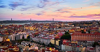
Lisbon is the capital and largest city of Portugal, with an estimated population of 548,703 as of 2022 within its administrative limits and 2,871,133 within the metropolis. Lisbon is mainland Europe's westernmost capital city and the only one along the Atlantic coast, the others being on islands. The city lies in the western portion of the Iberian Peninsula, on the northern shore of the River Tagus. The western portion of its metro area, the Portuguese Riviera, hosts the westernmost point of Continental Europe, culminating at Cabo da Roca.

Porto, also known as Oporto, is the second largest city in Portugal after Lisbon. It is the capital of the Porto District and one of the Iberian Peninsula's major urban areas. Porto city proper, which is the entire municipality of Porto, is small compared to its metropolitan area, with an estimated population of just 237,559 people in a municipality with only 41.42 km2 (16 sq mi). Porto's metropolitan area has around 1.7 million people (2021) in an area of 2,395 km2 (925 sq mi), making it the second-largest urban area in Portugal. It is recognized as a global city with a Gamma + rating from the Globalization and World Cities Research Network.

The Carnation Revolution, also known as the 25 April, was a military coup by military officers that overthrew the authoritarian Estado Novo government on 25 April 1974 in Lisbon, producing major social, economic, territorial, demographic, and political changes in Portugal and its overseas colonies through the Processo Revolucionário Em Curso. It resulted in the Portuguese transition to democracy and the end of the Portuguese Colonial War.

Trajan's Bridge is a Roman bridge in the civil parish of Santa Maria Maior, in the municipality of Chaves in the Portuguese northern subregion of Terras de Trás-os-Montes.

Olivenza or Olivença is a town in southwestern Spain, close to the Portugal–Spain border. It is a municipality belonging to the province of Badajoz, and to the wider autonomous community of Extremadura.

The Macau Peninsula is the historical and most populous part of Macau. It has an area of 8.5 square kilometers (3.3 sq mi) and is geographically connected to Guangdong Province at the northeast through an isthmus 200 meters (660 ft) wide. The peninsula, together with downtown Zhuhai, sits on an island separated from the continent by distributaries of the Pearl River. The Border Gate was built on the northern isthmus. At the south, the peninsula is connected to Taipa Island by three bridges, the Friendship Bridge ; the Macau-Taipa Bridge ; and the Sai Van Bridge . The longest axis extends 4 kilometers (2.5 mi) from the Border Gate to the southwestern edge, Barra (媽閣嘴). There is a western "Inner Harbor" (內港) paralleled by an "Outer Harbor" (外港) to the east. The 93 meters (305 ft) Guia Hill (松山) is the highest point on the peninsula, which has an average elevation of 50 to 75 meters. Many coastal places are reclaimed from the sea. The Historic Centre of Macau, which is entirely on the Macau Peninsula, became a World Heritage Site in 2005.
The Regional Flag of the Macau Special Administrative Region of the People's Republic of China is light green with a lotus flower above the stylised Governador Nobre de Carvalho Bridge and water in white, beneath a circular arc of five golden five-pointed stars: one large star in the center of the arc with two smaller stars on each side of the large star, each with a point angled directly outward from the center of the common circle on which they lie.

Tete is the capital city of Tete Province in Mozambique. It is located on the Zambezi River, and is the site of two of the four bridges crossing the river in Mozambique. A Swahili trade center before the Portuguese colonial era, Tete continues to dominate the west-central part of the country and region, and is the largest city on the Zambezi. In the local language, Nyungwe, Tete means "reed".

The Vasco da Gama Bridge is a cable-stayed bridge flanked by viaducts that spans the Tagus River in Parque das Nações in Lisbon, the capital of Portugal.

The 25 de Abril Bridge is a suspension bridge connecting the city of Lisbon, capital of Portugal, to the municipality of Almada on the left (south) bank of the Tagus River. It has a main span length of 1,013 metres (3,323 ft), making it the 48th longest suspension bridge in the world.

The Arrábida Bridge is an arch bridge of reinforced concrete which carries six lanes of traffic over the Douro River, between Porto and Vila Nova de Gaia, in the Norte region of Portugal.

The Combat of the Côa was a military engagement that occurred during the Peninsular War period of the Napoleonic Wars. It took place in the valley of the Côa River and it was the first significant battle for the new army of 65,000 men controlled by Marshal André Masséna, as the French prepared for their third invasion of Portugal.
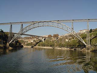
The Maria Pia Bridge is a railway bridge built in 1877, and attributed to Gustave Eiffel, situated over the Portuguese northern municipalities of Porto and Vila Nova de Gaia.

The Dom Luís I Bridge, or Luís I Bridge, is a double-deck metal arch bridge that spans the river Douro between the cities of Porto and Vila Nova de Gaia in Portugal. At its construction, its 172 metres (564 ft) span was the longest of its type in the world. It can be confused with the nearby Maria Pia Bridge, a railway bridge that was built 9 years earlier, which is similar in aspect to the Luís I bridge.

In the Blockade of Almeida a French garrison under Antoine François Brenier de Montmorand was surrounded by approximately 13,000 Anglo-Allied soldiers led by Generals Sir Alexander Campbell, 1st Baronet and Sir William Erskine, 2nd Baronet.

The Battle of Almaraz was fought during the Peninsular War on 18–19 May 1812, in which the Anglo-Portuguese Army under Lord Hill destroyed a French pontoon bridge across the River Tagus, in Almaraz, Spain. The bridge was protected by two French garrisons at either end.
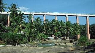
Aqueducts are bridges constructed to convey watercourses across gaps such as valleys or ravines. The term aqueduct may also be used to refer to the entire watercourse, as well as the bridge. Large navigable aqueducts are used as transport links for boats or ships. Aqueducts must span a crossing at the same level as the watercourses on each end. The word is derived from the Latin aqua ("water") and ducere, therefore meaning "to lead water". A modern version of an aqueduct is a pipeline bridge. They may take the form of tunnels, networks of surface channels and canals, covered clay pipes or monumental bridges.
The Brazilian Bridge Federation is the national organization for bridge in Brazil and a member of the Confederacion Sudamericana de Bridge and the World Bridge Federation. It was founded in 1945 as the Confederação Brasileira de Bridge, affiliated with the World Bridge Federation in 1979, and fully recognized by it in June 1999.