Related Research Articles

Kensington is an area of London in the Royal Borough of Kensington and Chelsea, around 2.9 miles (4.6 km) west of Central London.
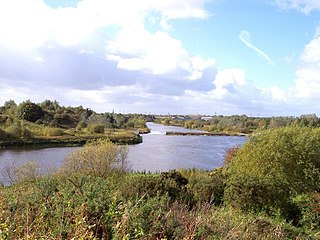
Woolston is a settlement and civil parish in the Borough of Warrington in the county of Cheshire, England. Formerly a township called 'Woolston with Martinscroft' within the parish of Warrington, there are two main settlements: Woolston to the west and Martinscroft to the east. Formerly within the historic county of Lancashire, the parish is on the north bank of the River Mersey and takes in Paddington to the south-west. It is bounded by the River Mersey to the south, Bruche and Padgate to the west, Longbarn and Birchwood to the north and Rixton to the east.

High Street Kensington is a London Underground station on Kensington High Street, in Kensington. The station is on the Circle line between Gloucester Road and Notting Hill Gate, and the District line between Earl's Court and Notting Hill Gate and is in Travelcard Zone 1. Kensington Arcade forms the entrance to the station.

Kensington High Street is the main shopping street in Kensington, London, England. The area is identified in the London Plan as one of 35 major centres in Greater London.

The Lillie Bridge Grounds was a sports ground on the Fulham side of West Brompton, London. It opened in 1866, coinciding with the opening of West Brompton station. It was named after the local landowner, Sir John Scott Lillie (1790–1868) and the Lillie bridge over the West London Line, that links Old Brompton Road with Lillie Road. The grounds were adjacent to the railway on the south side of Lillie Road. Although geographically near to present day Stamford Bridge, there was never direct access, there being the 13 acre now defunct Western Hospital site between the two. The ground was the scene in its day of many sports including athletics, boxing, cricket, cycling and football, and hosted the FA Cup Final in 1873. It closed in 1888 following a riot reported in The Times.

Brompton, sometimes called Old Brompton, survives in name as a ward in the Royal Borough of Kensington and Chelsea in London. Until the latter half of the 19th century it was a scattered village made up mostly of market gardens in the county of Middlesex. It lay southeast of the village of Kensington, abutting the parish of St Margaret's, Westminster at the hamlet of Knightsbridge to the northeast, with Little Chelsea to the south. It was bisected by the Fulham Turnpike, the main road westward out of London to the ancient parish of Fulham and on to Putney and Surrey. It saw its first parish church, Holy Trinity Brompton, only in 1829. Today the village has been comprehensively eclipsed by segmentation due principally to railway development culminating in London Underground lines, and its imposition of station names, including Knightsbridge, South Kensington and Gloucester Road as the names of stops during accelerated urbanisation, but lacking any cogent reference to local history and usage or distinctions from neighbouring settlements.
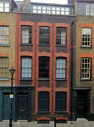
Fournier Street, formerly Church Street, is a street of 18th-century houses in Spitalfields in the East End of London. It is in the London Borough of Tower Hamlets and runs between Commercial Street and Brick Lane. The street is named after a man of Huguenot extraction, George Fournier.
The Borough Compter was a small compter or prison initially located in Southwark High Street but moved to nearby Tooley Street in 1717, where it stood until demolished until 1855. It took its name from 'The Borough', a historic name for the Southwark area of London on the south side of the River Thames from the City of London. This replaced a lock-up as part of the city's court house under the jurisdiction of the Lord Mayor and Court of Aldermen of the city, and their High-Bailiff of Southwark. This first court house was converted from the old church of the parish St Margaret. A floor was made across the level of the church's gallery and the windows below that were blocked in, the Court Room being on the first floor. This structure was destroyed in the Great Fire of Southwark in 1676.
Robert Richardson Banks was a notable English architect of the mid 19th century who worked for many years in partnership with Charles Barry.

Stoke-by-Clare is a small village and civil parish in Suffolk located in the valley of the River Stour, about two miles west of Clare.

Francis Smith of Warwick (1672–1738) was an English master-builder and architect, much involved in the construction of country houses in the Midland counties of England. Smith of Warwick may refer also to his brothers, or his son.
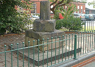
Mab's Cross, in Wigan, Greater Manchester, England, is a stone cross probably dating from the 13th century with its first recorded mention taking place in 1277. It is one of four stone crosses originally used as waymarkers along the medieval route from Wigan to Chorley. The cross no longer stands in its original position, having been moved across the road in 1922 as part of a road widening scheme.

St Pancras, Soper Lane, was a parish church in the City of London, in England. Of medieval origin, it was destroyed in the Great Fire of London in 1666 and not rebuilt.

Christ Church and its burial grounds in Worthing, England, were consecrated in 1843 by the Bishop of Chichester, Ashurst Turner Gilbert, to meet the need for church accommodation for the poor. Built by subscription between 1840 and 1843, the Church was initially regarded as a chapel of ease to St Mary's Church in Broadwater. The chapel of ease was upgraded to the status of church with its own parish in 1855.

Pembroke Square is located in the Kensington area of southwest central London, England. The whole square is Grade II listed for its architectural merit. It was developed by the Hawks family.

The Kingston House estate and Ennismore Gardens in Knightsbridge is a green, dual-character area within the western limits of the City of Westminster in London. The first-named is immediately south of Hyde Park, London taking up the park's semi-panorama row of 8 to 13 Princes Gate (demolished) and otherwise, as to more of its wings, set around the east of Princes Gate Garden including a terrace of houses №s 1 to 7 Bolney Gate. The second-named is a garden square of 59 tall creamy-white terraced houses and the approach road to Prince of Wales Gate, Hyde Park as well as the identical-size public, square green of the church that is since 1956 the Russian Orthodox Cathedral of the Dormition of the Mother of God and All Saints facing which green are its anomalous outlier row for a London garden square, №s 61 to 66. The relatively small, broad-fronted house set against the Consulate-used pairing at №s 61 to 62 is № 60 and as with the other 65 numbers of Ennismore Gardens is a listed building.

James Bonnin was an English property developer who built more than three hundred houses in the Brompton, Kensington, Knightsbridge and Chelsea areas of London. In 1846, he was declared bankrupt, and decided to emigrate in 1849, but died a few days after arriving in Adelaide, South Australia.

Barkers of Kensington was a department store in Kensington High Street, Kensington, London. It began as a small drapery business, John Barker & Company, founded by John Barker and James Whitehead in 1870. Barkers grew rapidly to become one of London's largest and most well-known department stores.

Sir John de Pulteney was a major English entrepreneur and property owner, who served four times as Lord Mayor of London.
Stoke-by-Clare Priory was a Benedictine monastery in Stoke-by-Clare, in Suffolk, an alien priory, dependent on Bec Abbey, in Normandy. Reinstituted in 1124, the Priory was suppressed in 1415.
References
- ↑ P.O.D.: Peel, op. cit., pp. 39–40. From: 'Kensington High Street, south side: Kensington Court to Wright's Lane', Survey of London: volume 42: Kensington Square to Earl's Court (1986), pp. 77-98. URL: http://www.british-history.ac.uk/report.aspx?compid=50310 Date accessed: 30 October 2014.
- ↑ Adburgham, op. cit., pp. 164–5. From: 'Kensington High Street, south side: Kensington Court to Wright's Lane', Survey of London: volume 42: Kensington Square to Earl's Court (1986), pp. 77-98. URL: http://www.british-history.ac.uk/report.aspx?compid=50310 Date accessed: 30 October 2014.
- ↑ "HOUSE OF FRASER Archive :: Company: Ponting Brothers".
- ↑ P.R.O., BT 31/7991/57434: The Warehouseman and Draper,25 March 1899, p. 443 From: 'Kensington High Street, south side: Kensington Court to Wright's Lane', Survey of London: volume 42: Kensington Square to Earl's Court (1986), pp. 77–98. URL: http://www.british-history.ac.uk/report.aspx?compid=50310 Date accessed: 30 October 2014.
- ↑ The Warehouseman and Draper, 1 July 1899, pp. 891–2: B. 20 May 1899, p. 513. From: 'Kensington High Street, south side: Kensington Court to Wright's Lane', Survey of London: volume 42: Kensington Square to Earl's Court (1986), pp. 77-98. URL: http://www.british-history.ac.uk/report.aspx?compid=50310 Date accessed: 30 October 2014.
- ↑ B.A. 30948, Corr. I; 38885: K.P.L., M.B.W./L.C.C. planning applications, no. 751. From: 'Kensington High Street, south side: Kensington Court to Wright's Lane', Survey of London: volume 42: Kensington Square to Earl's Court (1986), pp. 77-98. URL: http://www.british-history.ac.uk/report.aspx?compid=50310 Date accessed: 30 October 2014.
- ↑ B. 30 July 1910, p. 128: P.R.O., BT 31/7991/57434: Peel, op. cit., p. 40: HF 8/1/5. From: 'Kensington High Street, south side: Kensington Court to Wright's Lane', Survey of London: volume 42: Kensington Square to Earl's Court (1986), pp. 77-98. URL: http://www.british-history.ac.uk/report.aspx?compid=50310 Date accessed: 30 October 2014.
- ↑ "HOUSE OF FRASER Archive :: Company: Ponting Brothers".
- ↑ "The lost department store | The Library Time Machine". 13 October 2011.
- ↑ HF 8/1/6: B.R. 57808, Corr. I. From: 'Kensington High Street, south side: Kensington Court to Wright's Lane', Survey of London: volume 42: Kensington Square to Earl's Court (1986), pp. 77-98. URL: http://www.british-history.ac.uk/report.aspx?compid=50310 Date accessed: 30 October 2014.
- ↑ HF 8/1/8–9: B.R. 57808, Corr. I: The Architects’ Journal, 9 Jan. 1936, pp. 63, 69. From: 'Kensington High Street, south side: Kensington Court to Wright's Lane', Survey of London: volume 42: Kensington Square to Earl's Court (1986), pp. 77-98. URL: http://www.british-history.ac.uk/report.aspx?compid=50310 Date accessed: 30 October 2014.
- ↑ "HOUSE OF FRASER Archive :: Company: Ponting Brothers".
- ↑ "HOUSE OF FRASER Archive :: Company: Ponting Brothers".
- ↑ "Kensington Super store". Pinterest. Retrieved 23 May 2024.
- ↑ Information kindly supplied by the English Property Corporation and the GMW Partnership. From: 'Kensington High Street, south side: Kensington Court to Wright's Lane', Survey of London: volume 42: Kensington Square to Earl's Court (1986), pp. 77-98. URL: http://www.british-history.ac.uk/report.aspx?compid=50310 Date accessed: 30 October 2014.
- ↑ "The lost department store | The Library Time Machine". 13 October 2011.