
The Brecon Beacons, or Bannau Brycheiniog ( ), is a mountainous region and national park in Wales. The name 'Brecon Beacons' was originally applied only to the mountain range south of Brecon, Powys, which is now also known as the Central Beacons. The range includes South Wales' highest mountain, Pen y Fan, its twin summit Corn Du, and Craig Gwaun Taf, which are the three highest peaks in the range.

Brecknockshire, also known as the County of Brecknock, Breconshire, or the County of Brecon is one of thirteen historic counties of Wales, and a former administrative county. Named after its county town of Brecon, the county is mountainous and primarily rural.

Merthyr Tydfil is the main town in Merthyr Tydfil County Borough, Wales, administered by Merthyr Tydfil County Borough Council. It is about 23 miles (37 km) north of Cardiff. Often called just Merthyr, it is said to be named after Tydfil, daughter of King Brychan of Brycheiniog, who according to legend was slain at Merthyr by pagans about 480 CE. Merthyr generally means "martyr" in modern Welsh, but here closer to the Latin martyrium: a place of worship built over a martyr's relics. Similar place names in south Wales are Merthyr Cynog, Merthyr Dyfan and Merthyr Mawr.

The Taff Trail is a popular walking and cycle path that runs for 55 miles (89 km) between Cardiff Bay and Brecon in Wales. It is so named because it follows the course of the River Taff. Along much of its length, it follows the National Cycle Network Route 8 that continues to Holyhead, and is substantially off-road.

The River Taff is a river in Wales. It rises as two rivers in the Brecon Beacons; the Taf Fechan and the Taf Fawr before becoming one just north of Merthyr Tydfil. Its confluence with the River Severn estuary is in Cardiff.

The Brecon Mountain Railway is a 1 ft 11+3⁄4 in narrow gauge tourist railway on the south side of the Brecon Beacons. It climbs northwards from Pant along the full length of the Pontsticill Reservoir and continues past the adjoining Pentwyn Reservoir to Torpantau railway station. The railway's starting point at Pant is located two miles (3 km) north of the town centre of Merthyr Tydfil, Merthyr Tydfil County Borough, South-East Wales.

Vaynor is a village and community in Merthyr Tydfil County Borough in Wales, United Kingdom. The population of the community at the 2011 census was 3,551.

Cefn yr Ystrad is a mountain in the Brecon Beacons National Park in Wales. It is an outlier of the Central Beacons group.
The Nedd Fechan is a river almost wholly within the county of Powys, Wales, currently administered as part of the unitary authority of Powys. It rises on the eastern slopes of Fan Gyhirych in the Fforest Fawr section of the Brecon Beacons National Park and flows south for 7 miles (12 km) to join with the Afon Mellte at Pontneddfechan, their combined waters continuing as the River Neath to the sea near Swansea. The only significant tributary of the Nedd Fechan is the Afon Pyrddin which joins it at Pwll Du ar Byrddin. Downstream of this confluence it forms the boundary between Powys to its east and Neath Port Talbot to its west.
The Afon Pyrddin is a river forming a short section of the boundary between the counties of Brecknockshire and Glamorgan in Wales, United Kingdom. It also forms a part of the boundary of the Brecon Beacons National Park, and the boundary of the unitary authorities of Powys and Neath Port Talbot. The river and its waterfalls are one of the key attractions of the Fforest Fawr Geopark designated in 2005.
The Nant Llech is a minor river in Powys, Wales and which lies wholly within the Brecon Beacons National Park. The name means 'slab stream', presumably in reference to the sandstones across which it runs. Its headwater streams, the Nant Llech Pellaf and the Nant Llech Isaf join forces at Blaen Llech and then continue westwards as the Nant Llech for 3 km / 2 mi to a confluence with the River Tawe just east of the village of Abercraf.
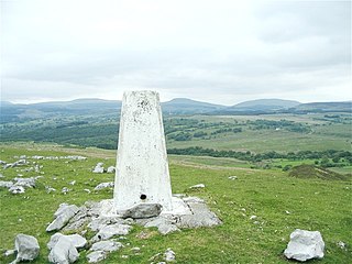
Moel Penderyn is a hill on the edge of Penderyn village, in the Brecon Beacons National Park in the county borough of Rhondda Cynon Taff, south Wales. It also appeared on older maps as 'Y Foel Penderyn'. Its summit at 371m is marked by a trig point.
Crai is a village in the Brecon Beacons National Park in the county of Powys, Wales and the historic county of Breconshire. The population of Cray community at the 2011 census was 241. Within the community are the hamlet of Felin-Crai and many dispersed farms around the valley of the Afon Crai. The river is dammed 2 km / 1.5 mi southwest of the village to form Cray Reservoir. Crai means fresh, raw water. The famous Llywel Stone was found close to the Crai/Trecastle boundary. A history of the village is contained in Lewis, D. Craionog: Hanes plwyf Defynog : yn cynnwys y rhanbarthau cynlynol; Crai, Glyntawy, Senni, Glyntarell, a Maescar. Merthyr Tydfil : H. W. Southey a'i Feibion, Cyf, Argrffwyr, 1911.

Pontsticill Reservoir or Taf Fechan Reservoir is a large reservoir on the Taf Fechan lying partly in the county of Powys and partly within the county borough of Merthyr Tydfil in south Wales. It lies within the Brecon Beacons National Park and Fforest Fawr Geopark.

Aber Village or Aber Clydach is a hamlet within the Brecon Beacons National Park in Powys, Wales. It is centred on the minor road which runs south from Talybont-on-Usk up the Caerfanell valley known as Glyn Collwn across the Brecon Beacons to Pontsticill and Merthyr Tydfil. Aber Clydach lies within the community of Talybont-on-Usk about 1.5 km to the south of the village of Talybont and 0.5 km to the north of the dam of Talybont Reservoir.

Cefn-coed-y-cymmer is a small community on the northwestern edge of Merthyr Tydfil County Borough in Wales. It is situated in the neck of land between the rivers Taf Fawr and Taf Fechan at their confluence. The village lies within the community of Vaynor. Immediately to the north of the village is the hill of Cefn Cil Sanws on the southern slopes of which is Merthyr Tydfil Golf Club. The village is bounded both to the north and the west by the Brecon Beacons National Park.
Abercriban Quarries is a Site of Special Scientific Interest in Brecknock, Powys, Wales.

Torpantau railway station is a station in the Welsh county of Brecknockshire, and the northern terminus of the narrow gauge Brecon Mountain Railway.

Pant railway station is the southern terminus of the Brecon Mountain Railway, a heritage line on the southern edge of the Brecon Beacons National Park in Wales.
