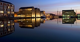
Gloucester is a cathedral city and the county town of Gloucestershire in the South West of England. Gloucester lies on the River Severn, between the Cotswolds to the east and the Forest of Dean to the west; it is sited 19 miles (31 km) east of Monmouth and 17 miles (27 km) east of the border with Wales. Gloucester has a population of around 132,000, including suburban areas. It is a port, linked via the Gloucester and Sharpness Canal to the Severn Estuary.

The Forest of Dean is a geographical, historical and cultural region in the western part of the county of Gloucestershire, England. It forms a roughly triangular plateau bounded by the River Wye to the west and northwest, Herefordshire to the north, the River Severn to the south, and the City of Gloucester to the east.

Cinderford is a town and civil parish on the eastern fringe of the Forest of Dean in Gloucestershire, England. The population was 8,777 at the 2021 Census.

The A417 is a main road in England, running from Streatley, Berkshire to Hope under Dinmore, Herefordshire. It is best known for its section between Cirencester and Gloucester where it has primary status and forms part of the link between the major settlements of Swindon and Gloucester.

Whitminster is a village and civil parish in Gloucestershire, England, on the A38 trunk road approximately 6 miles (10 km) south of Gloucester and 6 miles (10 km) north-west of Stroud. The parish population at the 2011 census was 881. The hamlet of Wheatenhurst is signposted from the A38 at Whitminster. Whitminster is close to Junction 13 of the M5 motorway, with Bristol, South Wales and the south Midlands all within an hour's drive.
Stonehouse is a town in the Stroud District of Gloucestershire in southwestern England.

Abbeydale and Abbeymead are modern suburbs of the city of Gloucester in the county of Gloucestershire, England. They lie approximately 3 miles south-east of the city centre, and are bounded by the suburbs of Coney Hill to the north west, Barnwood and Hucclecote to the north and north east, Matson to the south west and the M5 motorway to the south and east. Mostly connected with Segregated Bicycle Paths into Gloucester city along Metz Way. The village of Upton St Leonards is directly across the M5 motorway.

Newport is a village in Alkington parish, Gloucestershire, England. Located along the A38 road roughly halfway between Bristol and Gloucester. It is located about a mile south-east of Berkeley and just north of Woodford. It is on the Doverte Brook, a tributary of the Little Avon River. Its pub, formerly the White Hart, closed in 2021 and is now a Day Nursery. A closed down motel is being redeveloped as a housing estate, and there is a small non-conformist chapel. The chapel is closed on October 2006 and has been converted into a house. It had a Georgian Interior with hat pegs and galleries and several broken harmoniums. Prior to the advent of the motor car, the journey between Bristol and Gloucestershire took a whole day. It was a perfect staging point for stagecoaches at that time. There were many inns, some catering for the post. The coaches would have a change of horses, the coachmen and passengers having a mid-journey rest stop.
North Common is a village just outside Warmley, Bristol, in South Gloucestershire, England. Historically this was a rural hamlet surrounded by farmland. The residents are fortunate enough that to the east of the village is attractive rolling countryside, with views of Lansdown, and the surrounding hills. The village is on the eastern outskirts of Bristol and approximately halfway between Bristol city centre and the neighbouring city of Bath.

Whiteladies Road is a main road in Bristol, England. It runs north from the Victoria Rooms to Durdham Down, and separates Clifton on the west side from Redland and Cotham on the east. It forms part of the A4018.
The Severn Valley is a rural area of the West Midlands region of England, through which the River Severn runs and the Severn Valley Railway steam heritage line operates, starting at its northernmost point in Bridgnorth, Shropshire and running south for 16 miles (26 km) to Ribbesford, a few miles south of Bewdley, Worcestershire in the Wyre Forest.

Llannon is a small village, community and electoral ward in the county of Carmarthenshire, Wales. It is located on the A476 road 11 mi (18 km) south east of the county town, Carmarthen, between Tumble and Swiss Valley.

Flaxley is a small settlement and former civil parish, now in the parish of Blaisdon, in the Forest of Dean, Gloucestershire, England. It is located in between the larger villages of Westbury-on-Severn and Mitcheldean. In 1931 the parish had a population of 87.

Frampton Mansell is a small English village 5 miles east-south-east of Stroud, Gloucestershire, in the parish of Sapperton. It lies off the A419 road between Stroud and Cirencester. It has a prominent mid-19th century, Grade II listed church with a set of five original stained-glass windows.
Mayshill or Mays Hill is a hamlet located in the Parish of Westerleigh, South Gloucestershire, England. It is located just off the A432 between Coalpit Heath and Nibley. A small road runs from the hamlet to Frampton End Road, connecting Frampton Cotterell and Iron Acton. Yate and Westerleigh are also nearby. Despite its size the hamlet contains a pub, dating from the 16th Century. The 'New Inn at Mays Hill', on Badminton Road, there is also a house opposite the pub dating from the 17th Century. Mayshill Cemetery, is located across Badminton Road

St Briavels was an ancient hundred of Gloucestershire, England. It comprised the extra-parochial area of the Forest of Dean, and the ancient parishes of

The Westgate area of Gloucester is centred on Westgate Street, one of the four main streets of Gloucester and one of the oldest parts of the city. The population of the Westgate ward in Gloucester was 6,687 at the time of the 2011 Census.

The Five Mile House is a former pub on Old Gloucester Road, Duntisbourne Abbots, Gloucestershire, England. It was built in the 17th century and is grade II listed.
