
The Forest of Dean is a geographical, historical and cultural region in the western part of the county of Gloucestershire, England. It forms a roughly triangular plateau bounded by the River Wye to the west and northwest, Herefordshire to the north, the River Severn to the south, and the City of Gloucester to the east.

Cinderford is a town and civil parish on the eastern fringe of the Forest of Dean in Gloucestershire, England. The population was 8,777 at the 2021 Census.

Parkend is a village, located at the foot of the Cannop Valley, in the Royal Forest of Dean, West Gloucestershire, England, and has a history dating back to the early 17th century. During the 19th century it was a busy industrial village with several coal mines, an ironworks, stoneworks, timber-yard and a tinplate works, but by the early 20th century most had succumbed to a loss of markets and the general industrial decline. In more recent times, the village has become a tourist destination.

Forest of Dean is a local government district in Gloucestershire, England, named after the Forest of Dean. Its council is based in Coleford. Other towns and villages in the district include Blakeney, Cinderford, Drybrook, English Bicknor, Huntley, Littledean, Longhope, Lydbrook, Lydney, Mitcheldean, Newnham and Newent.

Tintern is a village in the community of Wye Valley, on the west bank of the River Wye in Monmouthshire, Wales, close to the border with England, about 5 miles (8.0 km) north of Chepstow. It is popular with tourists, in particular for the scenery and the ruined Tintern Abbey. Modern Tintern has been formed through the coalescence of two historic villages; Tintern Parva, forming the northern end of the village, and Chapel Hill, which forms the southern end. The village is designated as a Conservation Area.

Shelsley Walsh is a small village and civil parish in Worcestershire, England, on the western side of the River Teme. For administrative purposes it is presently located in the Teme Valley ward of the county’s Malvern Hills district. In the 2011 Census there was an estimated population of 28 people in 12 households. The site has been farmed since Anglo Saxon times and there are also vestiges of former industry, but it is now best known for its association with the Shelsley Walsh Speed Hill Climb.
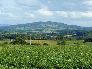
May Hill is a prominent English hill between Gloucester and Ross-on-Wye. Its summit, on the western edge of Gloucestershire and its northern slopes in Herefordshire, is distinguishable by a clump of trees on its summit, which forms an official Site of Special Scientific Interest. It is reached by three public footpaths, two as parts of the Gloucestershire Way and Wysis Way.

Abenhall is a small village and former civil parish, now in the parish of Mitcheldean, in the Forest of Dean district, in the county of Gloucestershire, England. It lies on the road between Mitcheldean and Flaxley in the Forest of Dean. The parish included the settlement of Plump Hill, which is actually more populous than Abenhall itself, and was once part of the Hundred of St Briavels. Originally a mining and iron-making centre like much of the surrounding area, the village is notable for its 14th century Church of St Michael, which is built of local red sandstone and has ornate contemporary carvings relating to the Forest of Dean's principal industries. These include a shield bearing the arms of the Freeminers on the west wall and a mid-15th century octagonal font, that has tools of miners and metalworkers incised on its sides. Abenhall is a tiny, ancient village in a secluded quiet valley near Mitcheldean. The parish includes the settlement of Plump Hill, on the Mitcheldean to Cinderford Road as it climbs into the high Forest. Abenhall is on the Flaxley to Mitcheldean Road. Originally a mining and iron making centre, it is notable for its 14th century Church of St Michael, which is built of local red sandstone and has excellent contemporary carvings relating to the Forest of Dean's industries. These include a shield bearing the arms of the Freeminers on the west wall and the fabulous mid-15th century octagonal font, that has tools of miners and metalworkers incised on its sides. In the west tower is a spectacular new window installed 14 April 2011 by stained glass artist Thomas Denny; presented by the current free miners of the Forest of Dean to represent their gratitude and present day continuation of the ancient local customs of coal, iron ore and stone mining. In 1931 the parish had a population of 230.
Seend Ironstone Quarry and Road Cutting is a 3 acres (1.2 ha) Geological Site of Special Scientific Interest at Seend in Wiltshire, England, notified in 1965. The site contains facies of Lower Greensand containing specimens of fauna not found elsewhere.

Wakerley is a linear village and civil parish in the county of Northamptonshire, England. Forming part of North Northamptonshire, Wakerley is close to, and south of, the River Welland that forms the boundary with Rutland; its nearest neighbour, Barrowden, is in that county and accessible by a footbridge. Wakerley is in the area of Rockingham Forest and Wakerley Great Wood is one of the forest's largest remnants. The population of the village is included in the civil parish of Duddington with Fineshade.

Lydbrook is a civil parish in the Forest of Dean, a local government district in the English county of Gloucestershire and is located in the Wye Valley. It is on the north west edge of the Forest of Dean's present legal boundary proper. It comprises the districts of Lower Lydbrook, Upper Lydbrook, Joys Green and Worrall Hill. It has a mile and a half long high street, reputed to be the longest high street of any village in England.

Northchapel is a village and civil parish in Chichester District in West Sussex, England. It stands on the A283 road just south of the Surrey border, around 9 km north of Petworth.

Flaxley Abbey is a former Cistercian monastery in England, now a Grade I listed manor and private residence, near the village of Flaxley in the Forest of Dean, Gloucestershire. It is the former seat of the Crawley-Boevey Baronets.
Pope's Hill is a hill and a small village situated in the east of the Forest of Dean, Gloucestershire within the parish of Littledean. The hill is 12 miles south west of Gloucester and 3 miles east of Cinderford. The small village of Flaxley lies in the valley to the immediate north. Pope's Hill is said to have got its name from Mary Pope, who used to reside in Flaxley Abbey in the 18th century and walked over the hill as a young girl. She is buried in Flaxley churchyard.

Pidcock's Canal was a canal in Gloucestershire, England, which connected ironworks at Upper Forge and Lower Forge, and also ran to an inlet from the River Severn called Lydney Pill. It was constructed from 1778 onwards, and there were three locks below Middle Forge. Following the construction of the Lydney Canal in 1813, the canal connected to that, rather than Lydney Pill, and it was disused after 1840, by which time a horse-drawn tramway had been built up the valley of The Lyd. The tramway was eventually relaid as a steam railway and is now preserved as the Dean Forest Railway. Most of the canal, colloquially called The Cut, still exists below Middle Forge.
The Medway and its tributaries and sub-tributaries have been used for over 1,150 years as a source of power. There are over two hundred sites where the use of water power is known. These uses included corn milling, fulling, paper making, iron smelting, pumping water, making gunpowder, vegetable oil extraction, and electricity generation. Today, there is just one watermill working for trade. Those that remain have mostly been converted. Such conversions include a garage, dwellings, restaurants, museums and a wedding venue. Some watermills are mere derelict shells, lower walls or lesser remains. Of the majority, there is nothing to be seen. A large number of tributaries feed into the River Medway. The tributaries that powered watermills will be described in the order that they feed in. The mills are described in order from source to mouth. Left bank and right bank are referred to as though the reader is facing downstream. This article covers the tributaries that feed in above Penshurst.
Lying close to the village of Soudley in the Forest of Dean, west Gloucestershire, Soudley Ponds, also known as Sutton Ponds, comprise four linked man-made ponds lined in succession through the narrow Sutton Valley, and surrounded by stands of tall Douglas Fir. It is a 7.04-hectare (17.4-acre) biological Site of Special Scientific Interest notified in 1984.

Westbury Brook Ironstone Mine is a 15.69-hectare (38.8-acre) biological Site of Special Scientific Interest in Gloucestershire, notified in 1998.
Wigpool Ironstone Mine is a 34.88-hectare (86.2-acre) biological Site of Special Scientific Interest in Gloucestershire, notified in 1998.


