Mitcheldean | |
---|---|
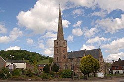
Church of St Michael and All Angels, Mitcheldean | |
Location within Gloucestershire | |
Population | 2,776 (2021 Census) [1] |
OS grid reference | SO663185 |
District | |
Shire county | |
Region | |
Country | England |
Sovereign state | United Kingdom |
Post town | Mitcheldean |
Postcode district | GL17 |
Police | Gloucestershire |
Fire | Gloucestershire |
Ambulance | South Western |
UK Parliament | |
Mitcheldean is a market town in the Forest of Dean in Gloucestershire, England.
Mitcheldean was a thriving community for many centuries due to the town's proximity to iron ore deposits. During the 19th century, the town grew due to revenues produced by Wintles' Forest Brewery. [2]
Like several of the Forest of Dean villages, Mitcheldean is a close-knit community with individual traditions. One of these was the locally famous (or infamous) Mitcheldean Prize Brass Band. It is vividly remembered and described in a memoir by Arthur Bullock, a resident of nearby Longhope, whose father and brothers were in it. Recounting the band's exploits, he comments, 'I only wish I could have been privileged to hear the Mitcheldean Prize Brass Band play when all of the players were fully sober at the same time'. However, it is indeed sobering to read his further reflection that the band must have been 'killed off by the 1914-18 war'. [3]
In the 20th century the town grew further due to the Rank Xerox photocopier factory. Although this industry significantly declined during the latter half of the 20th century, much of the former Rank Xerox site (now Vantage Point Business Village) is now occupied by small businesses, new manufacturing and distribution businesses. [2]
Mitcheldean is served by buses 24/24a, 25, 33 and 746, [4] which give it regular connections to Hereford, Gloucester, Cinderford, Coleford, Ross-on-Wye, Lydney and Chepstow. Mitcheldean was served by Mitcheldean Road railway station on the former Hereford, Ross and Gloucester Railway until its closure in 1964. [5] The station was quite a distance from the town – almost two miles away in Lea, Herefordshire. The nearest station was actually Longhope railway station in the neighboring village of Longhope. [6] Today, the nearest railway station is Gloucester railway station and, further afield, Ledbury railway station. [7]
The town is the most populous area of 'Mitcheldean and Drybrook' electoral ward. This ward starts in the north east at Mitcheldean and stretches south westerly to Drybrook. The total ward population taken at the 2011 census was 4,607. [8]
There are several shops in the centre of the town, a Co-operative store, a butcher. 3 hairdressers, a pharmacy, a florist and 3 fast food outlets. There is also a community library, a doctor's surgery, and two pubs. There is also a Brewery bar/pub and separate restaurant in the Mews. Mitcheldean Town Hall was completed in 1710. [9]
Mitcheldean's wealthy tradition is evident in some of its buildings in the town centre, particularly the church of St. Michael.
The town has a secondary school, Dene Magna School, which has performed consistently well in Ofsted inspections since 2001. [10] [11] The school has a sixth form and provides A-levels at a second campus in Cinderford which is a shared space with GlosCol. The other options for Year 12 students are Gloucestershire College, Newent Community School, Forest Highschool in Cinderford and a Sixth Form Centre in Newent, John Kyrle High School in Ross-on-Wye, Monmouth Comprehensive School in Monmouth or one of the grammar school-based sixth forms in Gloucester. As well as a secondary school, Mitcheldean has a primary school of about 200 children.
Local news and television programmes are BBC West Midlands and ITV Central. Television signals are received from the Ridge Hill TV transmitter. [12] Local radio stations are BBC Radio Gloucestershire on 104.7 FM, Heart West on 102.4 FM, Greatest Hits Radio South West on 107.5 FM, and Dean Radio, a community based radio station that broadcast on 95.7 FM. [13] The town is served by the local newspaper, The Forester. [14]
Mitcheldean has 2 men's team. The team competes in the North Gloucestershire Association Football League. The club also has a Ladies team and a youth section, consisting of teams between the ages of 9-15, each of which compete in the Severn Valley youth football league.
The Forest of Dean is a geographical, historical and cultural region in the western part of the county of Gloucestershire, England. It forms a roughly triangular plateau bounded by the River Wye to the west and northwest, Herefordshire to the north, the River Severn to the south, and the City of Gloucester to the east.
Newent is a market town and civil parish in the Forest of Dean in Gloucestershire, England. The town is 11 miles (18 km) north-west of Gloucester. Its population was 5,073 at the 2001 census, rising to 5,207 in 2011, The population was 6,777 at the 2021 Census. Once a medieval market and fair town, its site had been settled at least since Roman times. The first written record of it appears in the 1086 Domesday Book.
Forest of Dean is a local government district in west Gloucestershire, England, named after the Forest of Dean. Its council is based in Coleford. Other towns and villages in the district include Blakeney, Cinderford, Drybrook, English Bicknor, Huntley, Littledean, Longhope, Lydbrook, Lydney, Mitcheldean, Newnham and Newent.
May Hill is a prominent English hill between Gloucester and Ross-on-Wye. Its summit, on the western edge of Gloucestershire and its northern slopes in Herefordshire, is distinguishable by a clump of trees on its summit, which forms an official Site of Special Scientific Interest. It is reached by three public footpaths, two as parts of the Gloucestershire Way and Wysis Way.
Lydney railway station is a railway station serving the town of Lydney in Gloucestershire, England. It is located on the Gloucester-Newport line, 133 miles 37 chains (214.8 km) from the zero point at Paddington, measured via Stroud. The station is located a mile south of Lydney, and was originally called Lydney Junction, which is now the name of the nearby station on the preserved Dean Forest Railway.
Aston Ingham is a village in south-eastern Herefordshire, England, near Newent and about 7 miles (11 km) east of Ross-on-Wye. The population of the village at the 2011 census was 398. There is a church, dedicated to St John the Baptist, which has been a Grade II* listed building since 17 March 1987.
Lydney Junction railway station is a railway station near Lydney in Gloucestershire. The station is now the southern terminus of the Dean Forest Railway. It is located to the south of Lydney, near the A48 road.
East Dean and United Parishes Rural District, later renamed East Dean Rural District, was a rural district in Gloucestershire, England from 1894 to 1974. It included a number of civil parishes, including East Dean, and was subject to a significant boundary reform in 1935.
Lydbrook is a civil parish in the Forest of Dean, a local government district in the English county of Gloucestershire and is located in the Wye Valley. It is on the north west edge of the Forest of Dean's present legal boundary proper. It comprises the districts of Lower Lydbrook, Upper Lydbrook, Joys Green and Worrall Hill. It has a mile and a half long high street, reputed to be the longest high street of any village in England.
Ruardean is a village in the Forest of Dean, Gloucestershire, England, to the North West of Cinderford. It is situated on a hillside with views west towards the mountains of South Wales. Little now remains of the village's industrial history, but once it was a centre for iron-ore smelting furnaces, forges and coal mines. The Norman castle, now little more than a mound, commanded the shortest route from Gloucester Castle to the Welsh Marches and the Wye Valley.
Drybrook is a village and civil parish in the Forest of Dean in west Gloucestershire, England.
The GL postcode area, also known as the Gloucester postcode area, is a group of 27 postcode districts in south-west England and a very small part of south-east Wales, within 28 post towns. These cover most of Gloucestershire, including Gloucester, Cheltenham, Stroud, Cirencester, Tewkesbury, Badminton, Berkeley, Blakeney, Chipping Campden, Cinderford, Coleford, Drybrook, Dursley, Dymock, Fairford, Lechlade, Longhope, Lydbrook, Lydney, Mitcheldean, Moreton-in-Marsh, Newent, Newnham, Ruardean, Stonehouse, Tetbury, Westbury-on-Severn and Wotton-under-Edge. The area also covers very small parts of Herefordshire, Worcestershire, Warwickshire, Oxfordshire and Wiltshire, while the GL16 district extends across the Welsh border to cover a very small part of Monmouthshire.
The Severn and Wye Railway began as an early tramroad network established in the Forest of Dean to facilitate the carriage of minerals to watercourses for onward conveyance. It was based on Lydney, where a small harbour was constructed, and opened its line to Parkend in 1810. It was progressively extended northwards, and a second line, the Mineral Loop was opened to connect newly opened mineral workings.
The Hereford, Ross and Gloucester Railway was a railway which ran for 22+1⁄2 miles (36.2 km) linking Hereford and Gloucester, England, via Ross-on-Wye. It was opened on 1 June 1855 as a 7 ft 1⁄4 in broad gauge line, it was amalgamated with the Great Western Railway in 1862. In 1869 the railway was converted to 4 ft 8+1⁄2 in standard gauge. The railway was closed to passengers on 2 November 1964, freight services between Ross-on-Wye railway station and Grange Court railway station continued on until 1 November 1965.
Mitcheldean Road railway station was a railway station that served the town of Mitcheldean 1.5 miles (2.4 km) to the south and the village of Lea in Herefordshire. Opened in 1855 with the line it was located on the Great Western Railway line linking Ross-on-Wye and Gloucester.
Drybrook Road is a closed station on the Cinderford to Coleford direct railway line in the Forest of Dean in Gloucestershire, near the village of Drybrook. The former station was on the former Severn and Wye Railway system. It opened in 1875 and closed in 1929.
The Mitcheldean Road and Forest of Dean Junction Railway was an independent railway company incorporated in 1871, to provide a northerly outlet for iron ore and coal products from the Cinderford and Whimsey area in the Forest of Dean, to the Hereford, Ross and Gloucester Railway line; mineral traffic to industrial centres in South Wales and the Midlands was foreseen.