
The Forest of Dean is a geographical, historical and cultural region in the western part of the county of Gloucestershire, England. It forms a roughly triangular plateau bounded by the River Wye to the west and northwest, Herefordshire to the north, the River Severn to the south, and the City of Gloucester to the east.

Ross-on-Wye is a market town with a population of 10,582 according to the 2011 census, estimated at 11,309 in 2019. It lies in south-eastern Herefordshire, England, on the River Wye, and on the northern edge of the Forest of Dean.
Lydney is a town and civil parish in Gloucestershire, England. It is on the west bank of the River Severn in the Forest of Dean District, and is 16 miles (25 km) southwest of Gloucester. The town has been bypassed by the A48 road since 1995. The population was about 8,960 in the 2001 census, reducing to 8,766 at the 2011 census.

Lydney railway station is a railway station serving the town of Lydney in Gloucestershire, England. It is located on the Gloucester-Newport line. The station is located a mile south of Lydney, and was originally called Lydney Junction, which is now the name of the nearby station on the preserved Dean Forest Railway.

Aston Ingham is a village in south-eastern Herefordshire, England, near Newent and about 7 miles (11 km) east of Ross-on-Wye. The population of the village at the 2011 census was 398. There is a church, dedicated to St John the Baptist, which has been a Grade II* listed building since 17 March 1987.
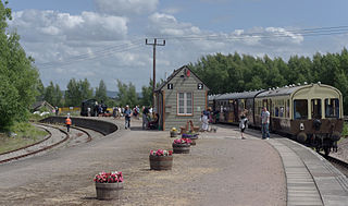
Lydney Junction railway station is a railway station near Lydney in Gloucestershire. The station is now the southern terminus of the Dean Forest Railway. It is located to the south of Lydney, near the A48 road.

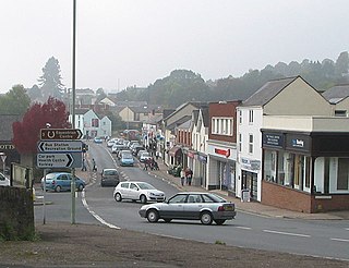
Mitcheldean is a historic market town in the east of the Forest of Dean, Gloucestershire, England.

Lydbrook is a civil parish in the Forest of Dean, a local government district in the English county of Gloucestershire. It is on the north west edge of the Forest of Dean's present legal boundary proper. It comprises the districts of Lower Lydbrook, Upper Lydbrook, Joys Green and Worrall Hill. It has a mile and a half long main street, reputed to be the longest main street of any village in England.

Drybrook is a village and civil parish in the Forest of Dean in west Gloucestershire, England.
The Bullo Pill Railway was an early British railway, completed in 1810 to carry coal mined in the Forest of Dean Coalfield to a port on the River Severn near Newnham, Gloucestershire. It was later converted to a broad gauge steam line by the Great Western Railway, and was closed in the 1960s.
The Forest of Dean Railway was a railway company operating in Gloucestershire, England. It was formed in 1826 when the moribund Bullo Pill Railway and a connected private railway failed, and they were purchased by the new company. At this stage it was a horse-drawn plateway, charging a toll for private hauliers to use it with horse traction. The traffic was chiefly minerals from the Forest of Dean, in the Whimsey and Churchway areas, near modern-day Cinderford, for onward conveyance from Bullo Pill at first, and later by the Great Western Railway.

Berkeley railway station served the town of Berkeley in Gloucestershire, England. The station was on the Sharpness Branch Line, part of the Midland Railway (MR), which connected the Bristol and Gloucester Railway main line at Berkeley Road station with the docks at Sharpness.

The Hereford, Ross and Gloucester Railway, was a railway which ran for 22+1⁄2 miles (36.2 km) linking Hereford and Gloucester via Ross-on-Wye. It was opened on 1 June 1855 as a 7 ft 1⁄4 in broad gauge line, it was amalgamated with the Great Western Railway in 1862. In 1869 the railway was converted to 4 ft 8+1⁄2 in standard gauge. The railway was closed to passengers on 2 November 1964, freight services between Ross-on-Wye railway station and Grange Court railway station continued on until 1 November 1965.

The Coleford, Monmouth, Usk & Pontypool Railway (CMU&PR) was a standard gauge railway of 16 miles (26 km) which ran from Monmouth to Little Mill, near Pontypool in Monmouthshire, Wales. It was intended to convey the mineral products of the Forest of Dean to the ironworks of South Wales, by connecting to the Newport, Abergavenny and Hereford Railway at Little Mill Junction. The NAHR made the onward connection over its Taff Vale Extension line. The CMU&PR intended to acquire the Monmouth Railway, actually a horse-operated plateway, and convert it to locomotive operation.

The Ross and Monmouth Railway was a standard gauge railway of 13 miles (21 km) which ran between Ross-on-Wye, in Herefordshire, England and Monmouth, Wales.
The Forest of Dean Central Railway was a mineral railway line designed to connect certain collieries in the central part of the Forest of Dean to a new dock at Brimspill on the River Severn. It was authorised by Parliament in 1856, but serious difficulties were encountered in raising the money to build it. It opened in 1868 by which time the principal colliery intended to be served had ceased operation. It was unable to finance the construction of the dock at Brimspill and relied on transfer of traffic to the main line of the South Wales Railway.

Weston under Penyard Halt railway station is a disused wood built railway station that served the village of Weston under Penyard in Herefordshire on the Hereford, Ross and Gloucester Railway. Opened in 1929 to compete with local road transport it was located on the Great Western Railway line linking Ross-on-Wye and Gloucester. Nothing remains of the station.
The Monmouth Railway, also known as the Monmouth Tramroad, was a horse-drawn plateway of 3 ft 6in gauge. It ran for about 5 miles (8.0 km) from Howler's Slade, east of Coleford, in Gloucestershire and Monmouth; there were two branches from other mineral sites. It was intended to bring mineral products of the Forest of Dean to Monmouth, and to the works alongside the River Wye.

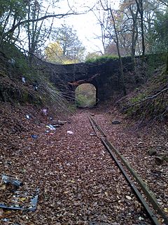
Speech House Road railway station is a disused railway station opened by the former Severn and Wye Railway in 1875, it remained open for 88 years until the line, north of Parkend, closed to freight in 1963. Passenger trains on the Severn and Wye Railway, north of Lydney, were withdrawn from 1929.
The Mitcheldean Road and Forest of Dean Junction Railway was an independent railway company incorporated in 1871, to provide a northerly outlet for iron ore and coal products from the Cinderford and Whimsey area in the Forest of Dean, to the Hereford, Ross and Gloucester Railway line; mineral traffic to industrial centres in South Wales and the Midlands was foreseen.
