
Gloucestershire is a county in South West England. The county comprises part of the Cotswold Hills, part of the flat fertile valley of the River Severn, and the entire Forest of Dean.

The Forest of Dean is a geographical, historical and cultural region in the western part of the county of Gloucestershire, England. It forms a roughly triangular plateau bounded by the River Wye to the west and northwest, Herefordshire to the north, the River Severn to the south, and the City of Gloucester to the east.
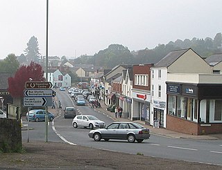
Lydney is a town and civil parish in Gloucestershire, England. It is on the west bank of the River Severn in the Forest of Dean District, and is 16 miles (25 km) southwest of Gloucester. The town has been bypassed by the A48 road since 1995. The population was about 8,960 in the 2001 census, reducing to 8,766 at the 2011 census.

Berkeley is a small town and parish in Gloucestershire, England. It lies in the Vale of Berkeley between the east bank of the River Severn and the M5 motorway, within the Stroud administrative district. The town is noted for Berkeley Castle, where the imprisoned King Edward II is believed to have been murdered, as well as the birthplace of the physician Edward Jenner, pioneer of the smallpox vaccine, the world's first vaccine.
Caldicot is a market town and community in Monmouthshire, southeast Wales, located between Chepstow and Newport on the Gloucester–Newport line served primarily by Caldicot station, whilst by road it is just off the busy M4 / M48 motorway corridor. The site adjoins the Caldicot Levels, on the north side of the Severn Estuary. Caldicot has easy access on the railway west to Newport, Cardiff Central and east to Chepstow, Lydney, and Gloucester, as well as one stop west to Severn Tunnel Junction and then east via the Severn Tunnel to Filton Abbeywood and Bristol Temple Meads and further afield. Generally good road access to Cardiff and across the Second Severn Crossing, old Severn Bridge to Bristol. The population of the town is around 11,000. It has a large school, Caldicot School, and is known for its medieval castle. The built-up area includes Portskewett. Caldicot had a population of 9,604 in 2011.

The A48 is a trunk road in Great Britain running from the A40 at Highnam, 3 miles (4.8 km) west of Gloucester, England, to the A40 at Carmarthen, Wales. Before the Severn Bridge opened on 8 September 1966, it was a major route between England and South Wales. For most of its route, it runs almost parallel to the M4 motorway. During times of high winds at the Severn Bridge, the A48 is used as part of the diversion route and is still marked as a Holiday Route.

Forest of Dean is a local government district in Gloucestershire, England, named after the Forest of Dean. Its council is based in Coleford. Other towns and villages in the district include Blakeney, Cinderford, Drybrook, English Bicknor, Huntley, Littledean, Longhope, Lydbrook, Lydney, Mitcheldean, Newnham and Newent.

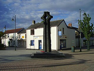
Coleford is a market town in the west of the Forest of Dean, Gloucestershire, England, two miles (3 km) east of the Welsh border and close to the Wye Valley. It is the administrative centre of the Forest of Dean district. The combined population of the town's two electoral wards at the 2011 census was 8,359. It was estimated to be 9,130 in 2019. The parish includes the village of Baker's Hill.

Newnham or Newnham on Severn is a village in west Gloucestershire, England. It lies in the Royal Forest of Dean, on the west bank of the River Severn, approximately 10 miles south-west of Gloucester and three miles southeast of Cinderford. It is on the A48 road between Gloucester and Chepstow, Monmouthshire, Wales. The village has a parish council.

Tidenham is a village and civil parish in the Forest of Dean of west Gloucestershire, England, adjoining the Welsh border. Tidenham is bounded by the River Wye to the west and the River Severn to the south. Offa's Dyke runs through the western part of the parish, terminating at Sedbury cliff above the River Severn.

The Gloucester–Newport line is a railway line that runs along the west bank of the River Severn in the United Kingdom between Gloucester and Newport.

Lydney railway station is a railway station serving the town of Lydney in Gloucestershire, England. It is located on the Gloucester-Newport line. The station is located a mile south of Lydney, and was originally called Lydney Junction, which is now the name of the nearby station on the preserved Dean Forest Railway.
Alvington is a village and civil parish in the Forest of Dean in Gloucestershire, England, situated on the A48 road, six miles north-east of Chepstow in Wales. The parish had a total population of 506 at the 2011 census.

Awre is a village, civil parish and electoral ward in the Forest of Dean district of Gloucestershire, England, near the River Severn.

Aylburton is a village and civil parish in the Forest of Dean district of Gloucestershire, England, on the A48 road about two miles south-west of Lydney. According to the 2001 census it had a population of 689, increasing to 711 at the 2011 census.
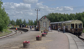
Lydney Junction railway station is a railway station near Lydney in Gloucestershire. The station is now the southern terminus of the Dean Forest Railway. It is located to the south of Lydney, near the A48 road.

The Severn and Wye Railway began as an early tramroad network established in the Forest of Dean to facilitate the carriage of minerals to watercourses for onward conveyance. It was based on Lydney, where a small harbour was constructed, and opened its line to Parkend in 1810. It was progressively extended northwards, and a second line, the Mineral Loop was opened to connect newly opened mineral workings.
Severn Bridge railway station was a small station on the Severn Bridge Railway located close to the north west bank of the River Severn, 2 miles (3 km) northeast of Lydney in Gloucestershire, England.
Sharpness railway station served the village of Sharpness in Gloucestershire, England.

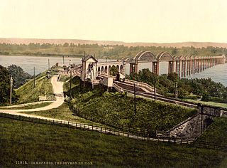
The Severn Bridge Railway was a railway company which constructed a railway from Lydney to Sharpness in Gloucestershire, England. It was intended chiefly to give access for minerals in the Forest of Dean to Sharpness Docks, and the company built a long bridge, 1,387 yards (1,268 m) in length, over the River Severn. The line opened in 1879.


